From the National Hurricane Center
SUMMARY OF 100 AM CDT…0600 UTC…INFORMATION
———————————————-
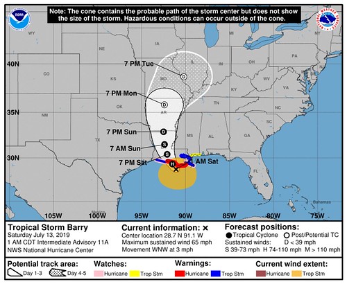
LOCATION…28.7N 91.1W
ABOUT 70 MI…110 KM S OF MORGAN CITY LOUISIANA
ABOUT 125 MI…200 KM WSW OF THE MOUTH OF THE MISSISSIPPI RIVER
MAXIMUM SUSTAINED WINDS…65 MPH…100 KM/H
PRESENT MOVEMENT…WNW OR 300 DEGREES AT 3 MPH…6 KM/H
MINIMUM CENTRAL PRESSURE…993 MB…29.33 INCHES

DISCUSSION AND OUTLOOK
———————-
At 100 AM CDT (0600 UTC), the center of Tropical Storm Barry was located near latitude 28.7 North, longitude 91.1 West. Barry is moving toward the west-northwest near 3 mph (6 km/h). A motion toward the northwest should begin soon, followed by a turn toward the north tonight or Sunday. On the forecast track, the center of Barry will make landfall along the south-central Louisiana coast later today. After landfall, Barry is expected to move generally northward through the Mississippi Valley through Sunday night.
Maximum sustained winds are near 65 mph (100 km/h) with higher gusts. Strengthening is forecast before landfall, and Barry is expected to be a hurricane when the center reaches the Louisiana coast later today. Steady weakening is expected after Barry moves inland.
Tropical-storm-force winds extend outward up to 175 miles (280 km) from the center. A Weatherflow station at Terrebonne Parish, Louisiana, recently reported a sustained wind of 41 mph (65 km/h) with a gust to 53 mph (85 km/h).
The estimated minimum central pressure is 993 mb (29.33 inches).
Courtesy: College of DuPage Meteorology via GIPHY
HAZARDS AFFECTING LAND
———————-
Key Messages for Barry can be found in the Tropical Cyclone Discussion under AWIPS header MIATCDAT2 and WMO header WTNT42 KNHC.
STORM SURGE: The combination of a dangerous storm surge and the tide will cause normally dry areas near the coast to be flooded by rising waters moving inland from the shoreline. The water could reach the following heights above ground somewhere in the indicated areas if the peak surge occurs at the time of high tide…
Intracoastal City to Shell Beach…3 to 6 ft
Shell Beach to Biloxi MS…3 to 5 ft
Lake Pontchartrain…3 to 5 ft
Biloxi MS to the Mississippi/Alabama border…2 to 4 ft
Lake Maurepas…1 to 3 ft
Surge-related flooding depends on the relative timing of the surge and the tidal cycle, and can vary greatly over short distances. For information specific to your area, please see products issued by your local National Weather Service forecast office.
A storm surge of 2.7 feet was recently reported at a National Ocean Service tide gauge at New Canal Station.
RAINFALL: Barry is expected to produce total rain accumulations of 10 to 20 inches over south-central and southeast Louisiana and southwest Mississippi, with isolated maximum amounts of 25 inches. These rains are expected to lead to dangerous, life threatening flooding over portions of the central Gulf Coast into the Lower Mississippi Valley beginning as early as later this morning. Across the remainder of the Lower Mississippi Valley, total rain accumulations of 4 to 8 inches are expected, with isolated maximum amounts of 12 inches. By early next week, Barry is expected to produce rainfall accumulations of 4 to 8 inches across western portions of the Tennessee Valley.
WIND: Hurricane conditions are expected in the Hurricane Warning area later this morning, with tropical storm conditions currently spreading across the area. Hurricane conditions are possible within the Hurricane Watch area later this morning. Tropical storm conditions are occurring across the Tropical Storm Warning area in southeastern Louisiana at this time. Tropical storm conditions are possible in the Tropical Storm Watch area later today. Wind gusts to tropical-storm force in squalls are possible along portions of the coasts of Alabama and the western Florida Panhandle through tonight.
TORNADOES: A couple tornadoes are possible late today across southeast Louisiana and southern Mississippi.


