Author: Nick Lilja
|| Published: 7/29/2020 at 12:48am
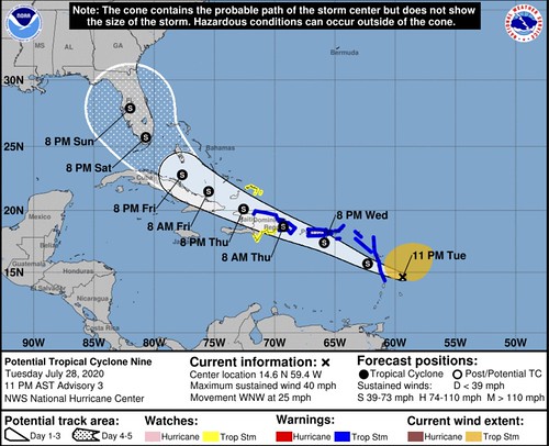
The National Hurricane Center continues to monitor Potential Tropical Cyclone Nine. The storm is likely going to be named Isaias in the coming days.
It isn’t forecast to be near Florida and the Bahamas until Friday or Saturday, but I wanted to take a few minutes to dive into an important set of data: Water temperatures.
A quick note: The water is warm
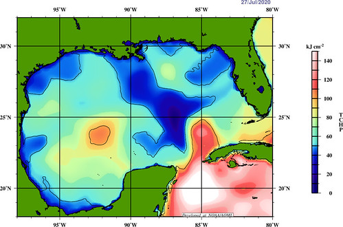
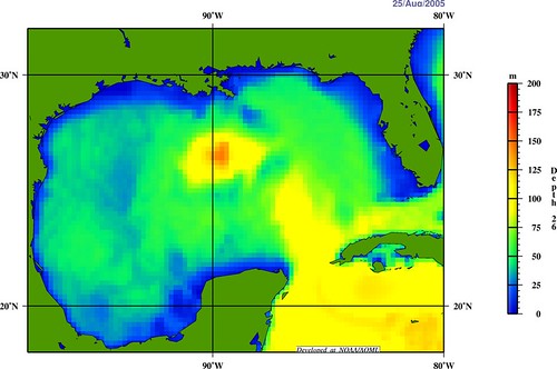
Here is the current look at the Tropical Cyclone Heat Potential in the Gulf.
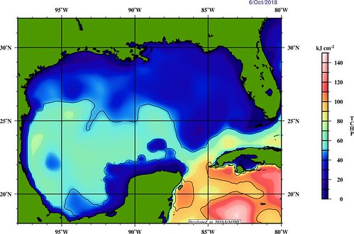
This shows a fair bit more “potential” than the last time a tropical system went through Rapid Intensification in the Gulf. The last storm to do that was Hurricane Michael. At that time the same gulf waters looked like this:
While the “loop current” is as “loopy” this year out in the center of the Gulf, there is still plenty of warmer water out there for tropical systems to use for development and strengthening.
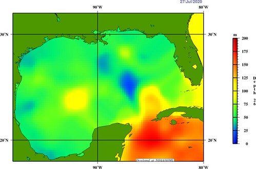
The 26-degree Celsius isotherm is another map to track when trying to identify if intensification of tropical systems is possible. Truly, I need to make n entire post about the 26C isotherm at some point. For now, just know it is a parameter that becomes very important for intensification purposes.
Today, the 26C isotherm is relatively shallow across most of the gulf of Mexico with a few spots where the depth sinks to more than 75 meters. Past research I’ve read suggests that an isotherm depth of more than 100 meters is sufficient to greatly aid in the development of a Major Hurricane.
26-degree Celsius isotherm showing the depth of the warm waters // Courtesy AOML
At this time, there are only a few areas where those depths are realized. Off the coast of Cuba, out in the central-western Gulf and then a small area off the coast fo Alabama and Florida.
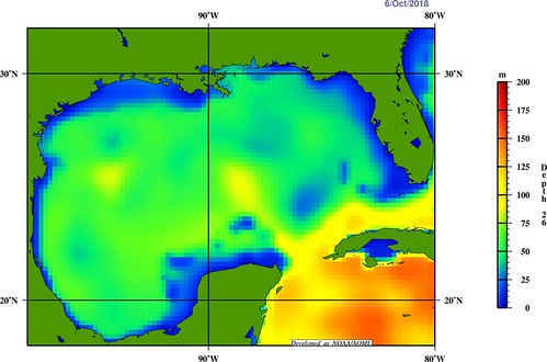
You can see the difference between now and Michael:
26-degree Celsius isotherm showing the depth of the warm waters // Courtesy AOML
And for reference, during Katrina:
26-degree Celsius isotherm showing the depth of the warm waters // Courtesy AOML
Notice how warm the water are now – generally – compared to the most recent Major hurricane in the Gulf and one of the more catastrophic Major Hurricanes in the Gulf to make landfall in Mississippi.
Does this mean that it is “definitely going to be a Major Hurricane” if Isaias gets into the Gulf? No. Nothing is guaranteed in the Tropics. Except perhaps uncertainty.
So, Nick, what does this mean?
A lot of you guys already know that warm waters are the fuel for these tropical systems. But the volume of the warm water (the depth and width) is just as important – if not more important – than just the surface temperature. And the current warmer waters in the Gulf mean that any storm, be it Isaias or a different one, will have plenty of energy to use to gain strength.
We saw a bit of that with Hurricane Hanna. Originally pegged to be a Tropical Storm at landfall. It strengthened – quickly – into a Hurricane once it got organized because it was able to tap into that extra energy.
Back to PTC9 / Isaias
The not-yet-named system is still trying to gain organization. It is struggling for two reasons: dry air and a wee-bit of shear.
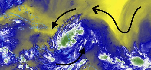
Mid-level water vapor imagery // Courtesy: College of DuPage Meteorology
That mid-level water vapor imagery shows that some dry air surrounds the storm. And the forward speed of the system itself – moving at about 20mph – is causing it to be a bit one-sided.
From the NHC:
Earlier wind data from an Air Force reconnaissance aircraft and a recent 0038Z ASCAT-A overpass indicate that the disturbance has not become any better organized since the previous advisory. There were indications of a circulation center located near the position estimate used in this advisory. However, there was a sharp cusp noted in the ASCAT wind field, and that was used for positioning the disturbance since it lies closest to the strong convective band and best upper-level divergence. The initial intensity of 35 kt is based on several ASCAT wind vectors of 35-36 kt located well north of the center.
Courtesy: nhc.noa.gov
The 35-kt intensity is also consistent with a 0000Z TAFB Dvorak satellite intensity estimate of T2.5/35 kt.
The initial motion estimate is an uncertain 295/22 kt. The ridge to the north of the disturbance is forecast to remain strong for the next 36-48 h, which keeps the system moving in a general west-northwestward direction across the Lesser Antilles tonight and Wednesday, and near or over the Greater Antilles Wednesday night and Thursday. For such a loosely organized system at this time, the models are in fairly good agreement on the large disturbance slowing down significantly after 48 h, reaching forward speeds of only 10-12 kt when it reaches the very warm waters of the Straits of Florida in 72-96 h.
On days 4 and 5, the system is expected to slow even further and turn northward into a break in the subtropical ridge that is expected to develop across Florida and the Bahamas. The new NHC track forecast is similar to but a little south of the previous advisory track, mainly due to the more westward initial position, and lies along the southern portion of the guidance envelope near the middle of the consensus models.
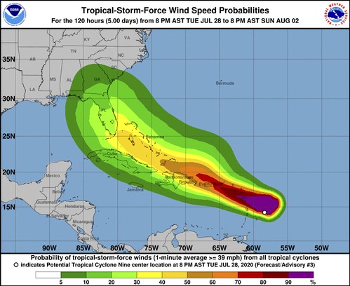
Regardless of the exact track, the system is expected to bring locally heavy rainfall to much of the Lesser Antilles, and tropical-storm-force winds to portions of the Leeward Islands, the Virgin Islands, and Puerto Rico during the next 24 hours.
Courtesy: nhc.noaa.gov
The intensity forecast remains problematic for primarily two reasons: 1) the lack of a well-defined center and inner-core wind field and 2) likely land interaction to some degree. In the short-term, a bonafide center could develop tonight in response to the expected development of intense convection caused by orographic forcing by the mountainous islands of the central and northern Leeward Islands. Once a center closes off, which has likely been inhibited from doing so due to the disturbance’s fast forward speed in excess of 20 kt, the low-level convergence will improve and convection will become more organized and symmetrical, allowing for strengthening to occur.
The main question is how much land interaction with Puerto Rico and Hispaniola will disrupt the circulation in the 36-48-hour period. Assuming the system remains intact after emerging off the coast of Hispaniola, the slow track over the very warm waters of the Straits of Florida would result in more strengthening, assuming the system doesn’t interact with the Cuban landmass. Although the GFS-and ECMWF-based SHIPS intensity guidance shows considerable southwesterly vertical wind shear of 20-30 kt in the 72-96 h period when the disturbance is over the Straits, the global model fields show that this is self-induced shear caused by the SHIPS model incorporating the system’s impressive upper-level outflow winds in its shear calculations.
As a result, this is not being considered a negative intensity factor compared to land interaction. Due to aforementioned uncertainties, the new NHC intensity forecast remains on the conservative side, and lies between the slightly weaker IVCN and stronger NOAA-HCCA consensus models. Interests in Hispaniola, the Bahamas, Cuba, and Florida should continue to monitor forecasts as changes to both the track and intensity are likely.
As the National Hurricane Center noted, some of the deep convection developing within this storm may be the catalyst for development. Thinking back to Hurricane Harvey, some of you may remember the “nocturnal convection” that erupted with that storm caused the center to manifest quickly and was the catalyst for Rapid Intensification. With PTC9/Isaias, Rapid Intensification doesn’t appear as likely, but it also can’t be ruled out.
The SHIPS model guidance from 00z on 7/28/20 showed about a 20-percent chance that it will gain 25kts of wind speed during the next 24 hours. It also showed a 20-percent chance of gaining 55kts of wind speed during the next 72 hours.
And the forecast track is going to be highly-dependent on the strength and organization of the system. So everything is still a bit – pardon the pun – up in the air at the moment.
Get nerdy with Tropical Tidbits
Levi Cowan runs Tropical Tidbits. It is a great site for weather data. A site that is also nice enough to allow me to use those graphics in some of my weather discussions.
Levi is also a fantastic tropical meteorologist. He does his own version of our Tropical Update, but he gets way more into the nitty-gritty details. It is great stuff. And I wanted to showcase it here for those who are interested in really digging into the details further.
The Bottom Line
Climatology tells us that the northern Gulf Coast should keep tabs on this storm until the models can come into better agreement. Brad Panovich, who is a meteorologist in Charlotte, points that out here:
This is strictly climatology based on the current position of #PTC9, as the track starts to shift towards the Gulf the chance of U.S. landfall increases. pic.twitter.com/qxN1HR5fTQ
And models won’t come into better agreement until the center of the system develops. And the center of the system won’t develop until more robust convection can slow down the forward momentum. And robust convection is just now beginning to form.
So it may be another 12 to 36 hours before the picture starts to sharpen up a bit.
So, for now, double check your Hurricane Preparedness Kits and make certain that you are ready to go should a tropical system threaten your region. Double-check supplies like food and water. When was the last time you ran your generator? Are all of the shrubs and loose branches around your house trimmed? Now is a good time to think about all of those small things that can quickly add up when a storm may be closer.
Author of the article:
Nick Lilja
Nick is former television meteorologist with stints in Amarillo and Hattiesburg. During his time in Hattiesburg, he was also an adjunct professor at the University of Southern Mississippi. He is a graduate of both Oregon State and Syracuse University that now calls Houston home. Now that he is retired from TV, he runs this site and its app in his spare time.