The National Hurricane Center designated the little area of disorganized storms in the Caribbean as Invest 99L. That allows the NHC to start running specialized tropical forecast models on the system.
There is still a lot of stuff that is up in the air with Invest 99L. But this morning the models are giving hints as to the ‘fence’ of possibilities.
The general idea is that it will lift out of the Caribbean during the next few days, get intot he Gulf this weekend and then make landfall – somewhere – during a window between late Sunday night and early Tuesday morning.
Model data
This is – understandably – a bit jarring to see. Perhaps even a bit scary or unnerving.

Seeing the model guidance bend back to the east like this has probably got many people from Brownsville, Texas to Mobile, Alabama sitting up.
Couple that with the other model gduiance.

And, again understandably, you may feel a bit of uneasiness. Then you seee things like this floating around…

And, look I get it. It is comfortable to see.
But, I have some good news. Not all of it is good. But some of it may be.
Model Analysis
The model tracks for Invest 99L are tied directly to how strong the system becomes. The stronger it is, the faster it develops, and its ability to dodge land, all impact how thigns will play out.
And in the model guidance above you are seeing only a handful of possibilities. And currently, there are, like, nearly infinite possibilities. Why? Because it is still very early in the life cycle of the tropical system.
And remember! Like I always say, many models really, really struggle with things until a tropical system can form a centralized are of low pressure. Without a centralized area of low pressure, models have a difficult time “grabbing ahold” of the system itself, in order to make a prediction about where it may go.
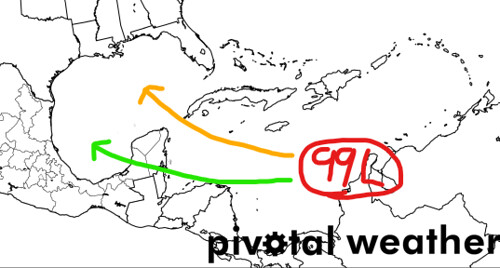
In the image above, the orang track is the more likely movement if it develops quickly and gets stronger while the green track is the general movement if it remains disorganized and stays weaker.
And likely, the track will be some mixture of the two.
What to do right now
Continue to keep tabs ont he forecast and double check your Hurricane Prep Kit. Who needs to worry?
If you live between Tampico, Mexico and Pensacola, Florida… you need to be monitoring this storm on a daily basis. Check in, see what is going on with it.


