Tropical Storm Dorian continues to move through the Caribbean after moving through the Martinique and St. Lucia.
Here is the latest from the NHC:

SUMMARY OF 1100 AM AST…1500 UTC…INFORMATION
———————————————–
LOCATION…14.2N 61.8W
ABOUT 60 MI…95 KM WNW OF ST. LUCIA
ABOUT 415 MI…665 KM SE OF PONCE PUERTO RICO
MAXIMUM SUSTAINED WINDS…50 MPH…85 KM/H
PRESENT MOVEMENT…WNW OR 295 DEGREES AT 13 MPH…20 KM/H
MINIMUM CENTRAL PRESSURE…1005 MB…29.68 INCHES
Dorian Discussion from the NHC
At 1100 AM AST (1500 UTC), the center of Tropical Storm Dorian was located by data from an Air Force Reserve reconnaissance aircraft and the Martinique radar near latitude 14.2 North, longitude 61.8 West. Dorian is moving toward the west-northwest near 13 mph (20 km/h), and this motion is expected to continue through tonight, followed by a turn toward the northwest on Wednesday. On the forecast track, the center of Dorian will move across the eastern and northeastern Caribbean Sea during the next few days, passing near or south of Puerto Rico on Wednesday, move near or over eastern Hispaniola Wednesday night, and move north of Hispaniola on Thursday. On Thursday night and Friday, the center of Dorian is forecast to move near the Turks and Caicos and southeastern Bahamas.
Maximum sustained winds remain near 50 mph (85 km/h) with higher gusts. Slow strengthening is forecast during the next 48 hours, and Dorian is forecast to be near hurricane strength when it moves close to Puerto Rico and eastern Hispaniola.
Tropical-storm-force winds extend outward up to 45 miles (75 km) from the center.
The estimated minimum central pressure is 1005 mb (29.68 inches).
Model Data
The meteorologists at the National Hurricane Center are doing a gret job considering the difficulty of forecasting a storm of this size (small). Global models seem to be struggling to offer valuable intensity guidance given the storms small size. And because the global models are struggling with intensity, they also, in turn, are struggling with forecast track.
However, given the multiple passes from the Hurricane Hunters, that should be improving during the day today. Plus, the higher-resolution models should be able to grab a hold of that new data to offer better guidance as well.
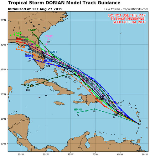
In fact, one could argue that is already happening given the ‘togetherness’ of the track guidance from the models.
That said, the model guidance for intensity is still… less than ideal.
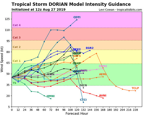
Not exactly helpful, right?
Good luck, Florida! According to the computes Dorian will be somewhere between a weak tropical storm and a Category 4 hurricane.
This is why Human meteorologists are so important to the forecast process. In particular, the smart people at NHC. The current forecast is for Dorian to be a stout Tropical Storm as it approaches Florida on Sunday morning. The computer data is flawed due to the small size of the storm and the computers struggle to resolve that relative to the other atmospheric conditions in the area.
More from the NHC
Tropical Storm Dorian Discussion Number 13
NWS National Hurricane Center Miami FL AL052019
1100 AM AST Tue Aug 27 2019
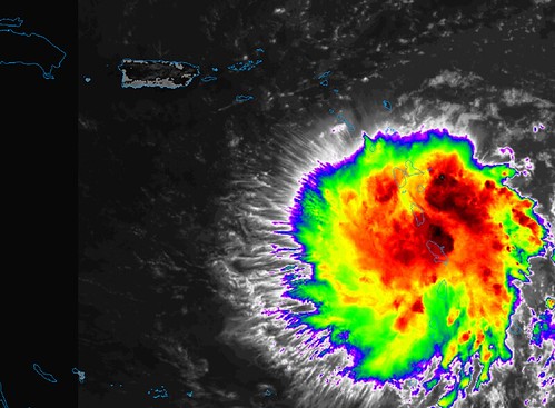
Dorian moved directly across the center of St. Lucia around 1000 UTC, which resulted in a significant disruption of the small inner-core wind field. An Air Force Reserve reconnaissance aircraft had difficulty identifying a clear-cut center and radar data from Martinique indicates that the mid-level circulation has also been disrupted somewhat. Having said that, the overall appearance of the cyclone in both satellite and radar imagery has improved since this time yesterday, although a pronounced dry slot is now evident in the southeastern quadrant of the circulation. The initial intensity of 45 kt is being maintained based on aircraft flight-level and SFMR surface wind data.
The initial motion remains west-northwestward or 295/11 kt. There is still no significant change to the previous forecast track or reasoning. Although the inner-core wind field and low-level center have been disrupted, the overall circulation envelope has remained intact and is expected to move west-northwestward to northwestward for the next 36-48 hours toward a break in the subtropical ridge located well north of Dorian. The mid- to upper-level low currently located east of the Bahamas that has weakened the ridge is forecast to gradually weaken while digging southeastward across the central Bahamas and toward central Cuba over the next 3-4 days, resulting in Dorian turning northwestward on day 3 before turning back toward the
west-northwest on days 4 and 5. How quickly the west-northwestward turn occurs will depend heavily on the evolution of the upper-low. For now, the previous forecast track remains unchanged other than to push out the track a little northeastward at 48 and 72 hours. The NHC model guidance remains tightly packed and in good agreement on this scenario, and the new forecast track lies very close to an average of the various consensus track models. Users are reminded not to focus on the details of the extended track forecast as the
average 5-day track error is around 200 miles.
Dry air continues to plague Dorian, and interaction with the mountainous terrain of St. Lucia will likely hinder significant development in the short term. However, the models continue to indicate that the upper-level flow pattern and shear conditions are expected to remain favorable for strengthening throughout the
forecast period, so it is uncertain why the dynamical models are not showing more development and strengthening when compared to the more robust statistical SHIPS intensity models, especially at days 4 and
5 when Dorian will be moving over SSTs greater than 29 deg C and into a fairly moist environment. For now, the official intensity forecast remains basically midway between the stronger SHIPS model and the much weaker global and regional models. Given the large spread in the guidance, there is lower than normal confidence in the intensity forecast, especially on days 4 an 5.
Key Messages from the NHC
1. Tropical storm conditions will continue in portions of the Lesser Antilles during the next several hours. Tropical storm conditions are expected and hurricane conditions are possible in Puerto Rico on Wednesday and in portions of the Dominican Republic Wednesday night and Thursday.
2. Heavy rainfall over portions of the Lesser Antilles, Puerto Rico, and the Dominican Republic could produce flash flooding during the next few days.
3. The threat of winds and heavy rains later this week into this weekend in the Turks and Caicos, the Bahamas, and Florida is increasing. Residents in these areas should monitor the progress of Dorian and ensure that they have their hurricane plan in place.
4. Uncertainty in the intensity forecast later this week remains higher than usual due Dorian’s potential interaction with Hispaniola and Puerto Rico.
The parts of the forecast that are a total lock
No parts. This forecast is likely to change. Sadly, with tropical systems nothing is ever truly ‘locked in’ which is why we always encourage you to follow the forecast with these systems closely. It is also why we try our best to kick out new forecasts as much as possible.
The Bottom Line
Right now – unless you are reading this from the Caribbean – we are in a wait-and-see position. Circling the airport, so to speak. For Gulf Coast folks, as I mentioned last night on the 10p news, we may have to wait until Thursday evening before we get a better idea about what it means for the Louisiana, Mississippi and Alabama region.
So for now, check your Hurricane Preparedness Kit, Check your supplies, make sure you have a plan. But outside of that, just hang tight!


