Alrighty, friends. So here is the deal, Tropical Storm Dorian is small(ish) and the models don’t seem to be doing a great job with the data. So expect (yes, expect) changes to this forecast. And expect those changes to be more than just ‘where will it be three or four days from now?’ but also ‘how strong will it be in 24 hours?’.
Right now
Here is the latest from the NHC on Dorian:

Model Data
The question becomes, if the models aren’t handling Dorian well, then why use the models? Well, we don’t have much of a choice. When all the options are bad, rather than just throwing your hands up at quitting, you have to figure out why things are bad, and then manage the ‘badness’ as best as possible.
Plus! Since we know the models are struggling and we are starting to see how they are struggling, we can make predictions from those struggles (though, that an get a bit dicey).

Notice that the spaghetti models arc Dorian a bit more north and then flatten it back more west as it approaches the Florida coastline. This goes back to something I was talking about last night on facebook.
You can catch that video here:
With an upper-level low sagging southwest across Dorian’s path, the two systems were going to do a sort-of dosey doe (I had to Google how to spell that) around each other (arc more north). And then a day later, Dorian was going to interact with a ridge of high pressure to the north (flatten more west).
Despite the model data last night not showing that, there was an expectation that it would eventually show up.
And in the word of Emeril Lagasse, ‘BAM!’ there it is.
Not the question becomes what is the storm going to do with all of that extra time over the warm water. Since instead of making a bee-line for Florida it is going ot arc up and the flatten back west, that means it will spend more time over the warmer waters.
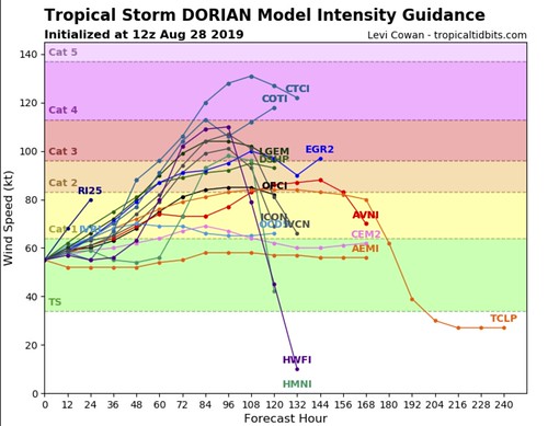
As you can imagine, some of the models suggest – with good reason – that the system will strengthen. But not all of them. There is still a pretty wide spread. You can see that within the next 72 hours some models think it will still be a Tropical Storm while others think as strong as a Category 4 Hurricane.
Which one is right? Neither! Recall the models are struggling with this little storm, so the chance that one computer model is correct is probably pretty low.
Instead, what we can do is look at some of the underlying factors and make out own assessment (this is why having a human meteorologist is still much better than always relying on a computer).

On the graphic above, setting the two pictures on the left aside, notice that on the right side, the deep layer shear will remain below 15kts through September 1st, the seat surface temperatures are going to remain ‘at or above’ 28-degrees Celsius, and the dry air is going to decrease (mid-level Relative Humidity is increasing).
Those factors lead me to believe to that Dorian will be in a reasonably favorable environment for strengthening. And, depending on how it wraps itself up in the short-term, a short bout of Rapid Intensification cannot be ruled out.

So what will it look like in – roughly – 12 hours? Take a look at the graphic above. The HWRF model generally does a decent job with tropical systems in the short term because it is designed for it. The GFS and Euro models are great, but they aren’t designed specifically to handle smaller features.
The HWRF has its own problems, but for shorter-than a 36-hour forecast, its pretty good.
It shows Dorian still getting wrapped up at this point, with most of the storms on the north side of the system. That is from the interaction with Puerto Rico as well as a bit of the shear touched on above.
But once it gets way from the island and gets itself wrapped up – aided by the warmer waters – it looks like intensification will be possible.

The Rapid Intensification guidance shows that, during the next 72 hours, Dorian is 4.5-times more likely to undergo Rapid Intensification than the average storm. That means a 65kt jump in wind speed.
The 12z model was rendered when Dorian had wind of 60mph. So that means there the model suggested an increase in wind speeds to 134mph would be possible – but not ‘likely’ – during the next 72 hours.
Discussion form the NHC
Tropical Storm Dorian Discussion Number 17
NWS National Hurricane Center Miami FL AL052019
1100 AM AST Wed Aug 28 2019
Satellite and radar images indicate that the cloud pattern has become better organized during the past several hours. This was confirmed by data from an Air Force reconnaissance plane currently investigating Dorian, which reported a flight-level wind of 72 kt and a peak SFMR value of 60 kt. The estimated central pressure was 999 mb in the last fix. On this basis the initial intensity has been adjusted upward to 60 kt. Only a slow strengthening is anticipated today while Dorian is moving through the U.S. and British Virgin Islands. However, once the cyclone reaches the western Atlantic well east of the Bahamas, it will encounter a favorable environment of low shear and warm waters, resulting in a more marked intensification. The NHC foreast is more aggressive than the previous one, and brings Dorian to category 3 intensity by the end of the period. This forecast very closely follows the intensity consensus, the HCCA model, and the SHIPS guidance.
Fixes from the reconnaissance plane indicate that Dorian has been moving toward the northwest or 315 degrees at 11 kt. The cyclone is heading toward a weakness in the Atlantic subtropical ridge, and this motion should continue for the next 2 to 3 days. However, after that time, all global models build a robust ridge over the western Atlantic, and this flow pattern should force Dorian to turn more to the west-northwest toward Florida and the southeast coast of the United States. All indications are that by this Labor Day weekend, a
powerful hurricane will be near the Florida or southeastern coast of the United States. The new NHC track forecast is not significantly different from the previous one, and it very closely follows the multi-model consensus TVCA and the HCCA. Users are reminded not to focus on the exact forecast track, as the average 5-day track error is around 200 miles.
Key Messages
Key Messages:
1. Hurricane conditions are expected in the U.S. and British Virgin Islands, Culebra, and Vieques today. Tropical storm conditions are expected in Puerto Rico today with hurricane conditions possible.
2. Heavy rainfall over portions of Puerto Rico and the U.S. and British Virgin Islands could produce flash flooding during the next couple of days. Heavy rains are expected to occur over portions of the Bahamas, Florida, and elsewhere in the southeastern Untied States later this week and into early next week.
3. The risk of dangerous storm surge and hurricane-force winds is increasing in the central and northwestern Bahamas and along the Florida east coast, although it is too soon to determine where these hazards will occur. Residents in these areas should ensure that they have their hurricane plan in place and not focus on the exact forecast track of Dorian’s center.

FORECAST POSITIONS AND MAX WINDS
INIT 28/1500Z 17.5N 64.5W 60 KT 70 MPH
12H 29/0000Z 18.7N 65.7W 65 KT 75 MPH
24H 29/1200Z 20.5N 67.0W 65 KT 75 MPH
36H 30/0000Z 22.4N 68.4W 70 KT 80 MPH
48H 30/1200Z 24.2N 69.9W 75 KT 85 MPH
72H 31/1200Z 26.5N 74.0W 90 KT 105 MPH
96H 01/1200Z 27.7N 77.7W 100 KT 115 MPH
120H 02/1200Z 28.6N 80.3W 100 KT 115 MPH
Answering your questions
Dawn Bryant asks, “Isn’t Dorian almost a cat3 right now?”
Thankfully, no. Right now, Dorian is a strong Tropical Storm with wind at 70mph. But the radius of the maximum wind only stretches out about 15 miles. The entire storm is only about 125 miles across. That is shorter than the distance between Hammond, Louisiana and Mobile, Alabama.
Kristen McCormick asks, “Do us in the pine belt need to worry about this???”
Not yet. This is still pretty far out there. If – and a big if, there – this were to move toward the Gulf and south Mississippi… It wouldn’t get there until next week.
That said, these types of situations are always a good reminder to check your Hurricane Preparedness Kit and make sure you’ve got plenty of supplies.
Tina Emler Neal asks, “I’m hearing can be a cat 3? Is there any truth to that?”
Yes! The NHC is now forecasting Dorian to be a Category 3 Hurricane as it travels through the Bahamas.
Pam Snyder Wylie asks, “Based on the current small size of the storm- what are the chances it will get bigger? Is Dorian likely to become a cat 3 or higher if it hits the waters in the gulf or is it too soon to tell?”
Right now the forecast is for it to become a Category 3, but the forecast isn’t for it to move into the Gulf unimpeded. That means it will have to cross over land if – and again, a big if – it were to move toward the Gulf. As far as it growing in size, that is still a bit of an unknown at this point.
Megan Bush Norris asks, “What has caused the more northward shift and can that change?”
The shift north is due to the interaction with the upper-level low and the ridge of high pressure. Plus, in general, strong storms tend to drift more north due to the Coriolis Effect.
The parts of the forecast that are a total lock
No parts. This forecast is likely to change. Sadly, with tropical systems nothing is ever truly ‘locked in’ which is why we always encourage you to follow the forecast with these systems closely. It is also why we try our best to kick out new forecasts as much as possible.
The Bottom Line
Right now – unless you are reading this from the Caribbean – we are in a wait-and-see position. Circling the airport, so to speak. For Gulf Coast folks, as I mentioned last night on the 10p news, we may have to wait until Thursday evening before we get a better idea about what it means for the Louisiana, Mississippi and Alabama region.
So for now, check your Hurricane Preparedness Kit, Check your supplies, make sure you have a plan. But outside of that, just hang tight!


