The toughest part about working a full time job, living eight hours away from my girlfriend and on the other side of the country from my entire family is that trying to make time for anything but those three things is tough. Even tougher with a potential tropical system!
So, I apologize for the later-and-less-robust post today.
The good news is this should be a bit more streamlined and not as long as yesterday.
Ain’t too much changed
The good news is that there hasn’t been much change to the forecast since yesterday. The data carried a bit more weight today as we are starting to get a low-level center on Invest 98L this afternoon. But much of the movement today was meaningless as the models haven’t recognized the center as being where the center is yet.
And until we start with something meaningful, we can’t end with something meaningful.
That is also why the spaghetti models are mostly unchanged and the intensity guidance is almost the same, too. The models don’t have much extra info to go on to make a different forecast.


I’m sure there are a ton of posts and other meteorologists out there with NEW DATA, BREAKING NEWS and FIRST ALERT COVERAGE, but I’m here to tell you the straight facts. And those facts are: not much has changed since last night.
The main difference is that low level center. But there isn’t much convection near it. A bit like Fiona last week, the center is exposed. Unlike Fiona last week, there is barely any convection at all near the system whatsoever.
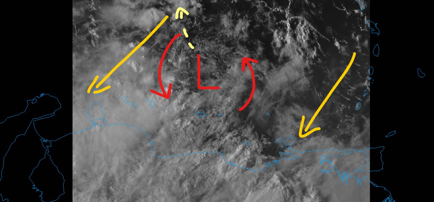
Plus it is also really close to a lot of land (South America). There are more “failure factors” right now than anything else. That is probably while it is struggling to develop.
Tomorrow means something
Now that we do have that low-level center, even if it is weak and has limited convection around it… it is there. So, now we watch what it does and what path it takes. From there, we can determine which guidance (models) are handling it better than others.
This afternoon, it was located at 12N, 66W. The Euro shows the middle of the cluster as near 14N, 70W tomorrow morning, the GEFS shows 13.5N, 70W. Not a big difference, but it is meaningful! And that is what we are missing right now, any meaningful data. So we will take anything we can get.


The Hurricane Hunters did fly by the system last night, but due to the proximity to land couldn’t make full passes. Tomorrow, it is likely they will get a shot as it is slated by model guidance to lift northward.
Shear continues
Still looks like Invest 98L has about 48 hours left of this sheared environment. That means any organization and development should remain limited. Nothing news there, I suppose. But beyond that point is when things lighten up quite a bit.

And once things lighten up, that is when the real organization and development should begin. And 48 hours from now is Sunday night.
That is why the SHIPS numbers for any kind of Rapid Intensification are so low. Too much shear.

Once we get past 48 hours, though, the numbers do increase.
The Bottom Line
Since not much has changed with the storm, not much has changed with the bottom line! Whatever is out there won’t be somewhere near the US until the middle of next week. At the soonest.
If you live anywhere from about New Orleans to Miami you should probably double-check your Hurricane Prep Kit. You may not need it, but I’d check it to make sure it is ready to go. If you live along the water, I’d double check the evacuation routes. If you live inland I’d double check around the house to make sure there aren’t any loose branches on trees or leaves clogging up the gutters and storm drains in the roads.
The nice thing about being prepared is it gives you peace of mind. And it makes the storm not as bad if/when it rolls through. The old saying, “An ounce of prevention is worth a pound of recover” is so true.


