The National Hurricane Center continue to monitor Tropical Storm Ian in the Caribbean and update the track every three to six hours.

A Hurricane Watch is in effect for the Cayman Islands. A Tropical Storm Watch is in effect for Jamaica. No Watches/Warnings are in place for the United States at this time.
WHAT WE KNOW
If you life east of Morgan City, Louisiana along the Gulf Coast and up to 75 miles inland, you should be paying very close attention. That is a big thing we know.
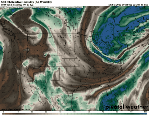
The tropical system, as a whole, is looking generally healthier this morning. A look at the Infrared imagery shows a few towers, some exhausting on the southwest side, and occasional gravity waves emanating from the center.

We also know it has shift – every so slightly – to the south of its westerly trek since yesterday. Currently it is sitting at 14.4N 75.2W, and it was named a tropical storm at 14.8N 72.0W. Not a “big” shift south, but it is meaningful – particularly for folks living on the west side of the Forecast Cone (I’ll explain that below).
The water it will be traversing is also still very warm. No changes there.

And we know that these tropical systems need the warmer water to grow and organize. According to satellite data, Tropical storm Ian will be moving over the “coldest” water of the rest of its journey during the next 18 hours. And this water is still warmer than 82F to a depth of 50m – which is plenty warm for a tropical system to grow.
WHAT WE THINK WE KNOW
Or, in other words, what we are pretty sure about at this point, but can’t say with absolute certainty….
We are pretty sure that Tropical Storm Ian will make it into the Gulf of Mexico. The Super Ensemble guidance – this is a forecast map that looks at nearly every bit of ensemble data we have available – suggests that Ian will make it to the Gulf with nearly 100-percent certainty.

Like i always say, though,

Which is why I can only say that I am really, pretty, very sure – but not completely certain. There is still an escape route toward central America. There isn’t really one that spits Ian out into the Atlantic and skips the Gulf, though.
We are also pretty sure it will strengthen into – at least – a Category 1 Hurricane. The jury is still out on the top end, but I’ll explain that more below.

But briefly, the SHIPS guidance does a good job at identifying the potential for intensification and the numbers are currently uncomfortably healthy, so there is some higher-then-normal confidence that this thing will grow into – at least – a Category 1 Hurricane.
There isn’t really a “front” that is going to “save” anyone from anything. I don’t know where this started, or how it started, but there seems to be a wave of people (and meteorologists, too) that think a front is going to push south and steer Ian one direction or another.
That is not true. It is either people over-simplifying things because they think you are too dumb to understand or they are under-educated about how things actually work.
If it were true, it would actually do something a bit different. Take a look at the illustration below….

The pic on the left shows the front that is set to move through on Monday. The blue arrows behind the front indicate the wind direction behind the front. the “I” in the circle is where Tropcial Storm Ian is anticipated to be (though we don’t actually know where it will be specifically). Fast forward (following the big black arrow) to Wednesday on the right, and the front slides into the Gulf. And starts to interact with Ian – where ever it is. But notice the blue arrows behind the front would actually be encouraging Ian to slide back to the west at that point.
But that isn’t how deep tropical systems work. Thankfully. So that isn’t really a potential outcome. Keeping in mind this section is for the things we are pretty, really sure about. Not a certainty, but we are feeling pretty confident.
Instead, what will happen is a peice of ‘umph’ in the mid-to-upper levels is going to swing down and interact with Ian to move it one direction or another. Or not at all. Like the animation below
Notice the darker brown area flowing SE out of the Rockies and toward the Carolinas. This is what will push Ian. But we also don’t know where that umph will be, how strong it will be and what its trajectory will be yet. We will talk more about that below!
But suffice to say, if you read something from someone saying, “a front will save the Gulf” you can probably write off their analysis as either underinformed or under-communicated. Both are bad. There is something out there that may potential move Ian, but a “front” is not it.
WHAT WE DON’T KNOW
We still don’t know a fair bit. Like usual in these types of situations. But we continue to chip away at the block. And the goal is the more we learn about this storm and all of the puzzle pieces in place, the more we can move from this section, into the section above.
The top thing we are still trying to nail down is exactly how the trough-vs-tropical-storm battle will play out.

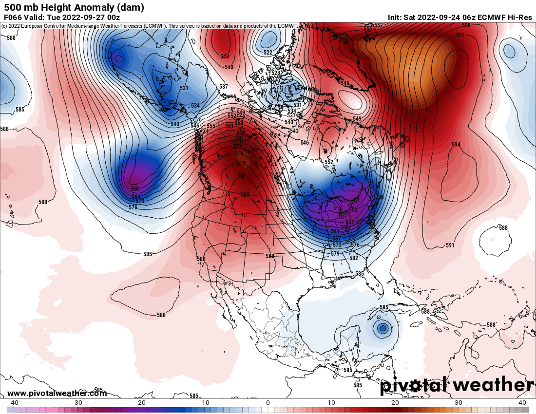
There are some very subtle differences between the two maps above. And those very subtle differences will be part of the equation that decides how far west or east Tropical Storm Ian decides to trek.
And how deep these troughs dig is tied to a piece of atmospheric energy currently hanging around near Alaska. The more potent it is as it moves south, the farther south the trough digs and the more east Ian will push as it moves north.

That uncertainty is playing out in teh ensemble guidance, too. And that guidance has shifted the track west in response to the potential for the trough to be not as robust or deep

On top of that, we are unsure of its top-end intensity and how strong it will be as it moves closer to shore. As pointed out by Tomer Burg on Twitter, the longer it stays over the warmer water, the strong the system will become.
That is part of the SHIPS guidance shown above. It calls for a really good chance for Rapid Intensification at some point during Ian’s trek through the Caribbean and southern Gulf. That is why we are pretty sure it will be – at least – a Category 1 Hurricane. But we are still uncertain about how strong it will get.
The stronger it is, the more likely it will be to shield itself from the surrounding environment when said environment becomes less hospitable. So this becomes important when we talk about interacting with low-level dry air or mid-level troughs.
Currently, beyond the guidance above, the more hurricane-centric models show a track and intensity that is mostly unchanged, with some slight easing west during the last 24 hours.


But this also has to do with all of the things we don’t know mentioned above. And these models will continue to shift west if the trough continues to look less deep and they will shift more east if the trough looks deeper.
WHAT WE CAN’T KNOW
Specifics about landfall. A lot of folks want to know where will get hit and at what time and when it will be over. And sadly, we don’t know that yet. I can ballpark it! But that is about as good as it gets.
The National Hurricane Center Forecast Cone is about as good as it gets right now. It is running a bit slower than they thought about 24 hours ago, so landfall looks to be anywhere from late Tuesday night / early Wednesday morning if it moves through South Florida and as late as Thursday afternoon if it moves toward the Florida panhandle.
THE BOTTOM LINE
Tropical Storm Ian is currently forecast to become a Hurricane and has the potential to be a Major Hurricane at some point in its lifespan. It is currently forecast to make landfall somewhere along the Florida coast on the Gulf of Mexico side of the peninsula or along the panhandle.
If you live anywhere from about New Orleans to Miami you should probably double-check your Hurricane Prep Kit. You may not need it, but I’d check it to make sure it is ready to go. If you live along the water, I’d double check the evacuation routes. If you live inland I’d double check around the house to make sure there aren’t any loose branches on trees or leaves clogging up the gutters and storm drains in the roads.
if you live inside the current Forecast Cone, you should be stocking up on supplies you may need that you don’t currently have in your Hurricane Prep Kit and also considering buying some extra gas for the cars or to run a generator, take out some cash at the local ATM, and make sure you have enough water for every person in your house for up to a week.
If you are left wondering, “Do I need to worry about this?” If you live east of New Orleans along the coast and west of Miami along the coast, I wouldn’t worry but I would keep a very close eye on the forecast and follow the guidance above.
Worrying doesn’t accomplish much. I forget who said it, but “worrying is like a rocking chair, it gives you something to do, but doesn’t accomplish anything.”
Instead, just get prepared. Worst case scenario you stocked up the Hurricane Kit for nothing and you have snacks to eat for the rest of football season.
The nice thing about being prepared is it gives you peace of mind. And it makes the storm not as bad if/when it rolls through. The old saying, “An ounce of prevention is worth a pound of recover” is so true.


