While we are done with the severe weather, we aren’t done with the rain. As the line of storms continues to clear out of the area, it looks like we will get another shot of some light rain – and maybe even some sleet pellets mixed in – as we move through this afternoon and evening.
In fact, even as of this post, there is already some mixed precipitation falling well tot he north.

The reason? The atmosphere back behind this front is actually pretty cold above the surface. Looking at a forecast sounding, we can get an idea – pretty quickly – about just how cold it is.
Lets look at a forecast sounding near Jackson, MS.
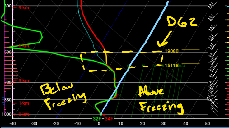
Recall that a Forecast sounding or a “Skew-T diagram” (the chart above) is a chart that is on a slant. And you are tracking the red line from the bottom, on the ground, to the top, the top of the atmosphere. And everywhere to the left of the blue line I’ve drawn is below freezing and everywhere to the right is above freezing.
Notice as you go up you fall below freezing pretty quickly and then back above freezing again, then back below freezing.
The dashed area is the DGZ, the Dendritic Growth Zone, that is where the atmosphere is making snowflakes. And since there is a patch of the atmosphere below that above freezing, that means the snow will melt before reaching the ground.
The NWS up in Jackson made this cool graphic to help explain too.

Farther south, the atmosphere won’t be quite as chilly.

Notice that the atmosphere is above freezing from about 3Km (~9,000ft down). That means it will just be a really chilly rain.
The precipitation will be light and last until about 9p tonight. And the ground is so warm that any frozen precip that mixes in with the liquid stuff won’t impact travel at all.
After the precipitation ends, then it turns plain chilly and breezy.
Day to Day Forecast
Today
Cloudy and breezy. Showers again this afternoon and evening. Some rain showers may mix with ice pellets near the I-20 corridor. Highs in the upper 60s this morning and cooling down all day long. Northwest winds 5 to 10 mph increasing to 10 to 20 mph with higher gusts in the afternoon. The chance of rain 60 percent.
Tonight
Mostly cloudy. Much colder. Breezy. Lows around 30. Northwest winds 10 to 15 mph. Gusts up to 25 mph in the evening. Wind chill values will be down in the low to mid 20s overnight.
Monday
Sunny, cooler. Highs around 50.
Monday Night
Mostly clear. Lows in the upper 20s.
Tuesday
Sunny. Highs in the upper 50s.
Tuesday Night
Partly cloudy. Warmer. Lows in the lower 40s.
Wednesday
Partly cloudy. Warmer. Highs in the upper 60s.
Wednesday Night
Partly cloudy with a 20 percent chance of light rain. Lows in the upper 40s.
Thursday
Mostly cloudy with chance for showers. Highs in the lower 60s. The chance of rain 30-percent.
Thursday Night
Partly cloudy. Colder. Lows around 30.
Friday
Sunny, cooler. Highs in the lower 50s.
Friday Night
Mostly clear. Lows in the mid 30s.
Saturday
Partly cloudy. Warmer. Highs in the mid 60s.


