Hey y’all. I wanted to start off by saying I hope that everyone is safe and healthy this morning. It has been a wild few days across the Southern Mississippi area, so it’s worth taking a look at.
It seems like a large section of the I-20 corridor went under a Flash Flood Emergency at some point yesterday, especially including Jackson and Morton. For those of you in Southeastern Mississippi, it may not have been quite as bad, but this has still been quite an impactful event.

This map is a rain estimate for the past 7 days. This is just an estimation, but multiple records were set across the state for wettest August on record. This was well forecast, but it’s still unfortunate to see it play out.
With the rainfall being so heavy, many of the local streams and rivers are now forecast to go into minor or moderate flood stage over the upcoming days.

More detailed forecasts can be found at the NWS page, but we’re looking at most of the rivers in our area going into flood stage. The orange dots are forecast to go into the Minor flood stage, and the red dots might see Moderate flooding.
And, of course, one of the big stories was the Hattiesburg potential tornado/landspout that occurred yesterday. Those weak circulations are somewhat common in the Summer, and we did see one earlier in the year as well. They aren’t easy to detect, but hopefully no damage was done. It appears that this is the case, thankfully.
Moving on to the actual forecast, the flooding threat is unfortunately set to continue. Rainfall should still linger across the area, albeit less frequent.

Storms are expected to form this morning, and should expand in coverage during the day. The hopes are that not everyone will see rain, but the chances are pretty good for some heavy rain.
Severe weather is generally not expected, but like we saw yesterday, it’s impossible to completely rule out. We should have widespread cloud cover, limiting our temperatures, thus lowering the amount of energy we can get for storms.
If there was any sunlight, a lot of the solar energy would go into evaporating water instead of warming the air, so the high temperatures wouldn’t be too high anyway. All of this is just to say that today is probably going to be pretty cool, and pretty cloudy.
With PW values over 2”, the atmosphere is still primed for heavy rainfall.
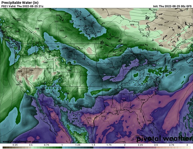
Though not as excessive as the past few days, these values are still pretty high, and can absolutely lead to heavy rainfall. For this reason, the entire area is under a Slight Risk of flash flooding for today.
This is a downgrade from the Moderate Risk we were in yesterday, but it won’t take much rain to cause flooding so we all have to be super cautious around some of the lower-lying roadways and areas around creeks and rivers.
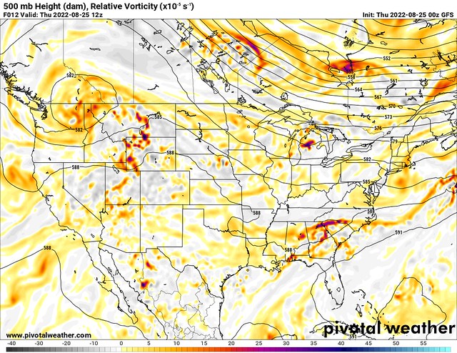
This morning, the main chunk of vorticity that caused the worst of the rising motion, leading to rain, is being pushed out of this area. While this method of forcing is exiting, all this means is that we probably won’t be seeing the widespread, long-duration rains anymore.
There will still be storms that occur, but the upper-level pattern isn’t quite as conducive.
Moving ahead to Sunday, we do have some upper-level ridging pushing back into the area, though disturbances will still roll around the side of the ridge.
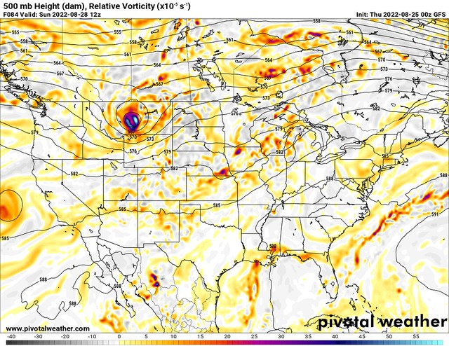
This does show a disturbance moving through around Sunday morning, and rain chances will continue throughout the rest of this forecast period. The ridging will cause some sinking and drying air, which should lead to more sunshine in the later half of this week into the weekend.
Sunshine would be great, given the dreary conditions that have been plaguing the Southeastern US. Here in Monroe, LA, it’s been dreadful and rainy all week too, so I’m so ready for some sunshine.
The 3-day rainfall forecast shows much lower values than we’ve seen, so this is a welcome change. 1-2” in 3 days is still not great, so flooding will likely occur in some areas. One bad thing about the upper level winds moving out of the area is that storms are going to slow down, and could stay over a site for a long time. It’s all worth keeping an eye on.
It’s only fitting that my last week here is one of the more eventful. School is starting up, and things are getting busy, and between homework and my job, I can’t make a separate tropical outlook.
Word of advice? Try to ignore all the model runs that show hurricanes in 2 weeks. I promise that we will let you know if something serious comes up. Don’t trust your cousin’s coworker’s kid on Facebook. Nick keeps up with everything and won’t let anything slip through the cracks.
I’ll be back for one final forecast this Saturday. Until then, good luck staying dry!
Day-to-Day Forecast
Today
Mostly cloudy with an 80-percent chance of thunderstorms. Highs in the low-80s. Heavy rain and flooding may occur.
Tomorrow
Mostly cloudy, with a 70-percent chance of thunderstorms, especially in the afternoon. Highs in the mid-80s.
Saturday
Partly cloudy, with a 70-percent chance of afternoon thunderstorms. Highs in the upper-80s.
Sunday
Partly cloudy, with a 70-percent chance of afternoon thunderstorms. Highs in the upper-80s.
Monday
Partly cloudy, with a 60-percent chance of afternoon thunderstorms. Highs around 90F. The Heat Index may reach 103F.
Tuesday
Partly cloudy, with a 70-percent chance of afternoon thunderstorms. Highs around 90F.
Wednesday
Mostly sunny, with a 60-percent chance of afternoon thunderstorms. Highs around 90F.


