Hello everyone, there will be another round of storms will be developing near the coast as the low-pressure system slowly moving to the east. In the morning, In the morning, it will be mostly cloudy with a chance of morning showers brewing up near the coast with a low temperature in the 70s. In the afternoon and evening, there will be widespread thunderstorms and showers will be appearing in the coast with a high temperature in the low 80s. The dew point temperatures will be in the mid 70s up to upper 70s.
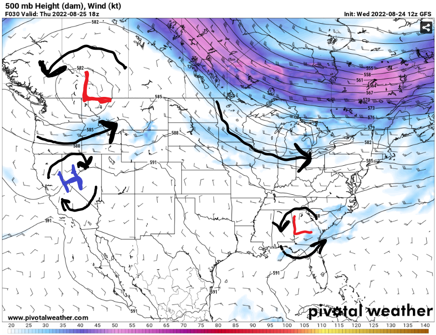
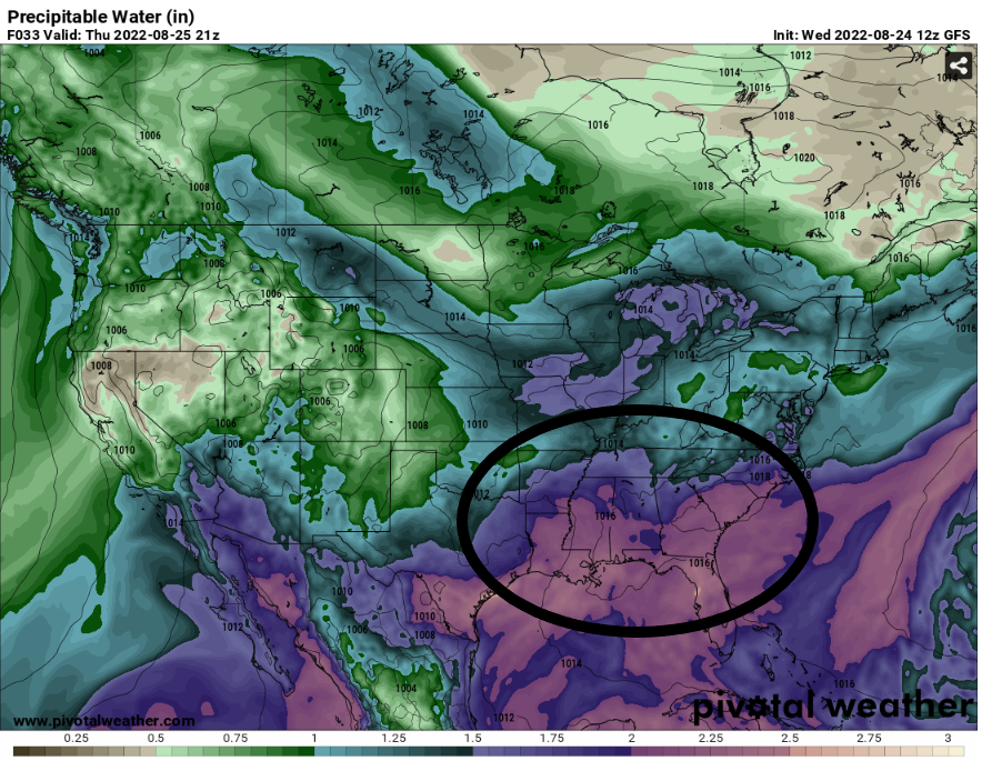
There will be multiple signs of having a widespread heavy rainfall will be happening for the coast. There will be a low-level pressure still moving along the coast to help development of the storms throughout the day. With a strong south to southeast winds move ample amount of moisture from the Gulf of Mexico to have high dew point values in the coastal areas. The next factor will be the precipitable water values will be ranging from 2.25 to 2.4 inches for entire parts of the coast. These factors will be having a widespread rain event will developing in the late morning to the evening.
Here is a HRRR visualization of the radar for multiple rounds of storms will be going through the coastal areas. Most of the heavy rainfall will be happening in the Mississippi and Alabama coastal areas. It going to be another wet day, but the temperatures will be nice and cool.
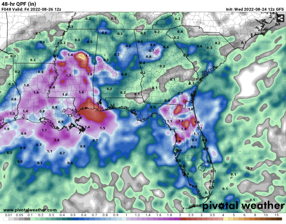
48 Hour QPF // Courtesy: Pivotal Weather 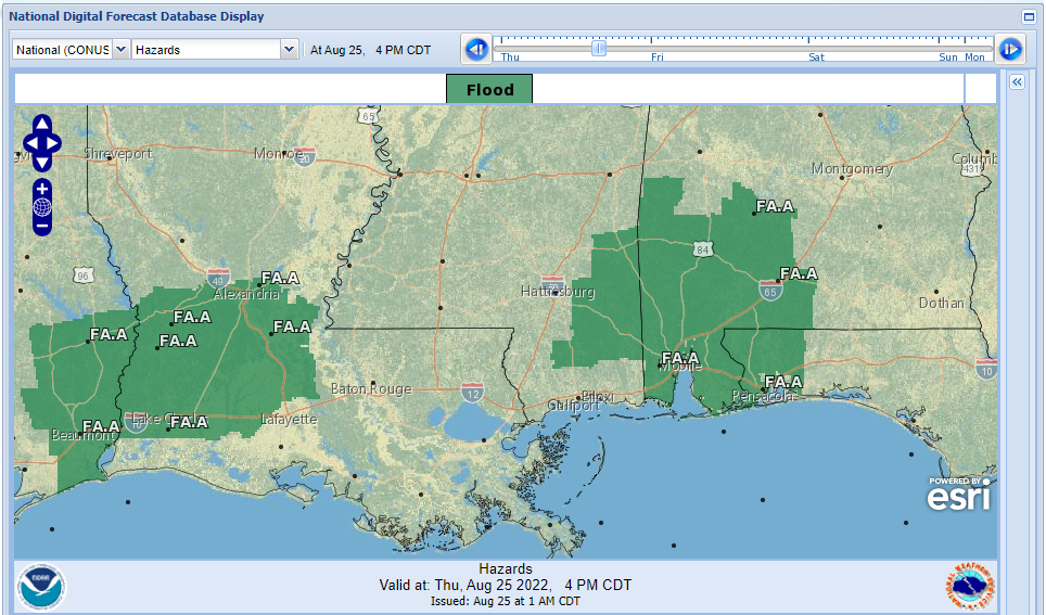
National Digital Forecast Database (Hazards) // Courtesy: National Weather service
In Louisiana, Mississippi and Alabama coast will be the hardest impact for heavy rainfall. The GFS model estimated Thursday rainfall for the coast will be at 1 inch up to 3.5 inches of rain on Friday Morning. In Alabama and Mississippi coast will be under a flood watch till late in the afternoon. The reason for the flood watch for those areas because the soil is so saturated from multiple days of rainfall and more rain is on its way for today. Be careful, for any possible flash flooding for today as the storms coming through your area.
Day to Day forecast
Thursday
Mostly cloudy to early morning showers with a 100 percent chance of widespread showers and thunderstorms in the afternoon and evening. With a high temp in the low 80s and a low temp in the low 70s. A light south to southeast wind from 5mph up to 10 mph.
Friday
Mostly cloudy, with a 80 percent chance of widespread showers and thunderstorms in the afternoon and evening. With a high temp in the upper 80s and a low temp in the low 70s. A calm wind to 5mph to the south.
Saturday
Partly cloudy, with an 80 percent chance of widespread showers and thunderstorms in the afternoon and evening. With a high temp in the upper 80s and a low temp in the low 70s. A calm wind to 5mph to the south.
Sunday
Partly cloudy, with a 60 percent chance of scattered showers and thunderstorms in the afternoon and evening. With a high temp in the upper 80s and a low temp in the low 70s. A calm wind to 5mph to the south.
Monday
Partly cloudy, with a 60 percent chance of scattered showers and thunderstorms in the afternoon and evening. With a high temp in the upper 80s and a low temp in the low 70s. A calm wind to 5mph to the southeast.
Tuesday
Partly cloudy, with a 60 percent chance of scattered showers and thunderstorms in the afternoon and evening. With a high temp in the upper 80s and a low temp in the low 70s. A calm wind to 5mph to the southeast.
Wednesday
Partly cloudy, with a 50 percent chance of scattered showers and thunderstorms in the afternoon and evening. With a high temp in the upper 80s and a low temp in the low 70s. A calm wind to 5mph to the southeast


