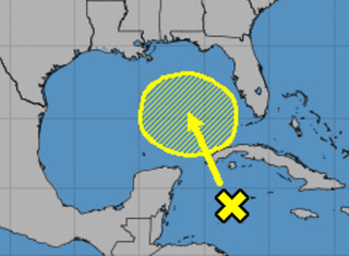
The National Hurricane Center has updated their forecast to include an area of interest in the Gulf of Mexico. The NHC also gives this area a 20-percent chance of development.
The National Hurricane Center Forecast reads as:
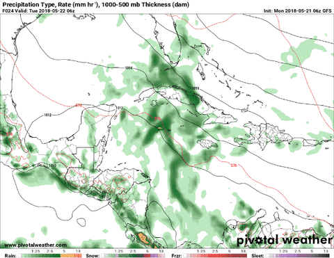
Widespread cloudiness and showers extending from the northwestern Caribbean Sea across Cuba and the Florida peninsula are associated with the interaction of a large upper-level low with a weak surface trough. While environmental conditions are expected to be unfavorable for development during the next couple of days, some gradual development is possible later this week while the system moves into the central or eastern Gulf of Mexico. Regardless of development, locally heavy rainfall is possible across western Cuba and Florida over the next several days. For more information on the heavy rain threat, please see products issued by your local weather office. The next Special Tropical Weather Outlook on this system will be issued by 800 PM EDT tonight.
Keeping with the tradition of last year, before you get too concerned, here is an objective look – in plain English – at the storm and what you need to know about it. Here is a #nofilter look at everything about this potential system. Still borrowing a line from former United States Secretary of Defense Donald Rumsfeld, we are going to look at the known knowns. The known unknowns. And the unknown unknowns.
Known knowns
There is an area of storms in the Caribbean Sea that continues to get better organized. And forecast models suggest it may develop into a more organized system by later this week.
Outside of that, the waters in the Gulf of Mexico are already pretty warm.
Doesn’t take long in mid-May to warm the Gulf of Mexico sea-surface temperatures. Week-on-week increases of 1°-2°C in the Central Gulf where tropical disturbance will track. Not expecting a well-organized system but heavy rainfall. SST 26-28°C: pic.twitter.com/h2WbYfNVPZ
— Ryan | weather.us (@RyanMaue) May 21, 2018
Sea surface temperatures are running between 77F and 83F. That is enough heat – generally – for tropical system development and organization.
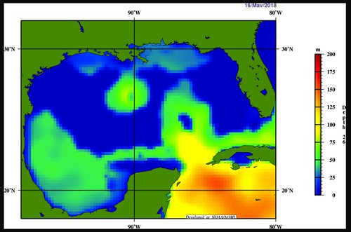
That said, the 26C Isotherm (I’ll have a write up about why this matters at some point soon) isn’t terribly deep across the Gulf. The Loop Current is starting to get moving as there is a bulls-eye of slightly warmer water off the coast of Louisiana, but in general, there isn’t anything crazy-out-of-the-ordinary warm right now.
Briefly, the 26C Isotherm is important in determining the overall heat content available for tropical systems. The deeper the isotherm, the more warmer water there is available for these storms to use to grow and organize. When the isotherm is shallow, it means there isn’t as much warm water, and thus, it may be more difficult for a tropical system to organize.
I always liken it to making a turkey sandwich. If you are really hungry, do you want a sandwich with one slice of turkey? Or 10 slices of turkey? The same rule applies for tropical systems – but instead of turkey, it is warm water. Sea surface temperatures are important, but that is just one slice of turkey. It is important to see – in essence – how many slices of turkey there are out there.
So, if this system is slow moving if may ‘rain itself out’ of becoming very well organized by cooling the Gulf’s surface temperature.
Known Unknowns
Just how much development and organization is still up in the air. And truthfully, the NHC has only given the cluster of storms a 20-percent chance of development, that isn’t exactly a rousing endorsement for development.
There is also a fair amount of uncertainty about where this thing is even headed. Some models suggest toward Louisiana, others show it toward Florida and Georgia, while others send it out into the Atlantic.
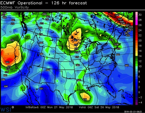
If it slides north toward the Gulf Coast, there is some indication that once it gets there, it may not have anywhere to go. The ECMWF model shows it getting to the Louisiana Coast and stalling out, drenching the area with rain.
Unknown unknowns
Because it is the atmosphere, there are going to be things that are going to happen that we cannot foresee at this time. That is why it is important to be prepared for all possible outcomes. Live along the East Coast? Or along the Gulf Coast? Check your Hurricane Preparedness Kit. Don’t have one? Buy one! Here is a great link for that. There is no need to do much else yet. Check your plan, make sure your kit is ready to go and wait for the meteorological world to figure out what will happen with this thing.
Being prepared today means when it is time to act, you’ll be ready to go!
The Bottom Line
This looks like more of a rain-maker for whoever ends up under it than anything else. Flooding can cause plenty of damage and can be a life-altering event, so please keep an eye on the forecast. That said, this doesn’t have the setup needed (as it appears right now) to develop into a Major Hurricane.
The timeline for this puts it near the United States – and most likely the Gulf Coast somewhere between Houston and Tallahassee – around Saturday morning. And it could stick around through the weekend, making for a very wet Memorial Day weekend for some folks.
I know that is a pretty wide area to highlight, but this thing isn’t even formed yet, and it is very difficult to nail down where these tropical systems are going to go before they even form.
Simply keep an eye on the forecast in the coming days and if you are making plans for Memorial Day weekend, make sure you also have some inside activities planned if you live along the Gulf Coast.


