I hope you’ve enjoyed your Cinco de Mayo! It was a beautiful day outside with hardly a cloud in the sky. Unfortunately for us, Monday will be our best day as the rain will be with us for the rest of the week. Not only that, the NWS in Jackson has already placed us under a Flood watch due to the high volume of rain over the next several days.
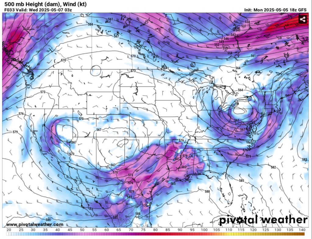
Looking at the upper levels, the Delta block that was mentioned will be overtaken by another trough from the north and will eventually move the trough and combine with it while bringing more southwesterly winds to the upper and mid levels. At the surface, there is a low pressure system building in west Texas that will move towards the Deep South. This will latch on to the low that is already in the Great Lakes region and will eventually stall over the mid-South. What this means is that we’ll get plenty of moisture to work with which will dump a lot of rain over much of Texas to Alabama.
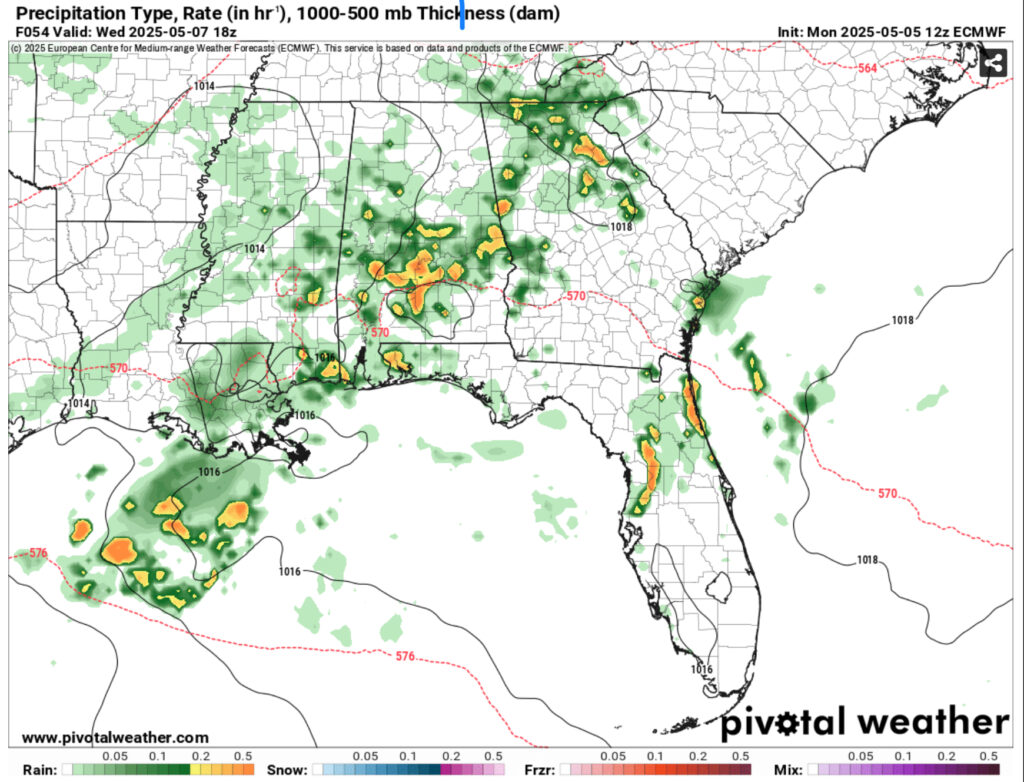
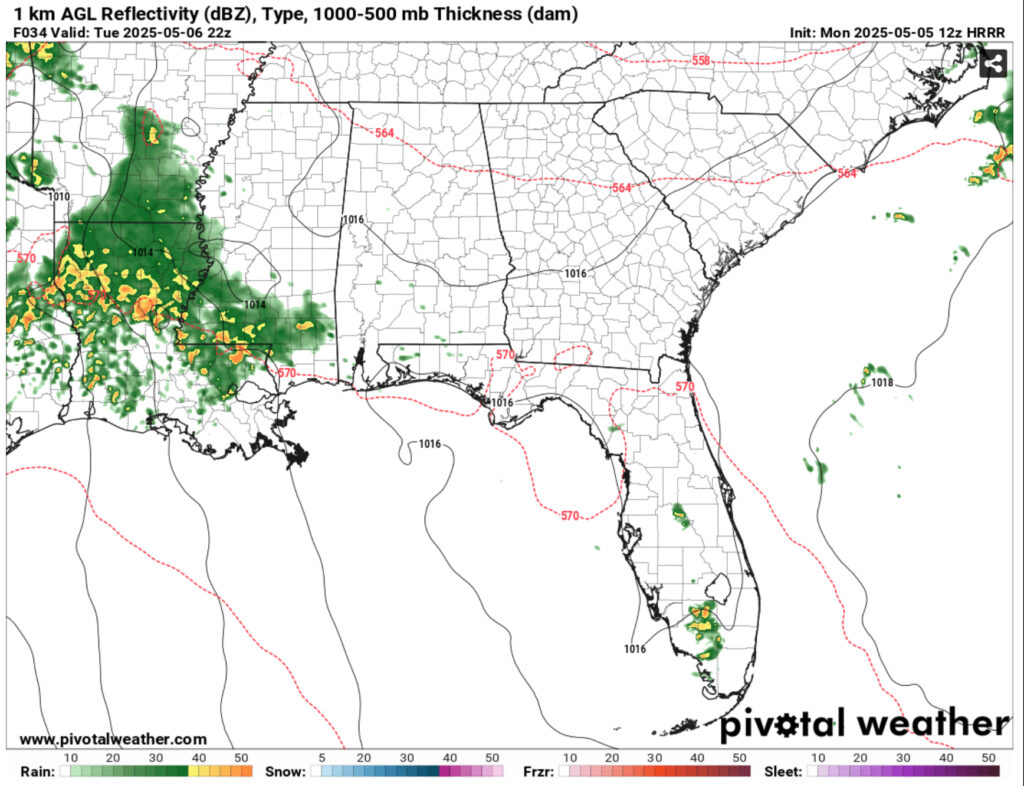
Tuesday will see the first wave of storms develop from the southwest. We’ll see scattered showers in by sunrise, but eventually the bottom will begin to fall out by the early afternoon. Much of this will move in to Louisiana during the overnight hours and expand from I-10 to I-20 during the day.Thunderstorms will bring heavier rain, but expect some localized flash flooding to occur. The line itself will hang around overnight and move further south into southeastern Louisiana and southeastern Mississippi for most of Wednesday. By the end of all this, we could see around 5, and yes, I mean 5 inches of rain within 48 hours, some may even see more depending on the thunderstorms.
Due to a boundary of moisture from the Gulf, we’ll see more rain hit our area Wednesday night into Thursday evening. We can expect another possible inch or two by the time this system moves out. By Friday, we’ll have another chance of thunderstorms possible. This looks to be a bit more spread out across the southeast and diurnal in nature, but with all the rain that we’re expecting, it won’t be much relief in the long run.
The weekend looks to be a similar and due to a developing low out of the Gulf that may be moving inland. This looks to be fairly broad in nature and develops out of northeastern Mexico. Rain chances look to dwindle Sunday and Monday with mixed chances.
Regional Day-to-Day Forecast
Tonight – Mostly cloudy, with a low around 58. Calm wind.
Tuesday – A chance of rain in the early morning, then a chance of showers and thunderstorms in the afternoon. Partly sunny, with a high near 80. Light east wind becoming east southeast 5 to 10 mph in the morning. Chance of precipitation is 60%. New precipitation amounts of less than a tenth of an inch possible.
Tuesday Night – Showers and possibly a thunderstorm. Low in the low to mid 60s. East southeast wind around 5 mph. Chance of precipitation is 90%. New rainfall amounts between 2 and 3 inches possible.
Wednesday – Showers and possibly a thunderstorm. High in the upper 70s. Southeast wind around 5 mph becoming south southwest in the afternoon. Chance of precipitation is 90%. New rainfall amounts between 1 and 2 inches possible.
Wednesday Night – Showers likely and possibly a thunderstorm. Mostly cloudy, with a low in the low to mid 60s. South wind around 5 mph becoming calm. Chance of precipitation is 60%. New precipitation amounts between a quarter and half of an inch possible.
Thursday – Showers and possibly a thunderstorm. High in the upper 70s. Calm wind becoming east southeast around 5 mph in the afternoon. Chance of precipitation is 90%. New rainfall amounts between 1 and 2 inches possible.
Thursday Night – A chance of showers and thunderstorms. Mostly cloudy, with a low in the low 60s. South southeast wind around 5 mph becoming calm. Chance of precipitation is 50%.
Friday – A slight chance of showers and thunderstorms, then showers likely and possibly a thunderstorm after noon. Partly sunny, with a high in the low 80s. Calm wind becoming north northeast around 5 mph in the afternoon. Chance of precipitation is 70%.
Friday Night – A 30 percent chance of showers before 1am. Partly cloudy, with a low in the upper 50s. North wind around 5 mph.
Saturday – A slight chance of showers, then a chance of showers and thunderstorms in the afternoon. Mostly sunny, with a high in the upper 70s. Chance of precipitation is 50%.
Saturday Night – A 20 percent chance of showers. Partly cloudy, with a low in the upper 50s.
Sunday – A 40 percent chance of showers. Mostly sunny, with a high near 80.
Sunday Night – Mostly clear, with a low in the upper 50s.
Monday – A 30 percent chance of showers and thunderstorms. Mostly sunny, with a high in the low 80s.


Find it ironic that your name is Noah and we’re talking about flash flooding. Hope you held on to the building plans for the ark.