Over the past week, we have seen relentless rounds of rain in the Southeast as a trough made its way through the eastern US. This pattern, however, is shifting with the appearance of a strong ridge of high pressure building over the central US. Now, most of the Southeast continues to see a rainy pattern but with increased heat and humidity. As a result, some parts of the region will see heat indices well above 100F while other parts of the region stay at or below their average temperatures. This new setup, though, won’t last long either as the active atmosphere seeks a more stable patten.
Starting with today, the high pressure system (clockwise rotation) currently over the south-central US is trying to move eastward. In order to do, it will have to first move northward and cross through the Midwest. This maneuver will be instigated by a low pressure system (counterclockwise rotation) approaching from the North Atlantic which will temporarily push its way into the Southeast on Monday. Due to this dance, the Southeast can expect rain and mostly average temperatures.
On Wednesday, the low pressure system will quickly weaken as it sits over the Gulf of Mexico. Meanwhile, the high pressure system to the north will race through the Midwest, but Tuesday, on its way out, another high pressure system will begin to dominate the West. This setup indicates a new pattern where the east experiences another trough that delivers average temperatures and average-to-above average rainfall.

At the surface, there is another stalled front stretching along the Ohio River. This setup is creating another flood potential for the Ohio River Valley and Mid-South which is indicated by the Weather Prediction Center’s slight risk (2-out-of-4) for excessive rainfall. With rain still in the forecast for tomorrow, there is also another marginal risk (1-out-of-4) for excessive rainfall in the Mid-South and Appalachian Mountains. Kentucky, Tennessee, and West Virginia residents should stay weather aware as more rain is on the way for an already rain soaked region.
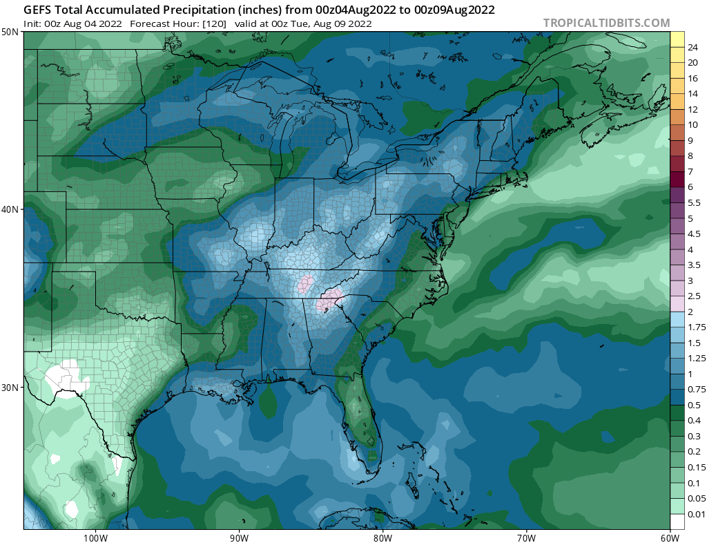

Rainfall accumulation estimates over the next several days show that more rain is on the way for the Mid-South. Locations in the southern Appalachian mountains and the Cumberland Plateau could see upwards of 2″ over the next 4 days. Additionally, in the same timeframe, Kentucky and West Virginia residents could see another 1″-to-1.5″ of rain.
The outlook for next week shows that the rainy pattern will persist for the Mid-South and southern Appalachian mountains. As a result, it is strongly recommended that if you live in an area that has already been flooded, or one that can easily flood, that you start talks with your county emergency manager on what preparations you should be making. FEMA also has some recommendations if you are concerned about flooding in your area.

Over the next week, temperature anomalies show that most of the Southeast will experience temperatures oscillating around the climatological average. However, the Florida Peninsula and the Western Gulf Coast will not be so lucky. By the start of next week, communities within Florida, Texas, and the Lower Mississippi River Valley will see heat indices above 100F with localized pockets approaching 110F. In contrast, from the Mid-South to the Carolinas, most communities will not see heat indices in the 100s due to rain and cloud coverage.


Throughout next week as the upper level trough sets up, a majority of the Southeast will see near normal to slightly above normal temperatures. Most of the above normal heat will be confined to the East Coast, Florida, and Texas. Looking beyond next week, the west-central ridge of high pressure should stay away from the Southeast. Thus, the region’s temperatures will stay status quo with an exception for possible below average temperatures in West Virginia.
Local 3 Day Forecasts (Courtesy: NWS)
| Dallas, TX | Thursday | Friday | Saturday |
| High: | 103F | 101F | 99F |
| Low: | 83F | 79F | 79F |
| Precipitation: | None | 20% | None |
| Atlanta, GA | Thursday | Friday | Saturday |
| High: | 91F | 91F | 91F |
| Low: | 72F | 72F | 72F |
| Precipitation: | 40% | 40% | 50% |
| Houston, TX | Thursday | Friday | Saturday |
| High: | 99F | 91F | 93F |
| Low: | 79F | 79F | 78F |
| Precipitation: | 30% | 20% | 40% |
| Birmingham, AL | Thursday | Friday | Saturday |
| High: | 93F | 93F | 93F |
| Low: | 74F | 73F | 74F |
| Precipitation: | 20% | 70% | 50% |
| Little Rock, AR | Thursday | Friday | Saturday |
| High: | 88F | 91F | 92F |
| Low: | 74F | 75F | 75F |
| Precipitation: | 70% | 50% | 20% |
| New Orleans, LA | Thursday | Friday | Saturday |
| High: | 87F | 89F | 88F |
| Low: | 76F | 77F | 77F |
| Precipitation: | 60% | 50% | 70% |
| Memphis, TN | Thursday | Friday | Saturday |
| High: | 88F | 89F | 92F |
| Low: | 76F | 75F | 76F |
| Precipitation: | 60% | 50% | 20% |


