Looking at the overnight model guidance, things are starting to clear up a bit as to what we may eventually expect in terms of forecast track. But intensity and picking out a specific landfall are still a bit too far out.
Satellite imagery of the overall system has not been impressive, though, at this point, it really shouldn’t be.
You can see that the robust convection from yesterday has ended overnight and there was some interaction from the storms across the southern United States with the outer edges of Invest 92L.
Here is another look on Water Vapor
It is these kinds of mesoscale (small, weather-related) interactions that some of the global models just can’t pick up on. And they can have significant impact down the road.
But, before we get too far, let’s start with the latest from the National Hurricane Center
From the NHC
The forecasters at the NHC bumped the chance for development during the next five days to 50-percent overnight.

Tropical Weather Outlook
Courtesy: nhc.noaa.gov
NWS National Hurricane Center Miami FL
800 AM EDT Sun Jun 13 2021
For the North Atlantic…Caribbean Sea and the Gulf of Mexico:
1. A trough of low pressure continues to produce a large area of disorganized cloudiness and showers over the Bay of Campeche. Slow development is possible over the next several days while the broad disturbance moves little, and a tropical depression could form in this area late in the week. Regardless of development, heavy rainfall will be possible over portions of Central America and southern Mexico during the next several days. Please consult products from your local meteorological service for more information.
* Formation chance through 48 hours…low…10 percent.
* Formation chance through 5 days…medium…50 percent.
Model data

No, not like that. I mean “model” as a noun, not an adjective…

Wrong Data! Weather model data.
Yes. Now as a map!

A useful map…
Thank you!
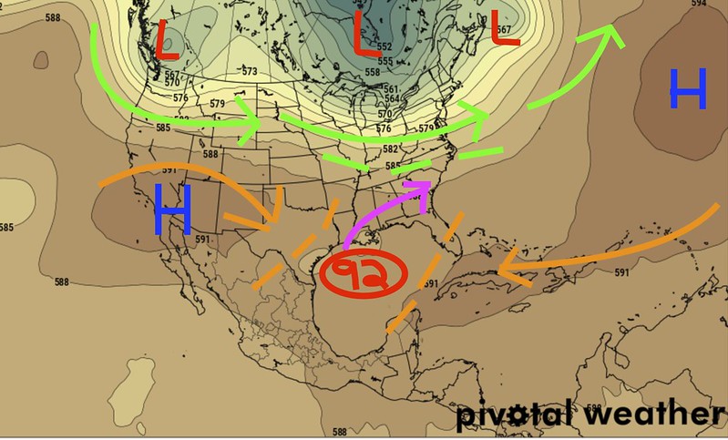
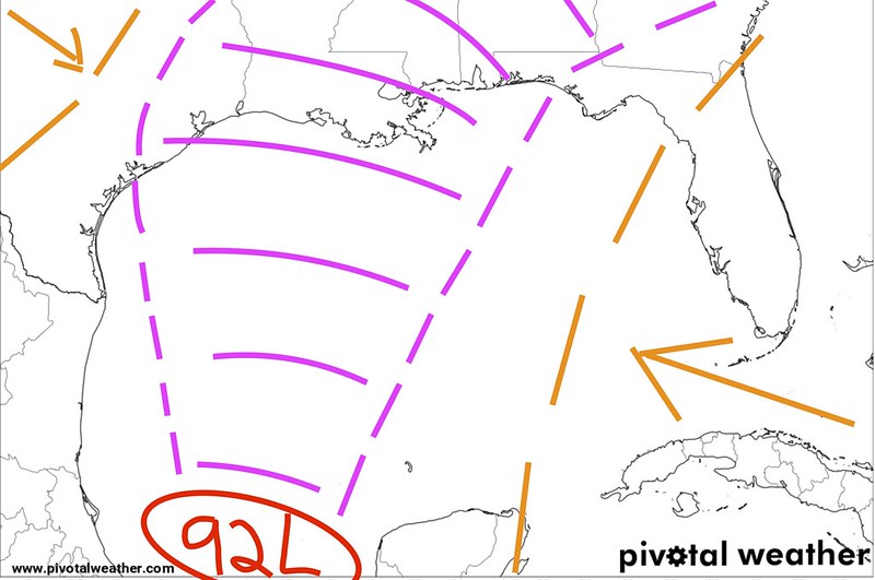
Now that we got that out of the way, the above map is a look at the 00z ECMWF data. This is the newest data showing Invest 92L off the coast still on Saturday evening. I’ve drawn in some of the worthwhile features. The high pressure areas (blue) as well as the mid-level wind associated with those ridges as arrows (orange). I’ve added in some areas of low pressure (red) and the wind associated with those (green) as arrows, too.
The orange lines with no arrows are the sort of fences that the two ridges have built for this system to travel between. Leaving the purple/magenta arrow as the most plausible general track. In this case, I think I turned it to the east too sharply, but you get the idea. The ECMWF thinks the Southeast from about Houston to Tampa is in play.
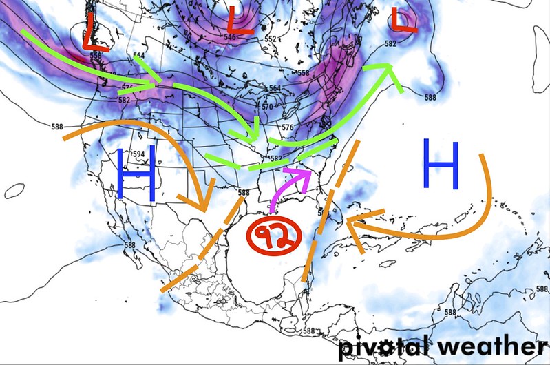
Over on the GFS, things look slightly different.
You may be thinking, ‘Nick, these are, like, the same map…” but there are subtle changes that may mean a lot.
On this map, the same rules apply with colors. But notice that the fence is slanted a bit more north-south. And it is set a bit more too the east. It still leaves the TExas coastline in play – but not as much. And the fence from the north (green) is farther southwest.
That would lead to landfall a bit farther to the east. Sure, Texas coastline is still a possibility, but this looks more like a Louisiana, Mississippi Alabama, Florida problem.
Check them out side-by-side


The big difference to me is that the Euro widens out the ridge over the Rockies but keeps it a bit weaker, while the GFS has a stronger ridge that is a bit more north-south. That difference will change how the edge of the ridge affects the steering flow for Invest 92L.
I briefly mentioned this the other day, but if Invest 92L feels equal forcing between the ridge to the west and the ridge to the east, it may stay put. Or, at the very least, slow down. Now, it will also have to battle Coriolis, but you get the idea.
And that may be why the models continue to push back landfall. Because the “Battle Between The Ridges” (sounds like a great Pay-Per-View bout) is keeping Invest 92L from blitzkrieging northward.
Looking at the global tropical guidance from Tropical Tidbits, you can see that the models are still really struggling.
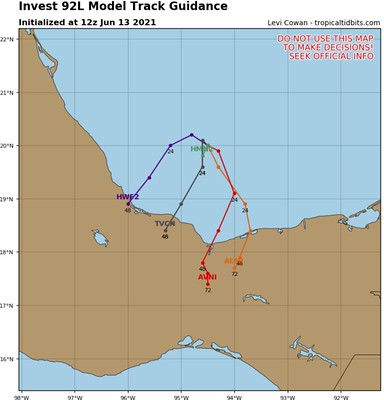
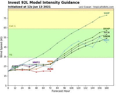
Track guidance is looking out further than 72 hours, and the models take this thing into Mexico. And I don’t like looking at intensity guidance past 72 hours, but as you can see models have it as a Tropical Depression or weak Tropical Storm at that point..
But the models are going to struggle with this until the center of Invest 92 forms.
The Bottom Line
Given that, I tend to think that landfall will be a bit of a blend of the two of those. And I think that anywhere from nearly Corpus Christi, Texas to Panama City, Florida are open to seeing the center of Invest 92L – as probably more than just an Invest – pass nearby.
And I tend to think landfall will happen some time between Friday at noon and Sunday at noon. A wide window for sure. But we have to start somewhere.
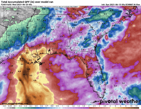
The thing that the models are certain about is that it is going to rain.
No change to the current forecast for the Tropical Threat Index. As the data has not shown any reason to change the numbers.


