The National Hurricane Center is watching a new area of interest in the Gulf of Mexico. This one has been pegged Invest 92L. This one is deep in the bay of Campeche – and may even get some help from an area of interest in the Pacific, too.

This system, Invest 92L, is still more than five days out. Truely, it doesn’t look like it will be creating impacts for the US until late this upcoming week. More specifically, model data suggests that the Thursday / Friday time period would likely be the window of opportunity.
But we will get more into that in a second.
From the NHC

Tropical Weather Outlook
Courtesy: nhc.noaa.gov
NWS National Hurricane Center Miami FL
200 PM EDT Sat Jun 12 2021
For the North Atlantic…Caribbean Sea and the Gulf of Mexico:
1. An area of cloudiness and showers over the Bay of Campeche and the adjacent land areas is associated with a trough of low pressure. Slow development of this system is possible over the next several days as it moves slowly and erratically, and a tropical depression could form in this area by the middle of next week. Regardless of development, due to the slow motion heavy rainfall is possible over portions of Central America and southern Mexico. Please consult products from your local meteorological service for more information.
* Formation chance through 48 hours…low…10 percent.
* Formation chance through 5 days…medium…40 percent.
History
Historically early-season storms that form in the Bay of Campeche don’t turn into Major Hurricanes.

Inf act, looking back, 1934 and 1957 were the only two years that featured a hurricane come through this area and be stronger than a Category 1 Hurricane.
So the while it is possible, it is not very likely at all.
Often these storms are one-sided rainmakers. In fact, if you slim the available years down to 1990 through 2020, the only landfalling tropical systems from this area to impact the US Gulf Coast are Arlene in 1993 and Cristobal in 2020.
Before you write this one off, though, the model data shows that whatever it out there will be impacting someone along the US Gulf Coast by the end of next week.
Water Temperatures
Looking out into the Gulf at the surface temperatures, Heat Content, and 26C isotherm, we can get a good idea about how much “food” this thing will have to eat.


One quick note, I don’t often show Gulf surface temperatures (left) because they don’t really matter. A lot of times people ask, “what is the Gulf temp?” and the answer is always, “very warm.”
A better way to know if the waters are capable of sustaining a tropical system, though, you need to look underneath the surface. Because once it starts raining for an extended time in an area, it starts to ‘turnover’ the water. All of the rain-cooled water starts to sink and the water under it rises (water works like air, in that the warmer stuff rises).
So looking at the Tropical Cyclone Heat Potential (middle) is usually more useful because it looks at the depth of the 26C isotherm and takes into account sea surface temperatures and kicks out a number that is in kiloJoules. Helpful!
But, for me, there is nothing better than the simple 26C isotherm map (right). That will tell you how far down you have to go to get to 25.9C. Why is that important?
Model Data
Taking a quick peek at the track & intensity guidance, you can see that things are still rather uncertain. These are not the typical graphics from Tropical Tidbits. These are pulled from University of Wisconsin at Milwaukee.
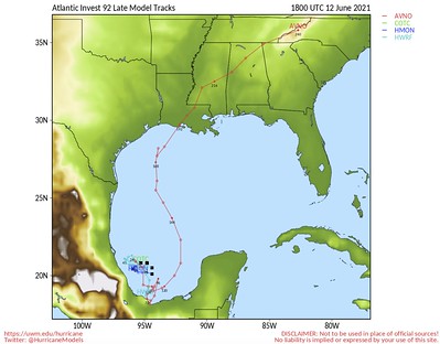

We’ve been keeping tabs on this for the last few days and models continue to struggle with the evolution of Invest 92L. That is par for the course with these early season systems.
A quick aside… The global models (GFS, Euro, Canadian) aren’t higher-resolution enough to pick out the – at times mesoscale – triggers that lead to these early season storms. Plus, because these are often slower to develop, sloppy, and one-sided the models struggle to offer an accurate portrayal of the eventual system.
All of that being said, these models are the best we can do. And, over the years, the more you watch models do the things they do, you eventually pick up on hidden nuggets within the data that can tell you more than the actually data that is being displayed on any given map.
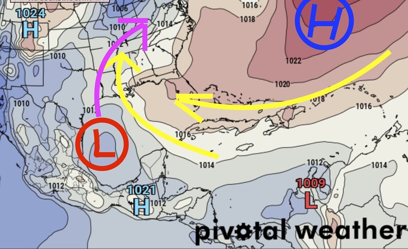
The general setup is that there is a ridge to the east and this little area in the Bay of Campeche. If you read my update the other day, the same general pattern is going to be present. and it will be a question of (1) just how much the ridge of high pressure pokes into the Gulf, (2) how organized this thing becomes, and (3) where the ridge is to the west
Starting with the European model, The data that has come down today continues to show more of a Texas landfall. It has the system reasonably organized (perhaps Tropical Storm strength?) with a more stout ridge of high pressure in the Atlantic shoving the system more northerly.

And, in fact, the data today increased the strength of the ridge at the surface pushing the potential landfall even farther west.
Conversely, the GFS shows the system closer to the central Gulf with a landfall more likely for Louisiana and Mississippi.

So what gives? Which one is right?
Well, neither are “right” I can tell you that. But the reason one has the system in the center of the Gulf and the other has one toward the west is due to the difference in the strength of the ridge in the Atlantic.
This is probably tough to see on the maps, but there is a little line that has a “1016” on it, on all three maps. That line is basically “connecting the (invisible) dots” between all of the points on the map that have a surface pressure of 1016 millibars. Looking at that line is a good way to estimate how strong the ridge is. The farther west that line is, the stronger the ridge is, the farther east, the weaker.
The Euro shows that line farther west. The GFS shows it farther east.
But again, neither is “right” but I would lean toward the Euro at this point. I think the GFS model does some pretty odd things with Invest 92L between now and Thursday. It has it do a cartwheel in the Gulf, for example. That just doesn’t seem likely.
That said, I tend to think that the Euro may be a bit too far to the west. If Invest 92L does start to lift north, the influence of the ridge to the east won’t likely be as pronounced as shown in the guidance. On top of that, the other ridge back to the west (in the Rockies) may be a bit wider and may play more of a role in the eventual movement of Invest 92L.
And if that is the case, it may stall out in the Gulf for longer or simply just move slower. But time will tell. For now, I don’t think we have enough information to offer very many specifics.
The specifics I can offer:
Thanks, Ollie.
Model guidance has been pretty adamant about that. The 12z Euro today pegged a bullseye of almost 40″ of rain during the next 10 days – most of that from Invest 92L – across south central Louisiana.

The Bottom Line
Not too much we know right now about specifics. All we know is that now is the time to keep tabs on the forecast. And now is the time to double-check that Hurricane Preparedness Kit.
While this system is unlikely to be a Major Hurricane, it isn’t completely out of the question. More likely though is that this thing will be quite the rainmaker wherever it goes. And the Gulf coast is already pretty damp. There aren’t too many places between Corpus Christi and Tampa that can handle much more rain at this point.
So this may end up being more of a flooding storm than a wind storm or surge storm.
On the Tropical Threat Index, is is showing a 3.33. With a Wind threat of “1” and a Surge threat of “1” and a Rainfall threat of “3” at this point.

This threat level would be comparable to to Tropical Storm Cristobal of 2020 and just below Hurricane Zeta of 2020. The difference, though, is that Cristobal was less about rain and had a bit more surge. Zeta was a wind maker.
For more information on how I got that number, check this out!
For now, no reason to worry too much. Please keep checking in on the forecast as we do our best to keep you ahead of the weather.


Wow. Great job Nick. Your teachings helped me to understand what you’re saying. Thanks a million for the report.