I’m no Herbert Saffir or Robert Simpson, but I do like thinking outside the box and challenging myself with trying to find order in chaos. Truly, I think that is why I love meteorology so much, every day is a puzzle.
Today’s puzzle actually started back in 2014. And really started back in 2012. When I thought that there had to be a better way to communicate the overall potential of the different threats from a landfalling tropical system. Not from a “help people understand what actions to take” but rather from a “encourage people to actually take some sort of action” at all.
DISCLAIMER: This is not scholarly research. Nor is this intended to replace the Saffir-Simpson scale. This is the first attempt by a regular human to build a more all-encompassing categorization of tropical systems and the impacts the storms have on land.
You may see some number crunching in here and find yourself asking, “well, why did he do that there?” and I may not provide a reason directly. But know that, since this isn’t a scholarly article, I did allow for some fuzzy edges on some of the mathematics
Why do this?
A great question.
From what I’ve witnessed over the years, often times inaction is the Number One problem with landfalling tropical systems. That inaction has been curtailed in recent years given how many Major Hurricanes have made landfall, but it is still an issue.
So I wanted to give people a number they could grab ahold of that would – hopefully – encourage them to actually do something. If a Tropical Storm is moving toward a person, they may be less likely to act than if a Category 4 Hurricane were coming. But what if that Tropical Storm was designated as a “Threat Level: 3” storm, instead? While the Category 4 Hurricane was a “Threat Level: 5” storm.

Now the difference between the two systems on the impact over an area doesn’t seem as far apart.
Under my Tropical Threat Index, that is the difference between a landfalling Hurricane Dennis in 2005 and Tropical Storm Cristobal in 2020. Dennis cause $2.5 Billion in damage, while Cristobal cause more than $650 million. Dennis killed 15 people in the United States. Cristobal killed 6.
Another Threat Level: 5 storm was Hurricane Delta in 2020. That storm cause about $2.1 Billion in damage. And killed 6 people.
So the Tropical Threat Index does align different tropical systems up with each other in terms of impact reasonably well.
How does it work?
This blends the (1) forecast wind speed with the (2) peak forecast surge and the (3) peak rainfall estimate.
The Wind
The idea is to blend the Saffir-Simpson scale with the EF-Scale a bit, since both were designed – either in part or in total – by engineers surveying damage. But there is a problem since the EF-scale starts at “0” and the Saffir-Simpson starts at “1” so we have to massage the numbers a bit. Plus, given that new research has suggested that the categories for both the EF scale and the Saffir-Simpson scale may be too high to account for the damage experienced, we may also have to massage the numbers.

In this case, I took the range between the EF scale starting at EF-1 (86-110) and the range for a Category 1 Hurricane on the Saffir-Simpson scale (75-95) and averaged those out.
It gives you 91.25mph.
Then, given the new research suggesting that damage may occur at lower wind speed than originally anticipated, I look that number an multiplied it by 80-percent.
It gives you 73mph. do that for the rest of the Categories and EFs and you get
| Tropical Threat Index | Wind Speed Average (mph) |
| 1 | 73 |
| 2 | 90.2 |
| 3 | 108.2 |
| 4 | 130.4 |
| 5 | 143.2 |
At first glance, that seems pretty weighted. The average distance between different Index numbers looks like this
| Tropical Threat Index | Difference in Wind Speed |
| 1 -2 | 17.2 |
| 2-3 | 18 |
| 3-4 | 22.2 |
| 4-5 | 12.8 |
| AVG | 17.55 |
The reason for the weird bell-curve-looking numbers is that by the time you are talking about exceeding 140mph sustained wind, often you are talking about catastrophic damage.
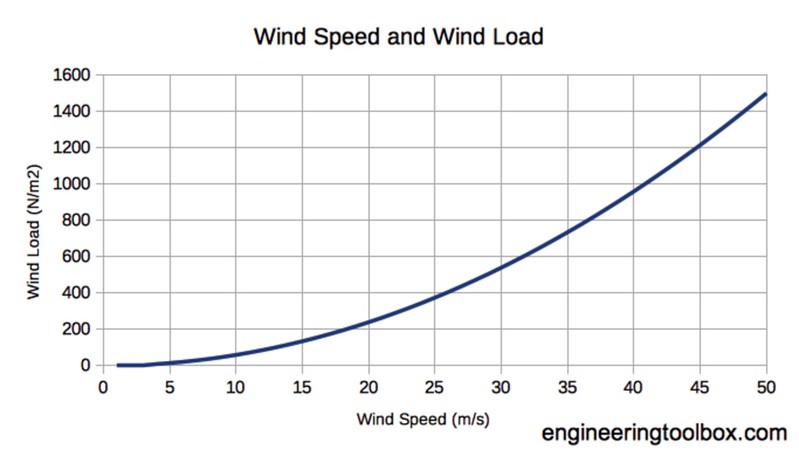
On top of that, if you look at Wind Pressure on a wall along with wind load, you can see that most of the “heavy lifting” for lack of a better analogy, is done in the middle of the curve.

Comparing the above table to the Tropical Threat Index, you can see how the meteorological side lines up with the engineering side.
| Tropical Threat Index | Wind Speed Average (mph) | Wind Pressure (PSF) |
| 1 | 73 | 9.3 |
| 2 | 90.2 | 20.8 |
| 3 | 108.2 | 31.0 |
| 4 | 130.4 | 43.3 |
| 5 | 143.2 | 50.1 |
But we aren’t done yet.
Since both the EF scale and the Saffir-Simpson scale are based on ranges, this Tropcial Threat Index deserves a range, too.
| Tropical Threat Index | Wind Speeds (mph) |
| 1 | 60-79 |
| 2 | 80-99 |
| 3 | 100-119 |
| 4 | 120-139 |
| 5 | 140+ |
Again, because this is a public communication tool, not rooted in the specifics of Civil Engineering, I’ve allowed the scale to represent more arbitrary thresholds of importance than those locked up in XX amount of wind will blow off YY size roof.
Instead, 60mph is the low end because that is the lowest criteria for a Severe Thunderstorm Warning. And since wind damage occurs during straight-line wind from a thunderstorm, and people know that number and have familiarity with it, it is used here.
From there, we had 19mph to get to the top of the first threshold. Then we do it for each Index. Once the wind speed eclipses 140mph, it has reached the top end of the scale.
Surge
A lot like wind, I am not a civil engineer, nor a storm surge expert. However, I did look back through historical data, picking about 20 tropical systems since 2000, at random, to find the peak storm surge. From there, I compared the size and strength of the storm against a few from 2020 to get a good ballpark approximation at a scale.

This was not as involved as the wind. Simply assess those storms and come up with a range based on those average.
| Tropical Threat Index | Storm Surge (ft) |
| 1 | 4 – 7 |
| 2 | 8 – 11 |
| 3 | 12 – 15 |
| 4 | 16 – 19 |
| 5 | 20+ |
This scale should work well. A 4′ to 7′ surge in most areas is going to be a bit more than nuisance flooding and will likely inundate some homes. And 20′ of water is going to be catastrophic.
While storm surge of under four feet may still cause damage in some places, in this particular scale, it was omitted.
Rainfall
The difficult part about calculating rainfall for an impacts index is that the impacts of rainfall are going to be dictated by recent climatological conditions and topography. Has it been dry? Wet? Is it peak growing season? Late Spring? Early Fall? On a hill? In a valley? Coastal Plain?
That said, given the climatological data for the Gulf Coast and southeast Atlantic coast, I think this scale is a good starting point.
| Tropical Threat Index | Rainfall (in) |
| 1 | 3″ – 5″ |
| 2 | 6″ – 8″ |
| 3 | 9″ – 11″ |
| 4 | 12″ – 15″ |
| 5 | 16″+ |
Pretty straight-forward. I’m thinking that any place that picks up more than 16″ of rain from a single event is going to be in pretty high water. While 3″ isn’t going to cause many problems outside of small creek flooding and impassable roads.
Putting the three together
Yeah, we’re not done doing math yet. But this part is easy.
Take each Tropical Threat Index number from each threat and add it together. For example, wind at 120mph, 8ft of surge and 12″ of rain? That is a “4” a “2” and a “4” on each scale. A total of 10 out of 15. But a scale of 15 isn’t very easy to digest for most people.
Things “out of” numbers like “3” or “5” or “10” are the easiest to follow.
So, divide the number by 1.5 to put it on a scale out of 10. And you get 6.67. Round up! And your hypothetical hurricane with winds at 120mph, 8ft of storm surge and 12″ of rain is a “Threat Level 7”

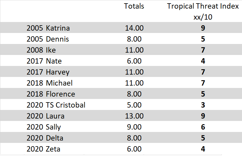
A hurricane from the past that was also a “Threat Level 7” was Hurricane Ike in 2005.
Other random named storms from other the years and their threat level…
Elaborating for the Nay-Sayers
But Nick, “Threat Level 7” doesn’t tell anyone what to prepare for!
It does not. This scale is about engaging people, getting their attention and encouraging action. It does not give people any clues as to what action to take. There isn’t a silver bullet in weather communication.
But Nick, “Threat Level 7” could be confusing since the number take three different threats into account. What if this one is a 7 with more wind, and the last one was a 7 with flooding and surge?
This is about action, not about communication of specific risks. A threat that is a “7 out of 10” would hopefully get someone to pay attention and take appropriate action. However, I know many times during the past few years where I’ve had to tell people, “This is a category 1 hurricane, but don’t pay attention to the wind, we are more worried about the rain!” Or “This is a Category 5 storm, but it won’t have much surge, it will be all wind”
Because tropical systems are multi-faceted events, there is never going to be a single scale that will be able to communicate all of the potential risks. However, often times low-end tropcial systems like Tropical Depressions, Tropical Storms and even Category 1 Hurricanes are often overlooked because they don’t grab anyone’s attention.
In this case, a Tropical Depression with 20″ of expected rainfall would still land as a “Threat Level 3” instead of, what most people would think, “no threat” since it was the lowest end of the tropical system scale.
But Nick, this is just going to confuse people more! We don’t need more scales, we need fewer scales!
I agree, this should replace all other scales. The ease of each individual scale being out of five is on purpose. Plus, if this is the only scale, then people wouldn’t have to be confused anymore.
Nick, why do you think you’re so smart? Just leave this to the experts!
Again, I want to reiterate that I have no significant expertise in engineering, social science, or tropical meteorology. I’m just a guy, who does meteorology for a living, with a blog and an idea. I’m not saying the way we do things is wrong or terrible. But it can be better. And I’m not saying my idea is perfect or the only idea, it just seems easier to digest.
The Bottom Line
This is an idea. Not a perfect idea. Not the best idea. Just an idea.
The goal would be to better communicate risk to the public and create a better way to convey the potential impacts for a given area.


