Sometimes I’m not sure if certain people commenting on my facebook videos are dropping ‘hot takes,’ just there to be rude, or genuinely frustrated because they actually don’t understand what I am trying to explain.
On the flip side, I see many people posting that they now expect to see snow simply because I said it was being shown as a possibility within the model guidance.
So, everyone buckle up. We’re going to a fun sciencey ride!
The model data continues to show the chance at wintry precip from Texas to Georgia next week, but before you get too excited, I want to try and better explain what I was getting at in my video last night to help give you some background as to why the potential, in this particular case, remains as a potential but isn’t necessarily worth betting on to happen.
Quick notes on the Polar Vortex
I promised myself I wouldn’t get too deep into the weeds with this, so this will be quick. I promise.
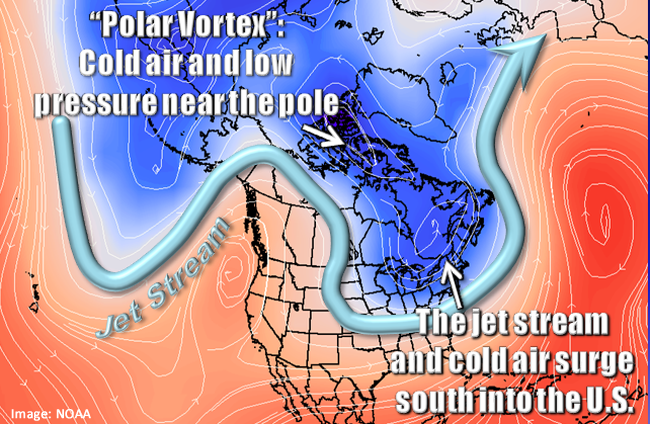
The Polar Vortex, according to the National Weather Service, is best described as “a large area of low pressure and cold air surrounding both of the Earth’s poles.” It is always there. all year, all the time. The northern Polar Vortex gets weaker in the summer when it is warmer and stronger in the winter when it is cooler.
From the NWS:
Many times during winter in the northern hemisphere, the polar vortex will expand, sending cold air southward with the jet stream (see graphic above). This occurs fairly regularly during wintertime and is often associated with large outbreaks of Arctic air in the United States. The one that occurred January 2014 is similar to many other cold outbreaks that have occurred in the past, including several notable colder outbreaks in 1977, 1982, 1985 and 1989.
weather.gov
Ghost ride the whip
I’m betting Mistah F.A.B. never thought that his 2006 single – that was pulled from the airwaves due to copyright concerns – would be used by a meteorologist to explain the Polar Vortex…. But here we are.
Remember when you were a kid and you would ‘ghostie’ your bike? Ride really fast, jump off and let’er ride?
Exactly! Through a mixture of forward momentum, gyroscopic motion, balance, and smooth surfaces, the bike would travel on its own, with no one on it, for a certain period of time.
And when you first get off of the bike, because there isn’t much of a wobble to the tires, the handlebars are still pointing straight ahead, and the pavement is smooth, you have a pretty good idea that in the first 20 feet (or so) the bike will go in a mostly straight line.
But the moment you start to get any lean in the bike, or that front wheel starts to wobble, your ability to accurately project where the bike will go during the following 20 feet gets reduced – drastically.
Another way to think about it is if you are producing a forecast for the bike, when everything is smooth, straight-forward, and without wobbles the forecast is easier.
When you are forecasting something with bumps, a lean and many wobbles, it becomes more difficult.
Back to the Polar Vortex
Forecast models that meteorologists use take that Polar Vortex into account. And when it is smooth and straight-forward, the forecast for – literally – everything else is easier for the models to handle.
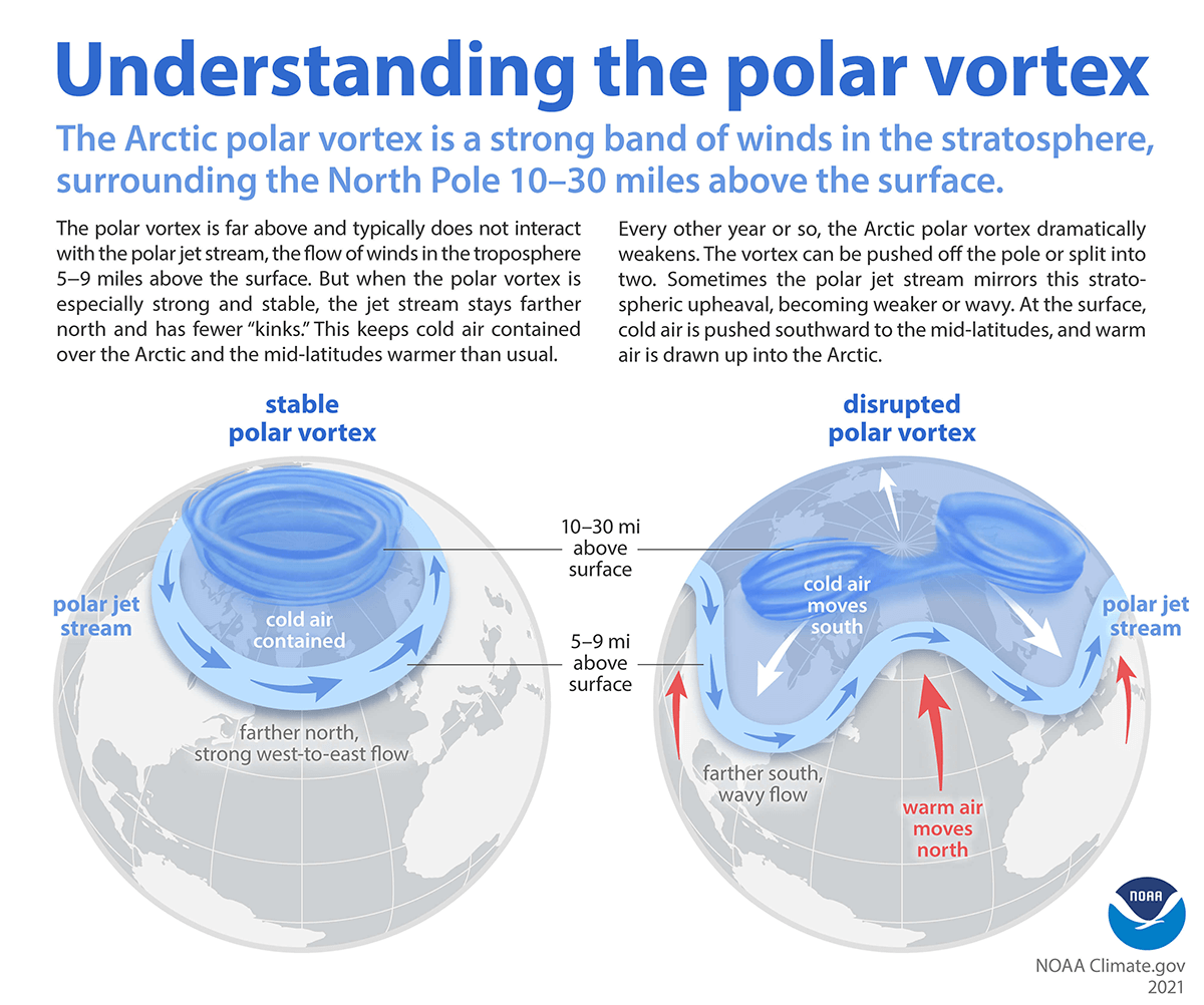
But when it gets wobbly it gets more difficult for the models to produce an accurate representation (forecast) of the data further into the future.
Just like ghostie’ing your bike.
Explaining the model data
Throwing another stick between the spokes (bike puns!) is the fact that when the models are trying to produce forecast data, they are doing do without all of the actual information to begin.
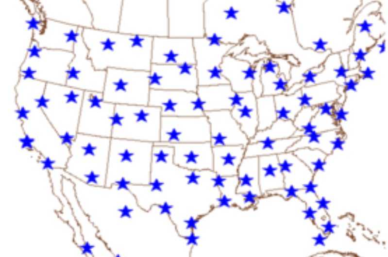
The above map shows all of the places where the National Weather Service releases weather balloons. These weather balloons take temperature, pressure, wind and humidity readings while they float all the way up through the atmosphere. This data is very – VERY! – important for many reasons. In this case, it is important because this data gets fed directly into the weather modeling as a starting point.
Because if we don’t start with accurate data, there is no way we will end with accurate data! The ole “Trash in, Trash out” saying applies here.
But, notice that there are many places that do not release a weather balloon. Eastern Oregon, Southern Canada, Sante Fe, New Mexico, in the Gulf, in the cornfields of Iowa, etc.

Since there is no data there, the weather models take in the actual data from where the balloons are launched, and then approximate the data between those points.
What happens when a weird weather pattern develops and there is anomalous cold in one section?

The model has to approximate why that cold is there, and approximate how cold it is between all of the actual data points.
So, going back to our ghostie example. Imagine being blindfolded and then you have to make a forecast for where it will go. Now, if they gave you all of the information about the bike’s movement, at every next millimeter it moved, you may do a decent job.
But, what if all they told you was where the person jumped off, and how fast it was moving. But they didn’t tell you that the front tire was flat and a pedal was missing.
At that point, it may be more difficult to make a prediction.
Now take that you are blindfolded “watching” a bike with a flat front tire, a missing pedal ghostie its way down the road… And add to that, the front tire starts to wobble back and forth, and you need to make a prediction about where it will be in 20 feet.
That is what forecasting next week’s weather for the Gulf Coast is like right now.
Thankfully, we have super-powerful computers to help. And they can crunch all the numbers and make a prediction. But, at some point, there is a place where the forecast becomes, quite literally, unknowable.
But that doesn’t stop the forecast models from trying! Because they are run every six hours. And they will spit out a forecast.
For example, here is the last few days of model data for snow…
And here is the last few days for freezing rain:
These maps will continue to be produced every six hours. Offering a new “solution” each time as the input variables change.
Nick, what’s your point?
So, sure, there is the potential for wintry precipitation. Many of the pieces needed to be in place for wintry precip, look like they will be in place. And, sure, one of these models could be right. But what are the odds? Very low. For now, we just have to play the waiting game.
Because we are blindfolded and trying to predict where a bike with a flat front tire and a missing pedal, is going to be in 20 feet after the wheel starts wobbling back and forth.


2 thoughts on “Polar Vortex induced Gulf Coast wintry weather potential is exactly that – just a potential”
Comments are closed.