We are transitioning out of a highly amplified to more progressive weather pattern across the U.S., but subtropical ridging will continue across the southern U.S. with areas of low pressure situated to its west and east. This will keep above average temperatures in the South and Southeast with cooler temperatures and higher precipitation amounts in parts of the Southwest and Northeast.

Our main areas of concern are 1) a low pressure system over California, 2) a subtropical ridge fixated over southern U.S., and 3) a cut-off low affecting the Northeast. The pacific low is expected to remain over California until Friday when it makes a journey over the subtropical ridge eventually impacting the Plains and Midwest. Our southern ridge will stay put until after the pacific low has moved eastward allowing for the ridge to transition closer to the West Coast.
Southwest Monsoon
The combination of the Pacific Coast low and subtropical ridge will help usher in monsoonal moisture into the Southwest and will combat the ongoing severe drought. This surplus of rain will improve drought conditions in New Mexico and eastern Arizona within the next 5 days; however, quick downpours on the dry soil will inevitably allow for flash flooding and will be a hazard if traveling.

Southern Plains and Southeast Ridge
Beneath the subtropical ridge, weather will remain hot and generally dry, with locations along the gulf as an exception. This ridge will steer the pacific low from the southwest across the Plains and Midwest bringing moisture and the potential for severe weather with it. As the ridge pulls westward, the opportunity for cooler conditions and increased precipitation chances will ensue across the Southeast next week.
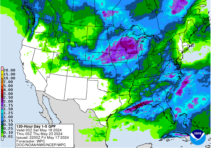
Northeast Unsettledness
The Northeast is a complicated story: a cut-off low sitting off the coast of New England will keep temperatures cooler and cloud coverage higher the next few days. As the system remains in place, higher amounts of precipitation are expected and the potential for severe thunderstorms exists across PA today as a shortwave trough swings through. This trough will help move the cut-off low eastward and away from the northeast allowing for a pleasant weekend, but a frontal passage will bring unsettled weather once again next week.


