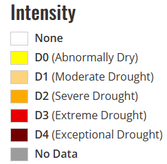
Seasonal temperatures and isolated to scattered showers and thunderstorms will be persistent across central and eastern portions of the state for the remainder of the week before we may see the heat begin to stick around more frequently by next week and beyond. Overall synoptic pattern aloft remains the same as it has been for the majority of the summer up to this point, with upper-level high pressure sitting in the western US and low pressure off in the northeast US and southeast Canada.
This has left us with northwesterly flow aloft and given us near daily chances for precipitation and average temperatures across the state and will generally remain that way over the next week or so. Beyond this week, the region of high pressure off in the west will begin to spread its influence eastward across the central US and may begin to heat us up and dry us out.
[wpcode id=”41149″]
Short-Term Outlook
Today will be the hottest day for many, with temperatures ranging from the upper 90s to low 100s across central and eastern Kansas, although the exception to this being those on the northern side of this surface trough and associated stationary front across central and eastern Kansas. Those that do remain on the north side of this trough will see cooler temperatures ranging from the mid 80s to low 90s.
Placement on this trough will vary but the areas with the best shot at seeing these higher temperatures look to be south of I-70. Precipitation chances will be low and isolated, with the best overall chances being in far northeast Kansas (3am to 11am) from the passing of showers and thunderstorms from eastern Nebraska. This will also contribute to the aforementioned cooler temperatures as compared to the rest of the state. If these storms are able to become severe, damaging winds will be the primary concern.
Tomorrow will see temperatures cool down in wake of the departing surface low from today, with temperatures ranging between the upper 80s to low 90s across the board. Another cold front coming in from the north will punch its way through tomorrow evening and overnight and help solidify our run of seasonal temperatures across the state.
Scattered showers and thunderstorms may be possible with the arrival of this front in the evening and overnight hours (7pm to 12am), with the best chance at any of these storms becoming severe existing in far north-central Kansas closer to the Nebraska border.
Thursday looks to be more of the same as Wednesday. Temperatures across the state will continue to be in the upper 80s to low 90s and rain chances will be quite low and isolated, with the best opportunity at substantial rain being in central Kansas along I-135 and west during the evening and overnight hours. These showers may persist and spread more eastward by midnight and early Friday morning before departing by early Friday afternoon.
[wpcode id=”41149″]
Long-Term Outlook
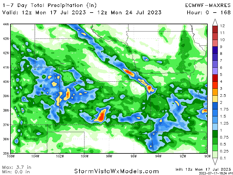
Average temperatures between the mid 80s to low 90s and scattered rain chances will persist all the way through early next week under continued northwesterly flow aloft. Rain totals over the next 7 days look to largely remain at or below an inch, although higher amounts are possible with any stronger thunderstorms.
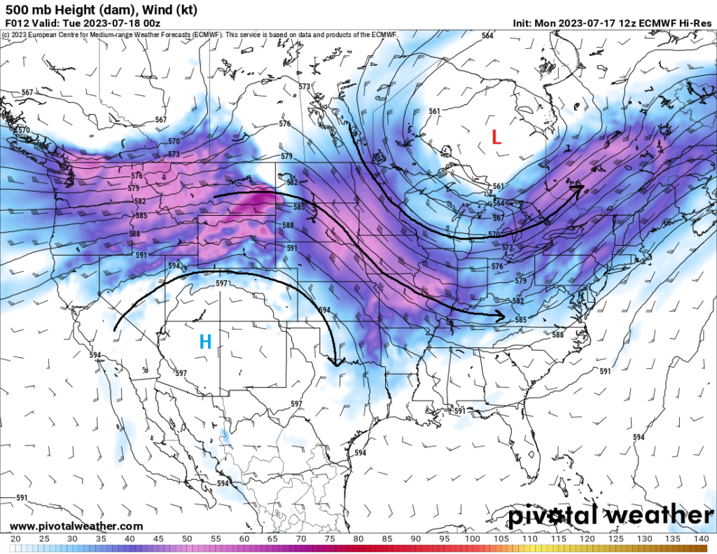
By Tuesday of next week, the northwesterly flow will be displaced and shifted north, followed by high pressure overspreading the Central Plains and beginning to raise daytime temperatures to at least the mid 90s. Rain chances can be expected to taper off as well as this high-pressure system will start to suppress storm development more and keep us drier.
[wpcode id=”41149″]
Agriculture Forecast
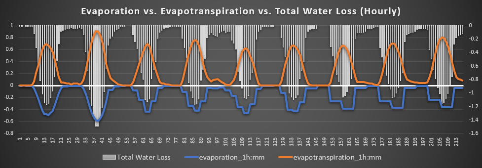
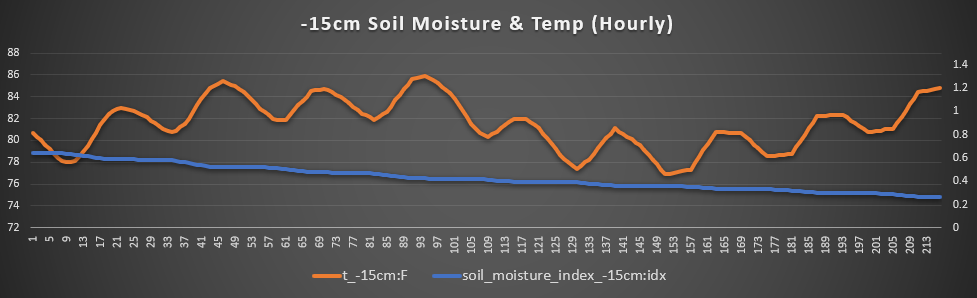
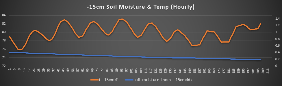
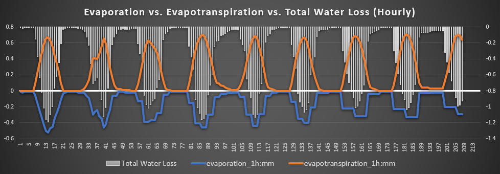
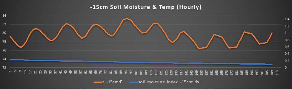
McPherson, Hutchinson, and Sterling – Out here in Central Kansas, we will continue to see an overall trend of drying out throughout the week, with the only real substantial chance at rainfall over the next 7 days being Thursday afternoon to Friday morning (3pm to 5am). Temperatures look to hover around the mid 80s to lower 90s, with the exception of today, where temperatures may reach up to 100 degrees. Winds will remain largely around 5 to 10 mph out of the east and north.
Total water loss will be worst today, at around 1.5mm per hour, before hovering around 1 to 1.2mm per hour for the remainder of the week. Highest average soil temperatures will remain between 84°F-86°F over the next couple days before falling down to between 80°F-82°F by days 3-6.
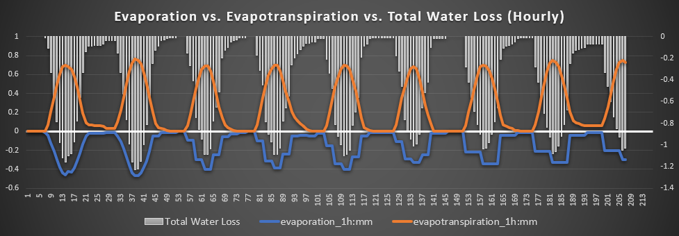
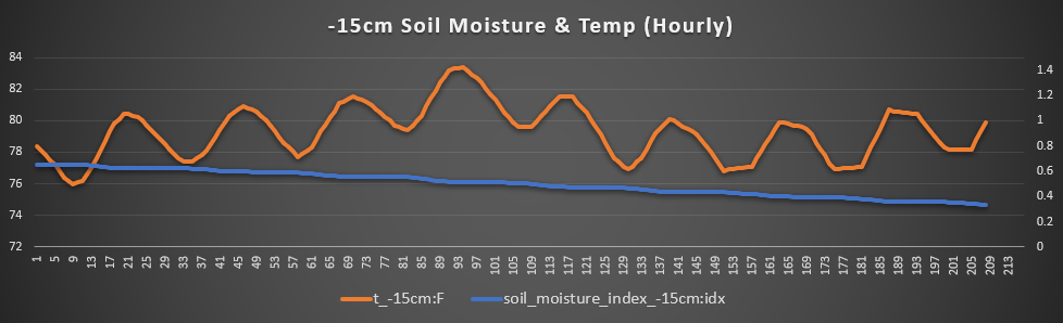
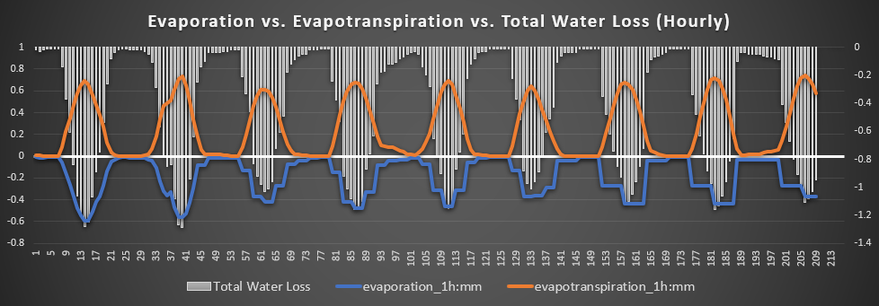
Minneapolis, Concordia, and Beloit – Like down further south, here in north-central Kansas, substantial rainfall chances will be scant. Temperatures will range between the upper 80s and low 90s for the remainder of the week and into early next week.
Winds will be around 5 to 10 mph out of the east. Total water loss will remain fairly consistent at around 1 to 1.2 mm per hour and soil temperatures ranging between 80°F-83°F over the next 7 days.
Lawrence, Ottawa, and Olathe – Rain chances here in eastern Kansas look to be the least out of anywhere else in the state. The best opportunity will be, outside of hit and miss isolated thunderstorms, the group of thunderstorms moving through northeast Kansas this morning. (6am to 10am).
Temperatures otherwise throughout the week will range between the upper 80s to low 90s over the next week, with today the exception being in the upper 90s. Winds will vary between 5 to 15 mph predominantly out of the north. Total water loss will stay largely consistent throughout the week at 1 to 1.2mm per hour and soil temperatures staying around 80°F-83°F.
Burlingame, Osage City, and Lyndon – Dry soil conditions will largely persist across the area over the next week. Isolated showers and thunderstorms will be possible over the next 7 days, but the overall chance is low. Air temperatures will be highest today in the upper 90s before we cool down a bit into the upper 80s to low 90s over the course of this week.
Sustained winds will range between 5 to 15 mph mostly out of the north. Total water loss here will also range between 1 to 1.2 mm per hour and soil temperatures hovering between 80°F-83°F.
[wpcode id=”41149″]
Climate Update
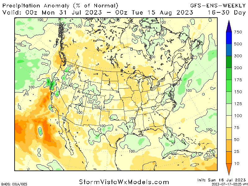
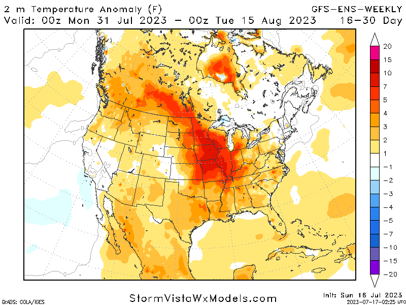
Long-range guidance suggests high pressure persisting over the state through the end of the month and into early August. Rainfall under this regime would begin to lessen, with much of the state projected to see only 50-75% of normal rainfall over this period of time. This would also allow air temperatures to heat up progressively across central and eastern Kansas, adding to the drying out of soil conditions across the state.
[wpcode id=”41149″]
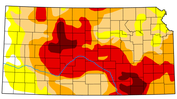
Drought Update
Drought conditions remain largely unchanged from last week across central and eastern Kansas, with the majority of the area under drought conditions and the worst being in the counties of Elk, Chautauqua, Butler, and Cowley. Drought relief will be less and less though, as high pressure will start to build in by next week and limit rainfall. Rainfall in the short-term will be concentrated greatest towards central Kansas before substantial rainfall looks to become more elusive.