Good afternoon, Pinebelt!
If you haven’t heard already, the National Hurricane Center has put out a track for Barry showing a range of landfall between the mouth of the Mississippi River in east Louisiana to near the Louisiana-Texas border. Models are still divided on this in the long run. Depending on how strong the ridge is in the southwestern US, Barry could turn slightly west, however if the ridge strengthens before landfall, we’ll see it move towards us and more rain and wind will be in the picture.
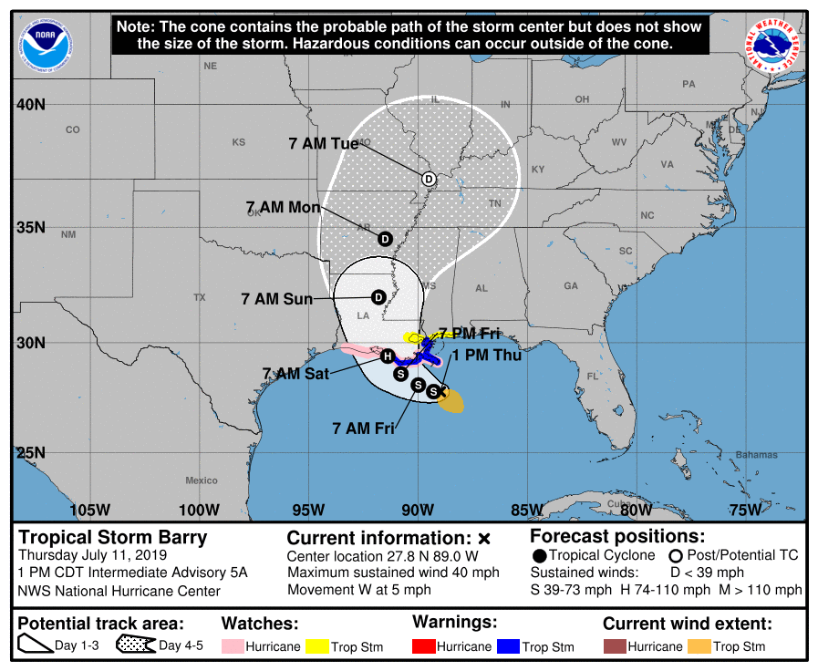
So far, Tropical Storm Barry hasn’t been able to get its full act together because of a ridge out in the Atlantic pushing dry air into it’s northeastern quadrant. While it is rotating around an axis, it’s southern and western side is the strongest as noted by the satellite image. As Barry has more time to gather moisture from the Gulf before it makes it to land, the forecast models show the northeastern quadrant becoming more organized which means that Barry will be in much greater form.

Depending on where the landfall is, we will probably see a minimum of a few inches of rain if it goes further west, but if it comes further east, it means much heavier amounts for us. The estimated time of arrival for the Pinebelt will be sometime Friday night and Barry won’t be leaving until Monday since it’s a slow moving storm. Saturday we’ll see plenty of rain and a few thunderstorms and the rain won’t be letting up.
Friday will be mostly cloudy throughout the day as we wait on a band of rain to come in later in the afternoon. High of 88, low of 76 and winds E at 5-10 mph.
Saturday is when the relentless rain starts and the winds start to pick up. High of 80, low of 75 and winds SE at 10-20 mph. Rainfall amounts 1-2 inches.
Now over to Amber for the rest of your weekend and week ahead.
Sunday will be a wet day around south Mississippi expect rain off and on for most of the day as Barry moves past the area. If you go out on Sunday have your lights and windshield wipers on and pay attention to road conditions as there may be some flooded roads. If you come to a road that is flooded turn around don’t drown. Starting off next week we are still dealing with the left overs from Barry. Rain chances go down as we move through the later part of the week but after the tropics cool down we warm back up.
Sunday – Rain will be the main story for Sunday which will keep the temperatures down a little from normal. The rain chance for the day will be 80 percent with a high temperature around 77 degrees thanks to overcast skies and rain. Overnight we stay in the 70’s with a low temperature around 71 degrees.
Monday – Barry sticks around for another day giving us a 40 percent chance of rain for the day. The temperatures will be a little warmer than yesterday with a high around 84 degrees it will stay overcast so that will help in keeping the temperatures down once again. Overnight we will drop into the mid 70’s around 72 degrees.
Tuesday – Rain chances go down just a bit as whats left of Barry moves away. As we start to get back to normal summertime around south Mississippi that can only mean one thing it will be warming back up. High temperatures for Tuesday will be around 87 degrees so still not to bad for July with a 30 percent chance of rain around the area. Overnight Tuesday we drop back into the 70’s with a low around 73 degrees.
Wednesday – Gets a little warmer with a high temperature near 89 degrees we will still have some clouds around the area that will help keep us a little cooler. Rain chances will stay around 30 percent. The overnight hours stay warm with the low temperature only dropping to around 74 degrees.
Thursday – We reach the lovely 90 degree mark once again in south Mississippi so any outdoor plans you have make sure to have plenty of water handy also make sure to take breaks and get somewhere cool. Rain chances will be lower at 20 percent for the day so the chance of a shower finding you is low. As we moving into the overnight hours temperatures stay in the mid to upper 70’s around the area.
The take away from this forecast is if you do have plans this weekend stay weather aware. No I am not saying we will have severe weather I’m just saying it is going to rain and that means we could experience some flooding so just have a plan in place if you happen to get caught in flood waters. After this weekend things will be back to the normal heat here in south Mississippi.


