12/28/17 1:00PM UPDATE: There is a new forecast available here: Models trending drier for New Year’s Eve in South Mississippi
The morning model data has been wrestled with, and before the afternoon data starts to roll in, I wanted to offer a brief look at what the morning data shows and what the forecast is looking like right now. I charted out the chances for different types of precipitation for New Years Eve as well as the forecast temperature, given the current available data.
And while this forecast is likely to change – perhaps a lot, since we are still about 4 days out – here is the current thinking.
Reading this graph
– Temperature = Red
– Rain = Green
– Yellow = Sleet
– Purple = Freezing Rain
– Blue = Snow
– The numbers on the left are for temperature
– The numbers on the right are for the percent chance as a decimal (so a reading of 0.25 = 25% chance)
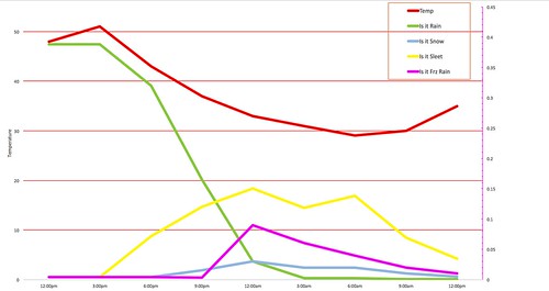
Notice that the overall chance for precipitation as rain starts out around 40% and falls to about 5% by midnight.
The chance you see sleet start to increase above 10% by 9pm, but never get above 20%
Freezing rain? Never really higher than 10%, except shortly after midnight
And the chance for snow is under 5% the whole time.
The temperature approaches freezing around midnight, December 31, and may stay below freezing through noon on January 1.
The Take Home
This is going to be another tricky forecast in the coming days as we wrestle with how cold it is going to be, and when, and at what levels in the atmosphere is the temperatures going to be above or below freezing. And then figuring out if that layer of the atmosphere saturated with water or not.
There are going to be a lot of moving pieces, and by the time we get to Sunday night, the forecast for Laurel may be different than the forecast for Purvis and that might be different than the forecast for Magee.
And as of now, I don’t want to estimate precipitation totals, as those will change wildly every new model run. As of now, estimating precipitation totals is simply an exercise in futility.
But we’ll do our best to stay on top of it for you!
And remember, if you want more information on making snowflakes you can find it here! Or for tips on winterizing your home and making an emergency kit, you can find that here!


