Well, it wouldn’t be Winter in south Mississippi without crazy temperature swings and severe weather, right? Looking ahead to the end of next week, we may have to wrestle with some storms and the threat for some severe weather, too.
The Temps
As we transition out of this cold air, we are going to actually do a good job at getting back to above-average conditions. Temperatures late next week could be in the 70s by Thursday and Friday. And while specific timing for when the next cold front arrives is still a bit grey, the idea is that by Saturday we will be on the backside of it and into more chilly weather again (but not crazy cold).
The rebound to above average temperatures after a cold snap like this isn’t a weird thing.
I’ve heard from some people who can’t believe that we would be going from one extreme to another. This happened last January, too. Though, admittedly, not as drastic of a swing. After a day or two of lows in the teens and 20s, we spent a few days flirting with the mid 70s. And back in 2015 we did about the same thing, too.
Neither of the previous cases were quite as drastic a change in temperatures – a handful of days in the 30s and 40s then a handful of days pushing 70 – but the thought that this is strange doesn’t carry as much weight when you look at the record books.
The Storms
The real question is just how much moisture will be available and where is that moisture coming form. Run-to-run consistency hasn’t been great but it is starting to trend in a certain direction.
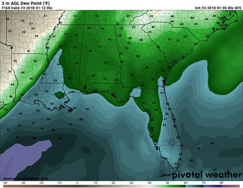
The dewpoints – a measure of how much moisture is in the air – will be back into the 60s by next Thursday. That is a far cry from the single-digits we are feeling right now in south Mississippi. As the dewpoints rebound, a trough and cold front will swing in from the northwest. There is still some question as to just how fast it will be moving and how cold it will be.
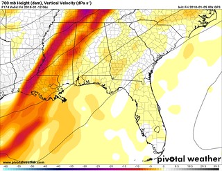
The colder and faster? Better chance for a line of strong storms to move through with heavy rain, lightning, gusty wind and some hail. The tornado threat may be held in check by the faster front not allowing higher dewpoints (more atmospheric moisture) to pool ahead of the front.
The warmer and slower? Probably a broken line storms would be more likely. Heavy rain, lightning, gusty wind still in the mix. The tornado threat – depending on some other factors – may be a bit higher in this case (just this time, this isn’t a Rule of Thumb) as higher dewpoints could hang around for longer. Plus the slower movement would leave our area in the right place in relation to the trough to promote better wind shear within the atmosphere.
Somewhere in between? Likely where we will be. When looking out this far using the operational models, they don’t do a great job figuring out specifics. That is why we tend to look at Ensemble Models this far out. Ensembles blend together multiple different possible outcomes to give a best average guess based on the possible outcomes.
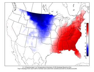
The CIPS Analogs looks at that and compares it to the past, showing that severe weather is possible.
Based on the CIPS Analogs there is a lower chance that we deal with severe weather, but not a zero chance.

Severe weather may not be the whole story, though. The ECMWF computer weather model is showing something that quite a few of the Ensemble members of the GFS computer weather model also show: A lot of rain.
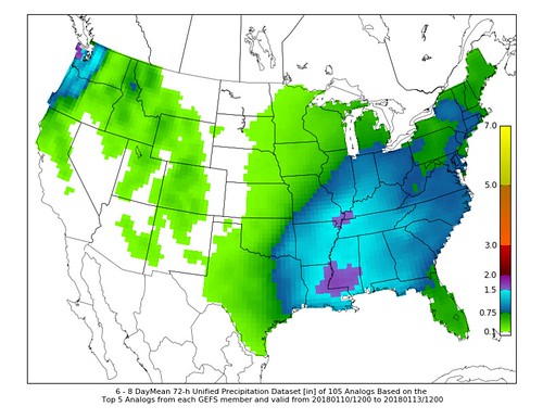
CIPS is showing 1.5″ to 2″ of rain possible across the area. This is much needed give that parts of the area are back in different levels of drought. That said, getting it all at one time may not be ideal. Given how dry the ground is, we may see considerable runoff instead of the water simply soaking into the ground. That may lead to localized – but not catastrophic – flooding.
Bottom Line
Still too early for specifics on late next week. But please keep an eye on the forecast. We may be dealing with storms. And some of those storms may be severe. And depending on how things shake out, we may also have to deal with some localized flooding.


