A cold front is approaching today, but don’t get too excited for rain. This looks to be mostly dry as it passes through, with only about 1/4″ to 1/2″ or rain by the time things are all said and done. And it may take 36 hours to get to that point.
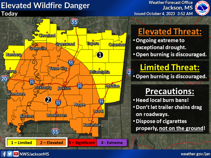
There’s a slight chance of light rain in the western areas today, but overall, temperatures will remain unseasonably warm. Despite an increase in moisture from the west, this won’t lead to significant rain nor cooling. As a result, temperatures will rise into the upper 80s to lower 90s, particularly in areas already grappling with extreme drought. This elevated heat, combined with low humidity, raises the risk of wildfires, especially in those drought-stricken regions.
On Thursday, as the shot for a few storms increases, there could be a wind shift ahead of the actual front due to a prefrontal trough. However, the actual cold front, along with a significant change in air mass, won’t reach our area until Friday. At that time, another chance for scattered showers and a few thunderstorms are possible along and ahead of the main front.
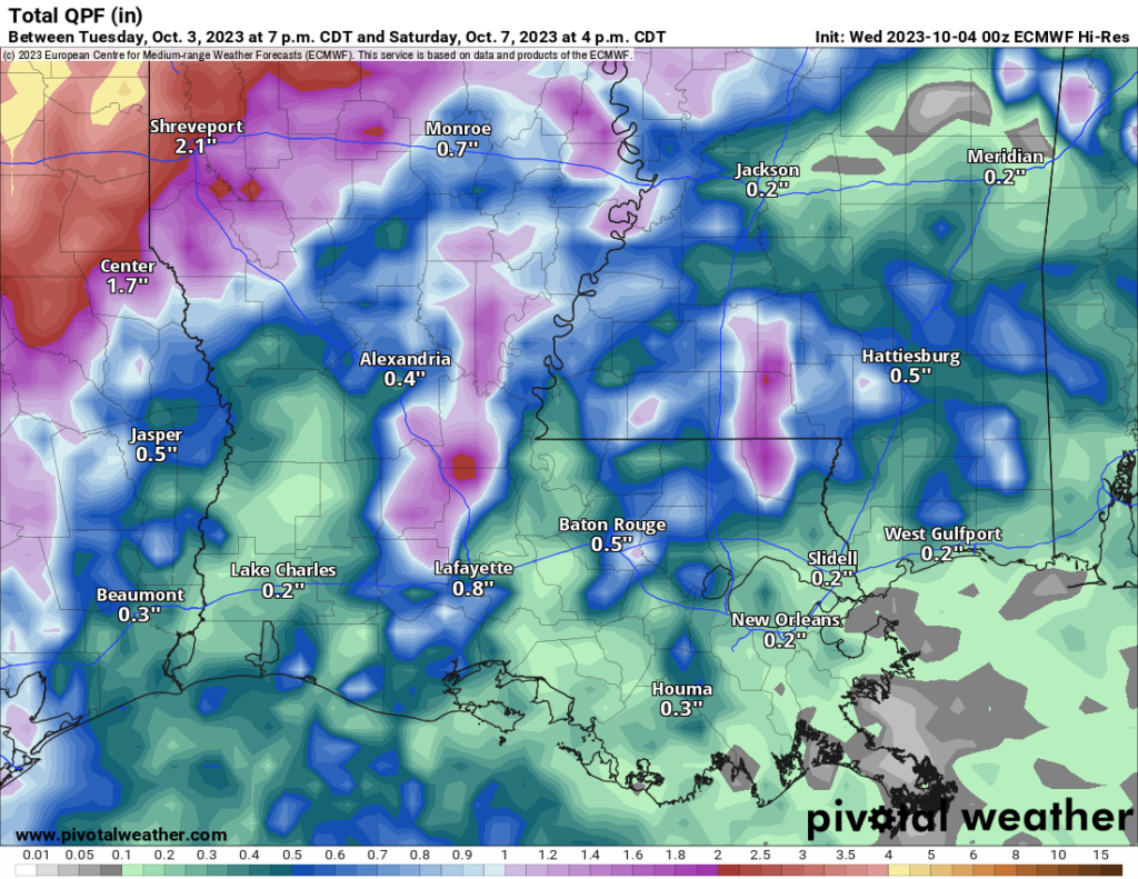
Unfortunately, rainfall totals are expected to be relatively low, with most areas receiving less than a quarter of an inch. Friday night will see a significant cooling trend, with temperatures dropping into the 50s for most locations.
In the wake of the front, we’ll experience the coolest air mass since early May, with common low temperatures in the 40s and 50s on Sunday and Monday mornings. Dry conditions will persist into the beginning of next week. Some model guidance suggests that dewpoints might drop significantly on Saturday – even though that isn’t in the official forecast yet, it’s worth noting. Because when you couple that with pre-existing drought conditions and breezier conditions that would heighten the risk of wildfires across most of the area.
[wpcode id=”41149″]
REGIONAL DAY TO DAY FORECAST
Today: Sunny. Highs in the lower 90s. East winds 5 to 10 mph.
Tonight: Mostly clear in the evening, then becoming partly cloudy. Lows in the mid 60s. Southeast winds around 5 mph, becoming east after midnight.
Thursday: Partly sunny. Highs in the upper 80s. East winds 5 to 10 mph, becoming southeast in the afternoon.
Thursday Night: Mostly cloudy. Lows in the upper 60s.
Friday: Partly sunny. A slight chance of showers in the afternoon. Highs in the upper 80s. Chance of rain 20 percent.
Friday Night: Mostly cloudy. A slight chance of showers in the evening. Lows in the lower 60s. Chance of rain 20 percent.
Saturday: Mostly sunny. Highs in the upper 70s.
Saturday Night: Partly cloudy. Lows in the lower 50s.
Sunday: Mostly sunny. Highs in the mid 70s.
Sunday Night: Mostly clear. Lows in the upper 40s.
Columbus Day/Indigenous Peoples’ Day: Sunny. Highs in the upper 70s.


