← Back Skip to content

NickelBlock Forecasting

We've got you covered

  • Severe Weather Outlook
    • SPC Discussion & Graphics
    • Severe Weather by Threat
      • Today’s Severe Weather Threat
      • Today’s Tornado Threat
      • Today’s Severe Wind Threat
      • Today’s Severe Hail Threat
    • National Convective Outlook
    • Severe Outlooks By State
    • Excessive Rainfall Forecasts
  • Forecast Discussions
    • Tropics
    • Short-Term
      • Short-Term Forecast
      • National Convective Outlook
      • Severe Outlooks By State
      • National Precipitation Chances
      • National Precipitation Estimates
      • National Snowfall Estimates
      • National Ice Estimates
      • Excessive Rainfall Forecasts
    • Medium-Range
      • Medium-Range Discussion
      • 10 Day Trend
    • Seasonal Outlook
      • Monthly/Seasonal Discussion
  • Wx Extras
    • Southern MS/AL/LA Ag Forecast
    • Comprehensive Ballpark Forecast
    • River Forecast Page
    • Interactive Radar & Satellite Loop
    • Weather Safety
    • Hurricane Preparedness Tips
    • Corvallis & OSU Forecast
  • Our Organization
    • About us
    • Our Services
    • Contact Us!
    • Meet the Team
    • Testimonials
    • Jobs
    • Privacy Policy

Dora Continues to Explore the Pacific. Atlantic Remains Quiet.

Author: Bruce Pollock || Published: 8/10/2023 at 11:10pm

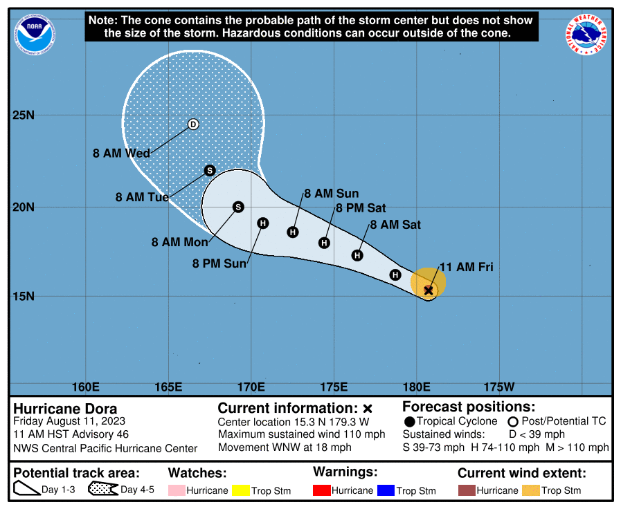
Hurricane Dora continues to traverse the Pacific Ocean and is expected to leave the Central Pacific Basin for the West Pacific. As Hurricane Dora makes this journey, it is expected to finally begin to weaken from a major hurricane as harsh shear and dry air work its way into the core of the storm. The cyclone will also gain the designation of Typhoon once it enters the Western Pacific Basin which for a storm with origins in the Eastern Pacific is a rare title for it to earn. Elsewhere, we are monitoring three areas of interest in the Central and Eastern Pacific Basins for development while the Atlantic remains hostile to new development for the time being.

Infrared Satellite Image of Major Hurricane Dora // Courtesy of Tropical Tidbits


Short Term Outlook

Hurricane Dora as mentioned should remain a major hurricane for the next few days as it moves from the Central Pacific to Western Pacific basins. Hurricane Dora has been able to persist despite suboptimal conditions due to the annular nature of the cyclone which works to sustain itself as well as negate the effects of dry air and wind shear. Other then some heightened surf, Dora won’t bring any direct impacts to nearby landmasses and should begin to recurve and dissipate once in the Western Pacific Basin.

Best Track for Major Hurricane Dora //Courtesy of Central Pacific Hurricane Center

Looking elsewhere in the Pacific we are currently monitoring three areas for development. One spot, is a region in the Western potion of the Eastern Pacific basin. A disorganized area of showers and thunderstorms associated with a tropical wave may slowly begin to organize as it moves westward at 10-15mph, but development within the next few days remains unlikely at this time. Another location is in Eastern Pacific Basin associated with another tropical wave looks to have more favorable conditions for tropical development as showers and thunderstorms are forms in a region which has lower wind shear and higher SSTs. This wave should move generally westward and begin to take shape over the coming days. Finally, closer to the Mexican Coastline an area of low pressure is expected to form and conditions appear favorable for this low pressure region to generate a tropical cyclone that will travel parallel to the Western Mexican coastline.

Eastern Pacific Basin Outlook // Courtesy of NHC

Looking into the Atlantic briefly, development does not look likely in the short term. The basin overall is hostile to any development due to dry air and high wind shear. Furthermore, this trend doesn’t appear to be changing much throughout the next seven days.

Atlantic Basin Tropical Outlook // Courtesy of NHC


Extended Outlook

Looking into the long term the Pacific Basin looks to continue its active stretch while the Atlantic remains quiet. Both basins have warm SSTs, but the hostile wind shear in the Atlantic will keep any tropical development at bay for now. As we approach peak season, conditions could change and the Atlantic could wake up, but for now those along the Atlantic coastline can enjoy the quiet tropical season while also preparing in case of future impacts as it only takes one storm to make a season.

MSLP Ensemble Members // Courtesy of Tropical Tidbits


Conclusion

In conclusion, Hurricane Dora continues to trek across the Pacific as a Major Hurricane. We are monitoring three areas of interest in the Eastern and Central Pacific Basins for tropical development, but any new development should hold off for at least the next few days. The Atlantic basin remains quiet, and is expected to remain that way for the next week, but as always a reminder to remain vigilant and keep everything up to date to ensure that if a storm forms and moves your way you are prepared for what may come.

Filed: Archive, Forecasting, Tropics || Covering: 2023 Atlantic Hurricane Season, 2023 Pacific Hurricane Season, Atlantic Basin, Central Pacific Basin, Eastern Pacific Basin, Hawaii, Hurricane Dora, International Dateline, Invests, Tropical waves, tropics, Typhoon, Western Pacific Basin


Author of the article:


Bruce Pollock

Bruce is a recent graduate of the University of Oklahoma with a degree in Meteorology. Bruce is continuing his education at the University of Albany this fall in the Emergency Management & Homeland Security departments to learn more about communicating risks in the weather enterprise.

Post navigation

Previous post Today’s Ballpark Forecast- 8/10/23
Next post Heat Dome Taking Over This Weekend With Scattered Storms About: Southern MS/AL/LA Weather Forecast – 8/11/23

Dig Through the Archives


Search the Site


Today's Severe Risk

SVR WX THREAT

Today's Tornado Risk

SVR WX THREAT

Topics We Cover

2019 Atlantic Hurricane Season 2020 Atlantic hurricane Season Alabama Weather Amarillo weather Archives cold cold front CONUS Weather Coronavirus COVID-19 COVID19 Drought Flooding Forecasting freezing rain Gulf Coast Weather hail Heat Hurricane hurricanes Kansas Agriculture Kansas Weather Louisiana Weather Mississippi Weather NHC pine belt weather rain Severe Thunderstorms Severe Weather snow Southeast weather south Mississippi weather SPC Texas Weather Thunderstorms Tornadoes Tropical Storm Tropical Weather tropics weather weather forecasting weekend forecast weekly outlook Wind Winter Weather

Wx Coverage


  • Archive
  • Climate
  • Education
  • Environment
  • Forecasting
  • Geology
  • High Plains Weather
  • Midwest Weather
  • Northeast Weather
  • Northwest Weather
  • Not Weather
  • Research
  • River Flooding
  • Seasonal Outlooks
  • Severe Weather Discussions
  • Site Updates
  • South Plains Weather
  • Southeast Weather
    • Coastal MS/AL/LA
    • Southeast Mississippi / Southwest Alabama
    • Southwest Mississippi
  • Space
  • Storm Chasing
  • Tropics
  • Weather & Sports
  • Weather & TV
  • Weather History
  • West Coast Weather
  • Research


    The Future of Erie Lake Effect Snow: A Linear Analysis
    July 20, 2025

    Review: 2023 Rolling Fork–Silver City tornado
    July 14, 2025

    Research – MS/AL/LA’s unique climate history; how sulfates may have played a part in keeping our area cool for the past century
    July 13, 2025

    Forecasting with a Partial Deck in Mother Nature’s Casino
    March 24, 2025

    Research: How does diurnal temperature range affect human health?
    August 2, 2024

    Archives


  • March 2026
  • February 2026
  • January 2026
  • December 2025
  • November 2025
  • October 2025
  • September 2025
  • August 2025
  • July 2025
  • June 2025
  • May 2025
  • April 2025
  • March 2025
  • February 2025
  • January 2025
    • Home
    • Archive
    • Search the Site
    • Model Data Viewer
    • Login
    © Copyright NickelBlock Forecasting. All rights reserved.