Hey everyone! We’re bringing back our CONUS weather forecasts, starting with this update. In these posts, I’ll break down the overall weather pattern across the country, highlight the main regions seeing impactful weather, and provide a regional look at temperature and precipitation trends for the week ahead. Let’s get started!
Today’s Overall Setup

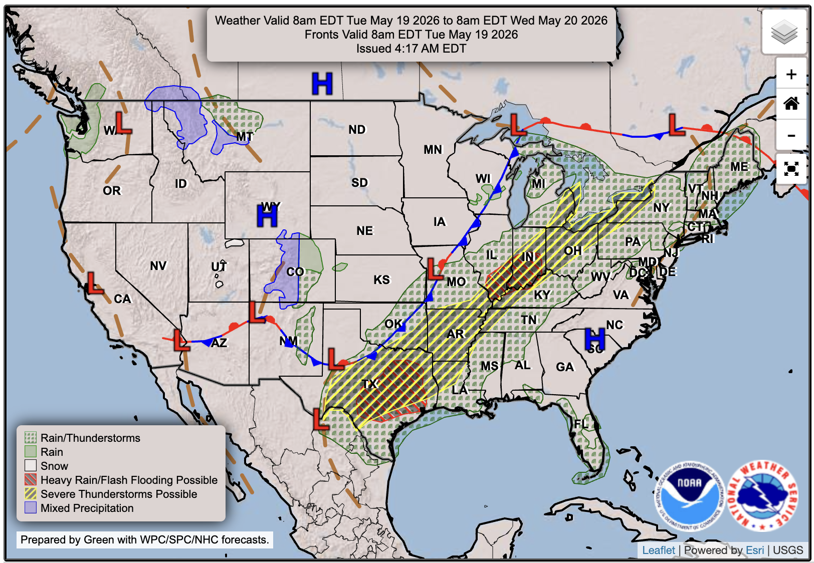
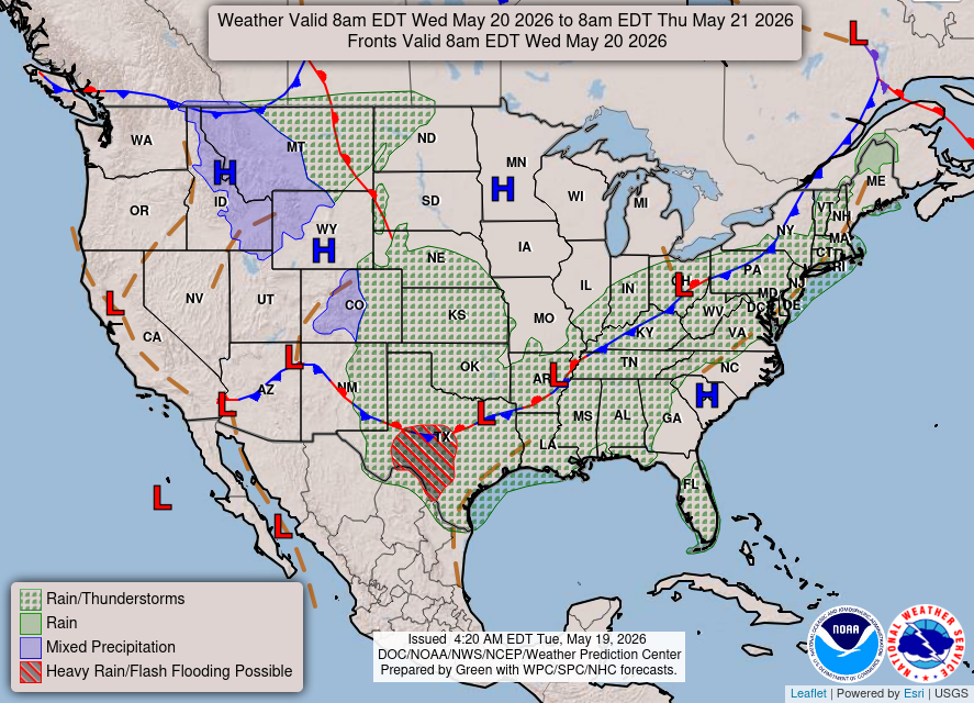
We’re starting off with a pretty active pattern across the central and eastern U.S. today. A frontal boundary stretching from Texas up into the Great Lakes and Northeast will be the main focus for showers and thunderstorms through the day.
The highest-impact weather looks to be from the Southern Plains into the Mississippi and Ohio Valleys, where heavier rain and some stronger to severe storms will be possible. Farther east, rain and storms will also spread into parts of the Great Lakes and Northeast, while the Southeast stays warmer and a bit quieter under higher pressure.
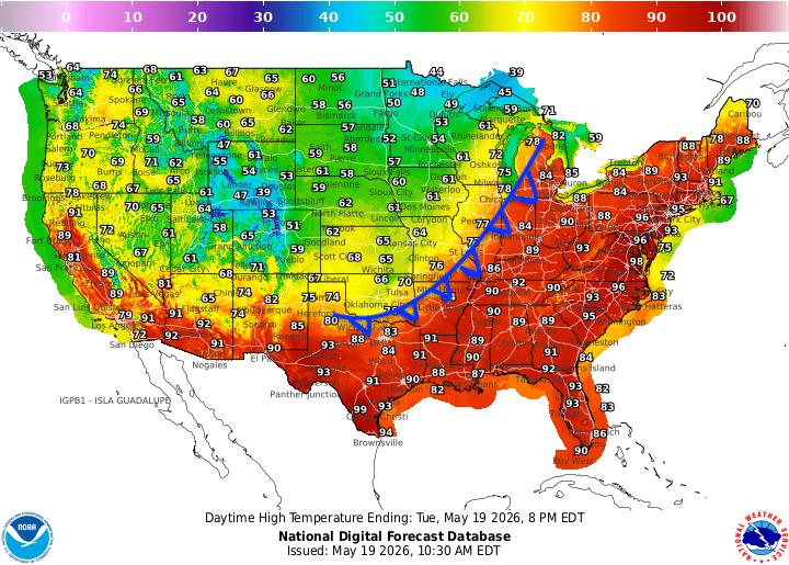
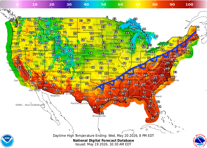
The heat is definitely one of the bigger stories today, especially across the eastern U.S. Under a broad southwesterly flow around a high pressure system over the western Atlantic, warm and humid air is being pulled northward ahead of the front, allowing temperatures to surge well above normal for many areas.
Highs will climb into the upper 80s and lower 90s from Texas and the Gulf Coast into the Southeast, Ohio Valley, and Mid-Atlantic. Some spots in the Carolinas, Georgia, and the interior Northeast may even make a run at the mid to upper 90s. Will some areas in the Mid-Atlantic reach 100? I think its definetly possible. Plus heat indicies will be certainly reaching 100+ in many areas today. Definetly a day to stay hydrated and in the air conditioning if possible! Farther north and west, temperatures drop off pretty quickly behind the cold front, with much cooler air across the northern Plains and Rockies. Just look at that contrast!
Today’s Severe Weather Threat
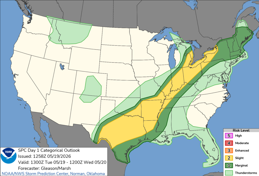
As mentioned earlier, severe weather is one of the main things we’ll be watching today. There is a pretty large Slight (Level 2 out of 5) risk zone running from Texas and the Southern Plains up through the Mid-South, Ohio Valley, lower Great Lakes, and into parts of the interior Northeast.
The main issue looks to be damaging wind gusts, especially if storms can organize into clusters or bowing line segments along the front. Hail is also on the table, with the better chance for larger hail focused back across west-central Texas, where a few stronger storms could develop along a dry line. The tornado threat is not the main concern today, but a brief spin-up can’t be ruled out.
Overall, today does not look like a major severe weather outbreak, but there is enough moisture, instability, and lift along the front for scattered strong to severe storms through the afternoon and evening.
Tomorrow’s Weather
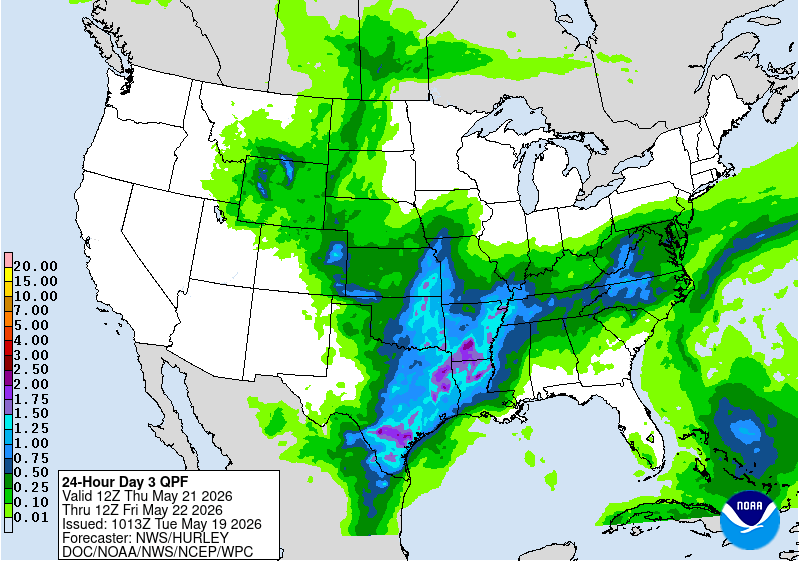
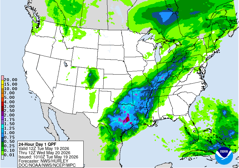
Tomorrow, the same general boundary will still be hanging around, but it will have moved south and east. Showers and thunderstorms look likely from parts of the Plains into the Mississippi Valley, Tennessee Valley, Southeast, Mid-Atlantic, and Northeast. The heaviest rain potential appears focused across parts of Texas, Oklahoma, Arkansas, and Louisiana, where some localized flooding issues could develop.
The heat will still be a big story too, especially along the East Coast. Highs will climb well into the 80s and 90s from the Southeast into the Mid-Atlantic and parts of the Northeast, with some spots pushing the mid to upper 90s. Behind the front, cooler air will settle into the Great Lakes and northern Plains, where highs will be much more comfortable in the 50s, 60s, and lower 70s.
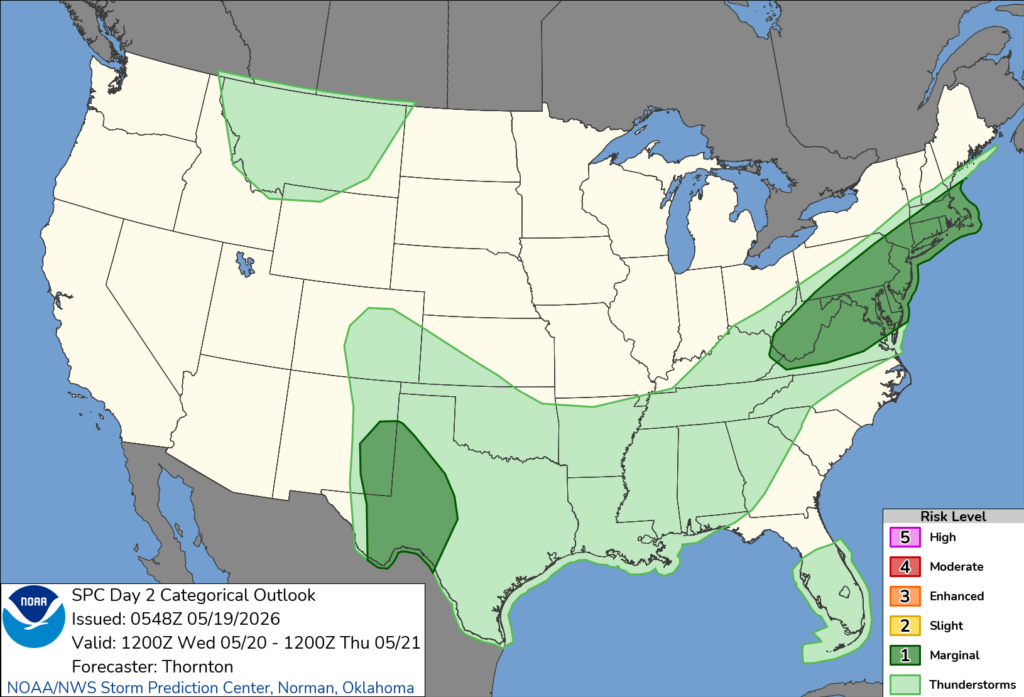
Severe weather looks more limited compared to today, but a few stronger storms are still possible, mainly across the southern Plains and parts of the Mid-Atlantic/Northeast. Damaging wind gusts and hail would be the main things to watch, as the tornado threat is less than 2% in all areas.
CONUS Weekly Temperature & Precipitation Outlook
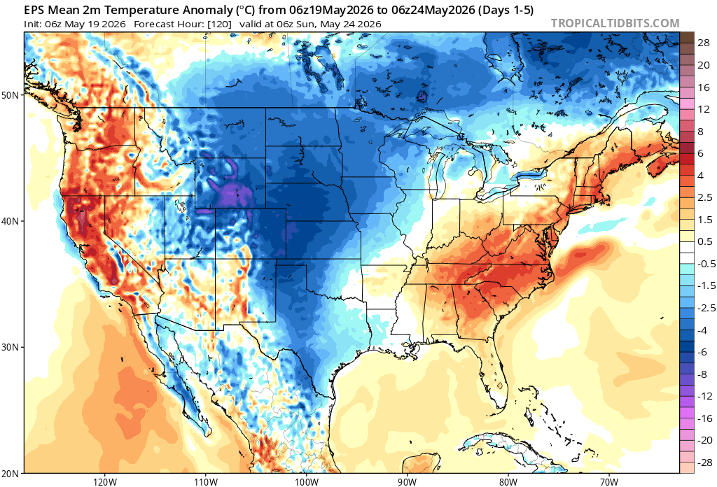
Here’s a look at the EPS modeled temperature anomalies through Sunday. Red indicates above-average temperatures on average for the week, white indicates average temperatures, and blue indicates below-average temperatures.
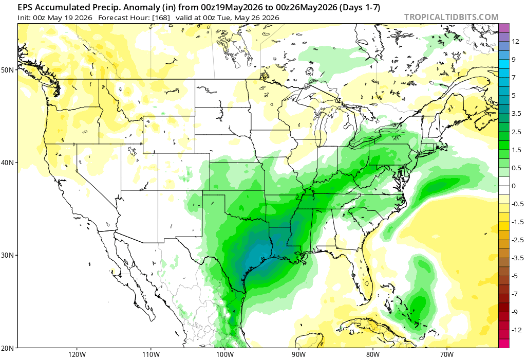
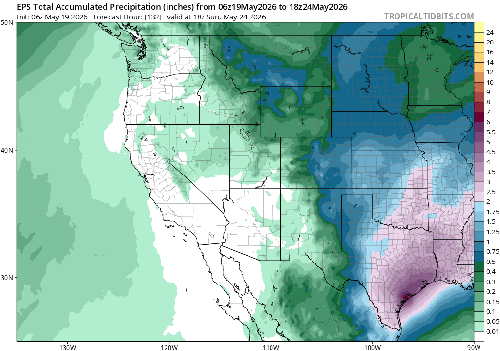
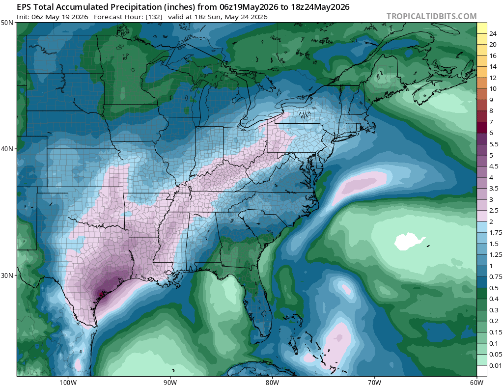
Here’s a look at the EPS modeled precipitation anomalies through next Tuesday. Green indicates above-average precipitation, white indicates average precipitation, and yellow indicates below-average precipitation. Let’s look into the details by region:
Weekly Outlook: Western & Central United States
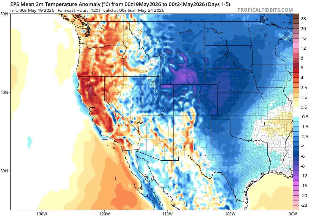
For the western and central U.S., the week as a whole has a pretty clear split. The immediate West Coast stays warmer than average thanks to ridging/high pressure just offshore, which keeps warmer air in place from California into parts of the Pacific Northwest. That same setup also keeps much of the West fairly dry, so widespread rain is not expected there.
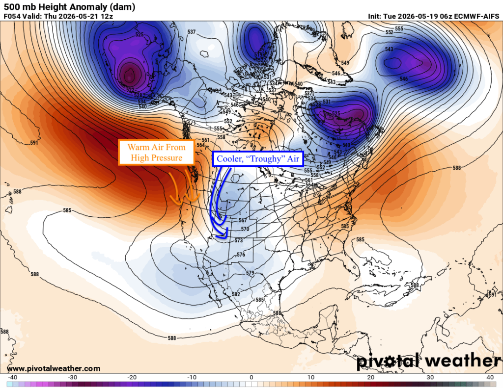
Farther inland, it’s a different story. A trough dipping into the Intermountain West and central U.S. will keep temperatures below average from the Rockies into the Plains as a whole this week. It also keeps precipitation chances more active through the central U.S., especially from the High Plains into Texas and Oklahoma.
Weekly Outlook: Eastern United States
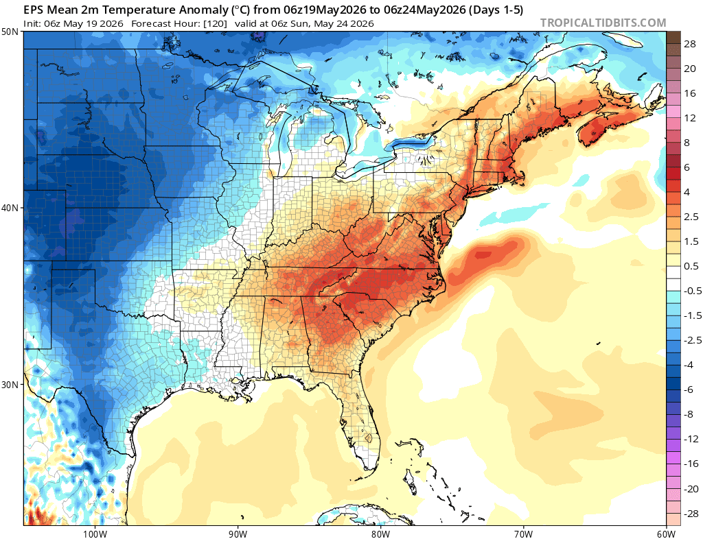
For the East, the week starts off very warm to downright hot, with some record-breaking heat possible before the front moves through. With troughing farther west and ridging near the East Coast, southwesterly flow will pull a surge of warm and humid air northward from the Southeast into the Mid-Atlantic, Northeast, and New England.
The front will also bring rain and storm chances as it works east, especially from the Mid-South and Ohio Valley into the Appalachians, Mid-Atlantic, and Northeast. Once it clears, temperatures should cool back down behind it, so the hottest conditions are more of an early-week story rather than something that lasts all week.
Travel Outlook
For anyone traveling today, just keep an eye on the storms along that broad severe weather corridor. Some of the main interstates that run through the main severe weather threat include I-35, I-40, I-44, I-55, I-65, I-70, I-71, I-75, I-76, I-80, I-81, I-86, I-87, and I-90.
Not everyone along these routes will see severe weather, but storms that do develop could bring heavy rain, gusty winds, and quick reductions in visibility. Just use some extra caution, slow down if you hit heavy rain, and try not to drive through any flooded spots.
Extended Outlook
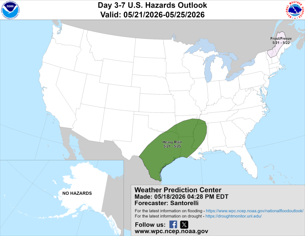
Above is a look at the U.S. Hazards Outlook from NOAA, highlighting areas of more impactful weather to be aware of over the next 3 to 7 days. The main area to watch is from south and eastern Texas into Louisiana, Arkansas, and nearby parts of the lower Mississippi Valley, where heavy rain will be possible from May 21 through May 25.
This does not mean it will rain the entire time, but this corridor could see multiple rounds of showers and thunderstorms, which may lead to localized flooding concerns, especially in spots that pick up heavier downpours over the same areas. Outside of that, the hazards map is pretty quiet overall, with the only other highlighted area being a frost/freeze risk across northern New England late this week.
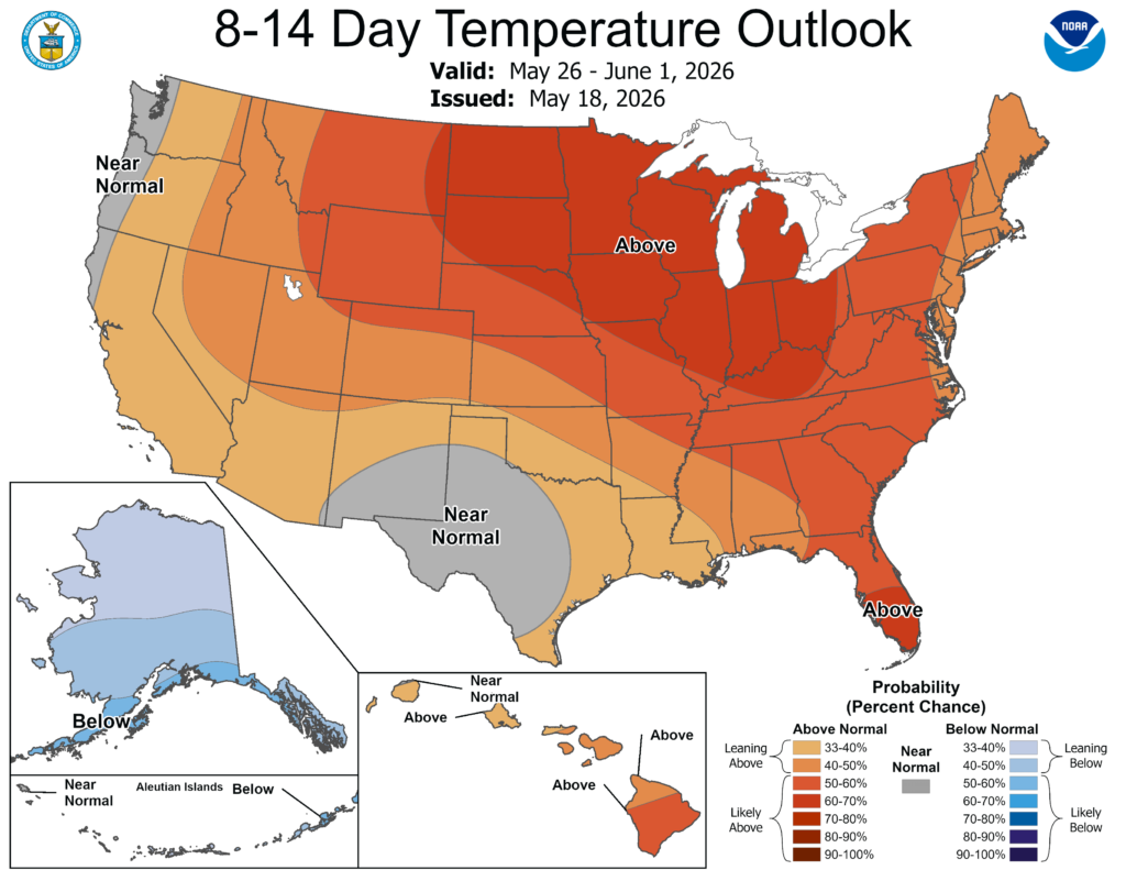
Looking ahead to the 8–14 day period, which would bring us into NEXT week, ridging looks to build across a large part of the central and eastern U.S., which is why the warmer-than-normal signal is so widespread.
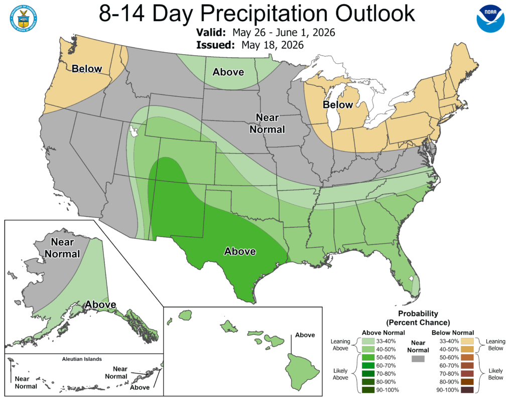
The more active pattern continues across the South. With some troughing hanging back toward the Southwest and Gulf moisture nearby, showers and storms should have a better chance to keep firing from Texas into the southern Plains and Southeast. Areas farther north look less active overall, with some drier signals showing up around the Great Lakes, northeast, and Pacific Northwest.
Thanks for tuning in to this National Forecast! Tune in to our local, tropical, and regional forecasts to stay updated on the latest!


