Happy Labor Day Weekend! We’re at the beginning of the month again, so let’s take a look at what we have in store for the next couple of weeks.
Drought Monitor
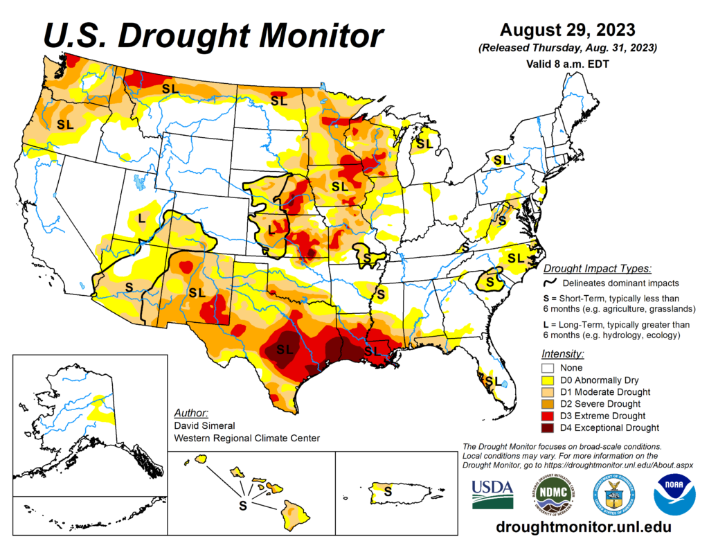
Our drought monitor is pretty alarming to say the least. Considering we had little to no rainfall for all of August, it’s no surprise we’re in such a state. Even with the past few days worth of rain, it won’t really be enough to change anything such as burn bans since most of the grass and a lot of plants have died due to the heat and lack of water. The CPC is also implying that the drought is going to persist for the month as well. Why? Let’s look at what’s to come this month.
Precipitation

Looking at the map above, we’re just east of being below our average precipitation for the month. Historically, September is a pretty dry month for most of the South. We don’t expect a lot of rain around harvest, but in this case, a lack of rain in an extreme drought is pretty serious. There seems to be a sliver of hope come near this weekend with a shortwave possibly providing some rain, however, it doesn’t look to be enough to make a huge difference.

Both the Euro and the GFS agree that there is a shortwave bringing in precipitation, however both are still off on the timing. Either way, this will bring a decent amount of rain, but it likely won’t be enough to ward off the burn bans. Unfortunately, this looks to be the last bit of rain we’ll get for a while too as we slip into a more linear atmosphere by the week after.
Temperatures

This month will also be a bit warmer than average as well. Another fairly strong ridge will develop over the southwestern US and will definitely have an effect on us for the next couple of weeks. We’ll have an overall drier heat with winds coming from the north and east.
Some slightly good news is that near the middle of the month, we’ll slowly, and I mean slowly, see temperatures start to wane.

Overall, this looks to be a fairly dry and hot month, though maybe not as miserable as August. Since rain is still low, heed the burn bans and please don’t cause any out of control fires. And be sure to stay hydrated during the day as heat indices will still reach the 100s for a while longer.
[wpcode id=”41179″]
Regional Day-to-Day Forecast
Tonight – A 20 percent chance of showers and thunderstorms before midnight. Mostly cloudy, with a low around 74. Southeast wind around 5 mph becoming calm.
Labor Day – A 40 percent chance of showers and thunderstorms, mainly after noon. Mostly cloudy, with a high near 91. Heat index values as high as 100. Light east southeast wind becoming southeast 5 to 10 mph in the morning.
Monday Night – A slight chance of showers in the evening. Patchy fog in the early morning. Otherwise, partly cloudy, with a low around 71. South southeast wind around 5 mph becoming calm in the evening.
Tuesday – Patchy fog before 8am. Otherwise, sunny, with a high near 94. Heat index values as high as 97. Calm wind becoming southeast around 5 mph in the morning.
Tuesday Night – Patchy fog before sunrise. Otherwise, mostly clear, with a low around 70. South wind around 5 mph becoming calm in the evening.
Wednesday – Patchy fog in the morning. Otherwise, sunny, with a high near 96. Calm wind becoming east around 5 mph in the afternoon.
Wednesday Night – Clear, with a low around 72. South southeast wind around 5 mph becoming calm.
Thursday – Sunny and hot, with a high near 98. Calm wind becoming northwest around 5 mph in the afternoon.
Thursday Night – Mostly clear, with a low around 72. South southeast wind around 5 mph becoming calm.
Friday – A 20 percent chance of showers and thunderstorms after 1pm. Sunny and hot, with a high near 98.
Friday Night – Mostly clear, with a low around 72.
Saturday – Sunny, with a high near 95.
Saturday Night – Mostly clear, with a low around 70.
Sunday – Sunny, with a high near 95.
[wpcode id=”41149″]


