While things are quite active out in the Plains today, tomorrow and Tuesday… for us Down South things will be a bit calmer. Sure, we may see an afternoon shower or storm here and there, but the risk for organized severe weather is pretty low.
At least for now.
By Tuesday night and Wednesday, it looks like a cold front will be close enough to push some clusters of storms through the area. These may feature a few severe storms. The main concern would be heavy rain, lightning, wind gusts up to 60mph, and small hail. Right now, I think the tornado threat should be on the very low end of the scale. Though, like usual, not fully zero.
The tough part? That front may “hang up” down here. That means lingering chances for rain and storms, each day, until it gets pushed out.
So we may have a soggy week ahead.

TODAY
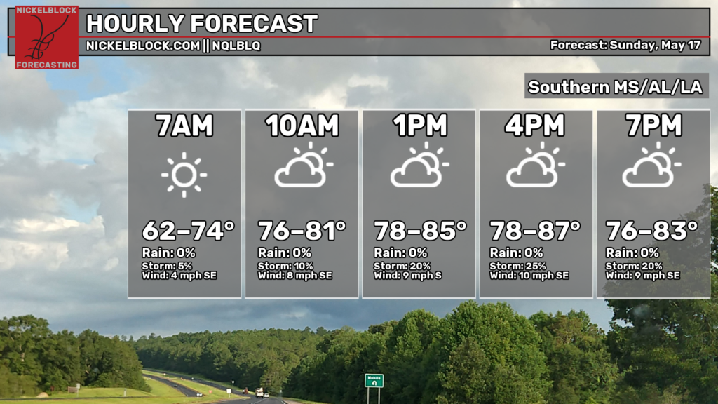
With high pressure in place (map below), we are still playing “the waiting game” for the next round of rain to arrive. Sure, there will be a 10-percent chance for rain in some spots, but aside from that it will feel like a pretty typical Early Summer kind of day.
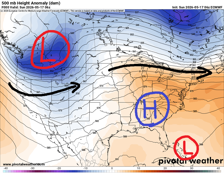
Looking at the 500mb map above you can see the ridge of High Pressure across the southeast with a new Low moving into the Pacific Northwest. That Low will be the system that tries to push a cold front through our area eventually. But today it is too far away to bother us.
While there is a little “L” out in the Bahamas, there is no need for any tropical-related concern (I’ll touch on that a bit later).
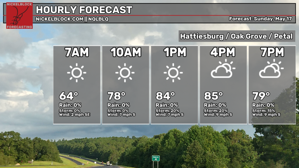
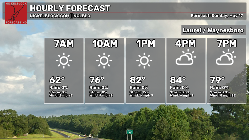
Looking at the city forecasts for today, for Hattiesburg, Oak Grove and Petal as well as Laurel and Waynesboro, you can see that a mixture of sun and clouds with highs in the mid 80s is the call there.
TOMORROW
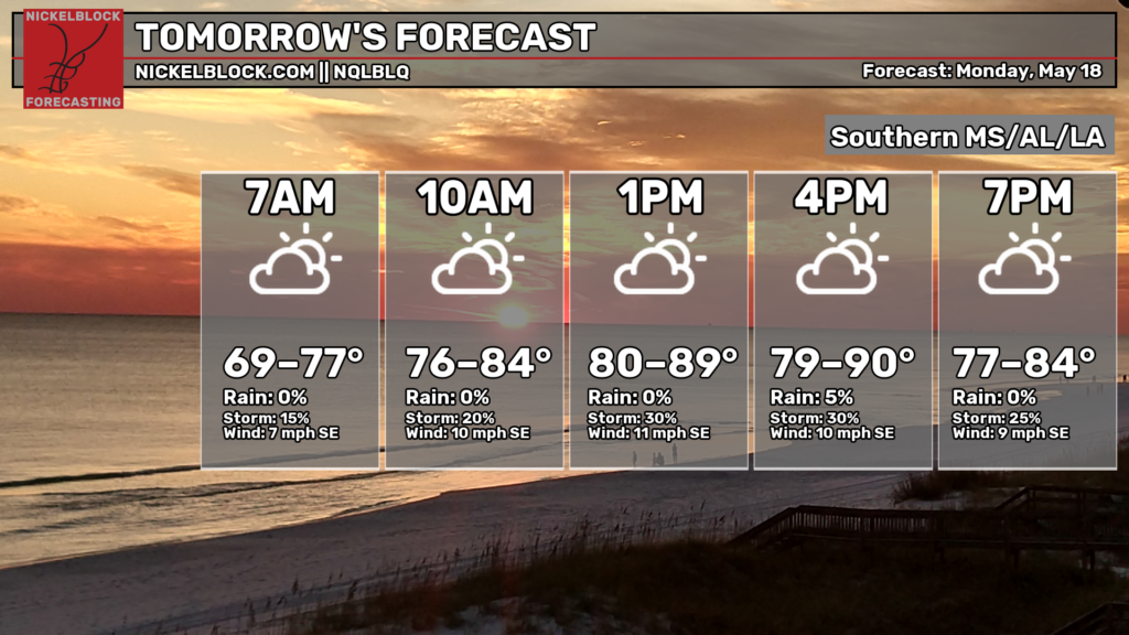
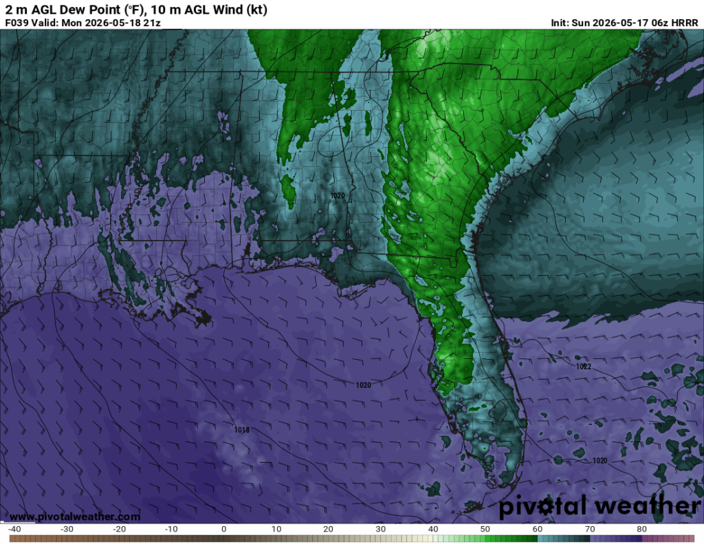
We get one more Earl;y Summer kind of day tomorrow. I think there may be a few spots with a 20-percent shot for rain, but otherwise it should be nice -albeit a bit humid- with afternoon highs ranging from the upper 70s closer to the waters in the north and near 90 toward Louisiana.
That humidity will make it feel even hotter. Looking at the dewpoint map below, you can see that the purples will be mostly across southern Louisiana, Mississippi and southwestern Alabama.
When you factor that in with the temperatures, the sunshine, and the light wind you’ll get an afternoon Experienced Temperature that is closer to 100F.
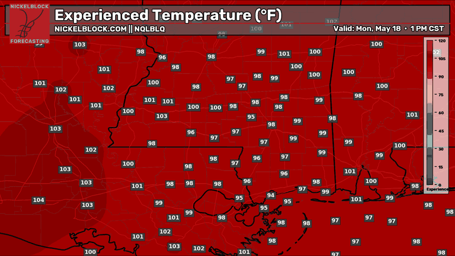
So if you have any plans to work outside or have any kids with a ballgame, make sure you are good an hydrated and seek out some shade when you can — it’ll be hot.

THE DAY AFTER TOMORROW
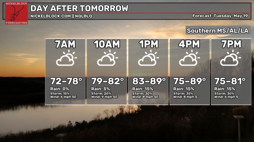
Tuesday is when things start to get a bit more interesting – particularly for our northwestern counties. As the front gets a bit closer, it’ll offer a bit more lift and a better shot for some rain. And a few storms, too.
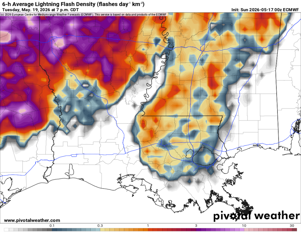
The lightning flash density map from teh ECMWF model (shown below) highlights that pretty well. Folks in Greene and Washington counties of Mississippi and Alabama don’t have as much to worry about as folks, in say, Rankin County.
Zooming out a bit, looking at the 700mb vertical velocity map, we can see how much bubbling motion there will be in the mid-levels. This 700mb map looks at the atmosphere up around 10,000ft (roughly). And inside the circle area on the map below we can see a mess of colors.
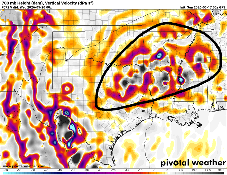
That mess of colors is a good indication of a very turbulent atmosphere where some areas have air quickly rising (making clouds and storms) and other area have air quickly sinking (in the wake of rain and storms).
But notice the biggest of the mess is back across parts of east Texas, a sliver of Oklahoma, all of Arkansas, northern Louisiana and northern Mississippi. So, for su, the chance for storms on Tuesday is “there” but not really all that high.

EXTENDED OUTLOOK
Once this front settles across the area though, it may be here for a while. There is some indication that we may be stuck in a bit of a “wetter” pattern for the next 10 days. That doesn’t mean we will see rain all of those 10 days in every spot. But it does mean we may hold on to a higher chance for rain each day. Especially compared to normal.
Once we get through this week, the model guidance that looks out into next week is still a bit soggy for us.
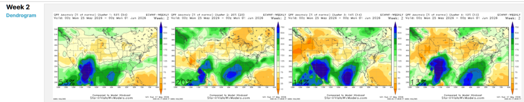
The maps above are “cluster data” from the VAREPS model. This is an ensemble model with 100 members. So, they take the model and they tweak knobs here and there at the start and let’er rip! This is a weather model that looks out 6 weeks into the future. It isn’t great with specifics like, “will it rain in Columbia or will it rain in Hattiesburg?” but it is pretty good at answering, “will it rain across the region?”
The “Cluster data” here takes all of the 100 members of the model. Then, it groups members that come up with the same/similar outcome into three or four bins.
Notice that all four bins say, “wetter than normal weather” for us.
TROPICAL NOTE
I mentioned the little area of low pressure out toward the Bahamas earlier. Given its location and the time of year, we aren’t too concerned about that “getting into the Gulf” right now. With a front in the area, even if it did get into the Gulf, it would right to the northeast along said front (that’s what tropical systems do) and away from us.
And while that isn’t something to worry about right now, there may be something to monitor from the Central American Gyre as we get toward the first week of June.
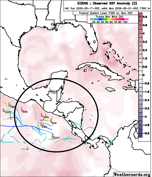
While, as of now, most of the Ls and lines you see are on the Pacific side, I think this may be an area where the weather models try to spit out some sort of tropical riff-raff in the coming days. So you may see stuff floating around on social media showing tropical systems and hurricanes in the Gulf.
For the next 7-10 days, you can simply ignore them.
Once we get into June it might be worth more attention.
But that said, if we still have this front laid up across the Gulf coast, the CAG can spit out as many Cat 5 hurricanes as it wants… they’ll never make it here. The front and the over-running upper-level winds will help to steer anything that could develop… away from us.
DAY-BY-DAY FORECAST
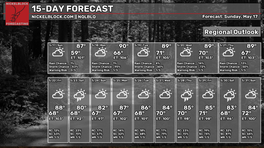
Today – A warm and quiet end to the weekend with plenty of sunshine around. Highs climb to near 85 with a light south breeze at 5 to 10 mph.
Tonight – A calm and fairly comfortable night ahead. Some patchy fog may develop late after 2am under partly cloudy skies. Low near 65.
Monday – Not a washout, but keep an eye on the sky during the afternoon. A few showers and thunderstorms may develop after lunchtime, with highs near 85 to 90. Morning fog fades quickly, followed by a mix of sun and clouds. Rain chance: 30%.
Monday Night – A lingering evening storm can’t be ruled out before things quiet down overnight. Mostly cloudy with lows around 65 to 70.
Tuesday – Another warm May day with a mix of sun and clouds. Highs push close to 90 for some folks, others in the mid 80s with a light southeast breeze. Chance for rain or storms around 10% to 20%
Tuesday Night – Mostly cloudy and mild overnight with lows near 65 to 70.
Wednesday – Heat and humidity continue building with highs near 90. A few afternoon thunderstorms may pop up after 1pm, but much of the day stays dry. Rain chance: 40%.
Wednesday Night – A stray evening shower remains possible before skies settle into a mostly cloudy night. Low around 65.
Thursday – Storms continue. Expect a mix of sun and clouds early, with showers and thunderstorms becoming more likely during the afternoon. High near 85. Rain chance: 60%.
Thursday Night – Scattered showers and storms continue into the evening and overnight hours. Low around 65.
Friday – An unsettled pattern sticks around with numerous showers and thunderstorms expected. Mostly cloudy and a bit cooler with highs near 86. Rain chance: 60%.
Friday Night – A few showers and storms may linger overnight under mostly cloudy skies. Low near 70.
Saturday – Wet weather hangs around into the weekend with additional showers and thunderstorms likely. Highs stay in the mid 80s. Rain chance: 50%.


