The Storm Prediction Center continues to monitor the region for the potential for severe weather.
From the SPC:
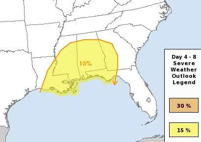
…Tuesday/Day 4 to Thursday/Day 6…
The medium-range models move an upper-level trough across the Four Corners region on Tuesday as southwest mid-level flow remains established from the southern Plains to the Ohio and Tennessee Valleys. A moist airmass should be in place in the lower Mississippi Valley where scattered thunderstorm development will be possible Tuesday. A severe threat may develop across parts of the Arklatex where instability and shear are forecast to be favorable for wind damage and hail. The chance for thunderstorm development is forecast to continue from Tuesday night into Wednesday across the Southeast as the upper-level trough moves into the central states. Strong deep-layer shear and moderate instability in the central Gulf Coast region could be sufficient for squall-line development as a cold front moves from west to east across the region. The front is forecast to reach the eastern Gulf Coast States on Thursday with a moist and unstable airmass in place ahead of the front. This combined with strong deep-layer shear associated with a broad mid-level jet, should be sufficient for a continued severe threat during the day on Thursday. Wind damage and hail will be possible from central and northern Florida northward into the Carolinas.
The highlighted area under a Slight Risk for severe weather on Wednesday has shifted a bit since yesterday, and will likely shift again.
As always, this far out is too early for specifics like which town will see the worst weather or who will see the highest chance for a tornado. All we know at this point is model guidance shows an atmospheric setup that will offer the chance for severe weather across the region between late Tuesday night and early Thursday morning.
While the SPC area has shifted, so too has the CIPS Analogs area – and percentages.
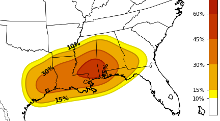
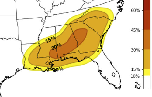
That 45% area would convert back to a Moderate or High Risk (4 out of 5, or 5 out of 5 on the 1 to 5 scale where 5 is the highest risk). But before you get too worried, yesterday the CIPS was showing this…
So there are still a lot of things to iron out. In fact, a great Rule of Thumb to remember is that any time you see that big of a swing from one day to the next, when looking at data more than five days out, it isn’t as much an indication that “things are definitely looking worse” as much as it is, “models are really struggling with this one.”
From the WPC:
Extended Forecast Discussion
NWS Weather Prediction Center College Park MD
211 PM EST Sat Feb 01 2020Valid 12Z Tue Feb 04 2020 – 12Z Sat Feb 08 2020
…Excessive Rainfall Threat for the
South/Southeast/Appalachians…
…Heavy Snow/Ice Risk from the Mid-Mississippi Valley
northeastward to the Northeast……Weather/Hazard Highlights and Guidance/Predictability
Assessment…Medium range forecast confidence remains above normal in the synnoptic flow pattern evolution Tue-Thu, but decreases next Fri-Sat amid growing forecast spread. The WPC medium range product suite was primarily derived from the reasonably comparable GFS/ECMWF days 3-5, then the more consistent GEFS/ECMWF ensemble means days 6/7. This maintains good WPC continuity.
Onshore flow/impulses running overtop a building western upper ridge will bring rounds of heavy precipitation to the Pacific Northwest next week that work inland across the northern Great Basin to the north-central Rockies. Locally heavy mountain snows are likely in this pattern. The impulses subsequently dig to the lee of the ridge to maintain/reinforce an ampified lead mid-upper level trough. This active trough will work through from West/Rockies Tue/Wed and Central U.S. Wed/Thu before ejecting over the East late week. Frontal wave developments and leading/increasing Gulf moisture inflow and instability in advance of amplified upper troughing and favorable upper jet flow favor an emerging threat for excessive rainfall, especially across the Southt/Southeast and into the southern Appalachians/southern Mid-Atlantic Tue-Thu. SPC also highlights a risk for severe weather shifting from the Lower Mississippi Valley to the Southeast during this period. On the north side of the precipitation shield, there is an increasing signal indicating that sufficient cold air will settle in place for a swath of heavy snow/wintry precipitation from the Mid-MS Valley to the Northeast.
Temperatures from the Southern Plains to the Mid-Atlantic will average 15 to 20 degrees above normal early-mid week, trending back towards normal following wavy cold frontal passage later week. Widespread record minimum temperatures are especially possible in this pattern. Temperatures in the west-central states will be much below normal Tue/Wed, but warm back to normal or slightly above normal by the end of the week as upper level ridging builds aloft.
Model Data
The European Model thinks this will be a multi-round low-burn event with a severe threat briefly on Wednesday.
Meanwhile the GFS model thinks we are going to get a fly-by of severe storms.
Neither are correct. And neither loo “worse” today than yesterday. Just different. I tend to think the models will get a much better handle on things overnight tonight and through the day tomorrow. As the next system gets to a place where weather balloons can actually sample the air nearby.
Early Thoughts
Yesterday, I mentioned that a blob in the Gulf may save south Mississippi from the worst of the weather but I’m starting to become a bit skeptical of of that outcome. I am starting to get a bit more concerned about flooding in the Gulf coast, too. Can’t predict where is going to see the most rain yet, but if things shake out like they could – with a 36 hour window of southwesterly flow over the top of a southerly fetch off the Gulf – the region could see some spots pick up as much as 3″ to 5″ of rain somewhere
But that is all TBD. In the meantime, we wait.\


