Saturday night and into Sunday morning Louisiana, Southern Mississippi and southern Alabama will be dealing with the opportunity for severe weather.
Scenario
An area of low pressure will swing through Texas and move across the lower Mississippi valley and into southern Tennessee and northern Alabama. As it moves through a warm front will allow moisture to surge northward out of the Gulf of Mexico. Behind that surge of moisture, a Pacific cold front will push through the area sparking showers and thunderstorms from Dallas, Texas to Mobile, Alabama.
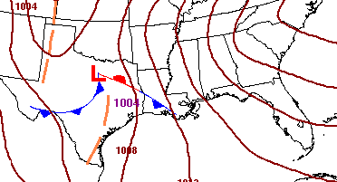
While a bulk of the severe weather will occur in Texas on Saturday afternoon, storms will begin to fire in the evening across Louisiana, southern Mississippi and eventually Alabama.
The current proverbial “wrench” in the forecast is the possible development off the coast that may inhibit instability across the Deep South. Without the necessary instability storms may never develop into truly “severe” storms though most storms would still be accompanied by heavy rain, frequent lightning, gusty wind and a few brief and weak tornadoes.
As the cold front moves out of the area on Sunday, skies will clear and temperatures will be mostly unaffected.
Breakdown
Texas
Saturday before 4pm
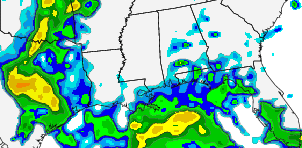
Mostly cloudy with scattered showers and thunderstorms from Dallas to Abilene to Corpus Christi and points in between. Storms will have the potential to turn severe with heavy rain, large hail, damaging wind and isolated tornadoes possible.
Saturday after 4pm
Scattered showers and thunderstorms from Dallas to Austin to Houston and points nearby. Storms will have the tendency to be supercellular in nature and will have the potential to turn severe. The main threats will be heavy rain, large hail, damaging wind and isolated tornadoes possible. The SPC is current worried about a stronger line of storms developing during this time that could pack very strong straight-line winds.
Louisiana and Mississippi
Saturday around 4pm
Mostly cloudy with isolated showers and storms across Louisiana and southwestern Mississippi. Some storms that develop will have the possibility of turning severe. The amin threats will be heavy rain, gusty wind, and frequent lightning.
Saturday around 9pm
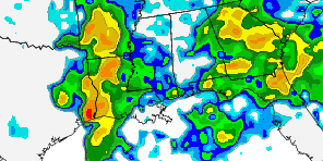
Scattered showers and storms now moving from south to north across the region. Model guidance is in good agreement that starting near this time that coverage of thunderstorm activity will become more widespread. Storms that develop at this time will have the possibility of turning severe. The main threats will be heavy rain, damaging winds, frequent lightning and isolated brief tornadoes.
Sunday around 2am
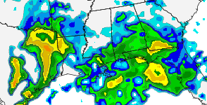
Numerous storms will dot the landscape. Storms will have the potential to turn severe, too. The main threats will be heavy rain, damaging winds, frequent lightning and isolated tornadoes. This time frame will be the most likely to produce severe weather across the area. Embedded supercells would be the most potent storms.
Alabama
Sunday before 2am
Mostly cloudy with isolated showers and storms. Most of these storms would be below severe limits with heavy rain, gusty wind and frequent lightning as the main concern.
Sunday after 2am
Numerous storms will dot the landscape. Storms will have the potential to turn severe, too. The main threats will be heavy rain, damaging winds, frequent lightning and isolated tornadoes. This time frame will be the most likely to produce severe weather across the area. Embedded supercells would be the most potent storms.
Concerns
Convection off the Gulf Coast may inhibit the development of sufficient instability for severe weather to occur in Louisiana, Mississippi and Alabama. Right now, the models are in consensus that CAPE values will be below 1,000 J/KG – generally – east of Houston, Texas.
If this holds true the threat for tornadoes would still exist, but would be lowered as would the threat of embedded supercells with damaging straight-line RFD winds.
That said, trends have been to increase instability along the coast through the night and lower the level of convection off the coast. Should the coastal convection not materialize and the low-level jet become established, the threat for more widespread severe storms would increase.
The following is a severe weather threat index for the Pine Belt of Mississippi. Also below a short list of a few severe weather parameters and the key to understand what they mean.
The chance that a storm reaches the base-level to be considered “severe” (60mph wind / >1″ hail) is indicated on the map. And while this is not an “optimal” setup as shown by the numbers, it does still fall within the “possible” category.
One thing to note is that if instability rises – due to an increase in temperature/moisture at 850mb due to the low-level jet, these numbers, and therefore the threat of severe weather, increase – some drastically.
What we know, What we don’t know
We know:
Storms will develop Saturday in Texas and along the gulf coast to Alabama
Some storms will become “severe” with heavy rain, damaging wind, some hail and the possibility of an isolated tornado
Storms will start around 2pm in Texas and last past 7am in Alabama
We don’t know:
Exact time frame for storms in specific areas due to Gulf of Mexico convection
Severity the storms will reach
Size or strength of possible tornadoes
Level of instability storms will be able to work with in Mississippi and Alabama
Stay alert Saturday and into Sunday. Have a NOAA Weather Radio near you or at the least a good app on your smartphone. And as always, check back for updates!


