FRIDAY 12:30PM UPDATE:
It looks like the Storm Prediction Center is seeing similar things from the same data I show below and came to a similar consensus. The SPC has extended the Enhanced Risk area a bit to the east and south. And the Slight Risk was pushed east, too.
ORIGINAL: Alrighty, friends, we are within the 48 hour window, and now we can start to estimate and forecast for specifics. Not crazy specific, like which house will see a tornado, but specifics like XX area has a better chance for tornadoes than YY place. Or the flooding risk in AA region is lower than BB area.

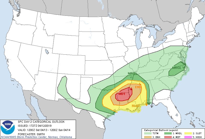
To start. The Storm Prediction Center has issued a Moderate Risk for severe weather for parts of Louisiana and Arkansas. A reminder that the Moderate Risk is a 4-out-of-5 on the 1-to-5 scale where 5 is the highest risk. There is an Enhanced Risk for parts of Texas, Louisiana, Mississippi and Arkansas. A Slight risk for other areas in those same states, as well as Alabama. And a MArginal Risk include all of those states plus parts of Tennessee and Oklahoma.
For this discussion, I will focus on Louisiana, Arkansas, Mississippi and Alabama.
Courtesy: PivotalWether.com // via GIPHY
That is the first hi-res estimate of the track of all the storms – from west to east – across the Gulf Coast from the HRW WRF-ARM model. It may not look that ominous or menacing, but this particular model’s attempt to produce a reflectivity (futurecast-looking) product often under-represents the size and scope of storms.
The reason I show it is because I think it highlights the most likely scenario for storm mode and formation.
Timeline & Threats
Storms will begin to develop Saturday afternoon – between 1p and 3p – in the warm-sector of the next system across parts of extreme eastern Texas, Louisiana, southern Arkansas and extreme western Mississippi. The storms will cluster into a broken line of storms by 7pm across parts of central Arkansas and Louisiana as a cold front swings through those areas.

The broken line of storms will continue to congeal into a full, unbroken line of storms as it pushes across Mississippi between 8pm and 3am. And then through Alabama between 3am and 9am.
The clusters of storms earlier in the day will be capable of producing heavy rain, frequent lightning, wind gusts up to 70mph, hail up to the size of half dollars, and will also be able of producing tornadoes. Given the atmospheric setup having a handful of tornadoes – from different storms in different places – all happening at the same time is possible.
As the storms start to form a broken line, the tornado threat will diminish a bit as will the hail threat. But the wind threat will hold – and perhaps even increase slightly. That said, and this is very important, the tornado threat will never fall to zero within the broken line of storms.
As the line move through Mississippi, individual storms within the line may have enough spin to produce tornadoes. But the main threat will be heavy rain, frequent lightning and wind gusts up to 70mph. Once the line full develops, it looks like the hail threat will diminish quite a bit.
Once the line gets into Alabama, storms will continue to produce heavy rain, frequent lightning and gusty wind. Tornadoes can (still) not be ruled out. The good news is that as we get closer to sunrise, the potency of the storms should ease off a bit. But “easing off” of a potency in a line of storms with 70mph wind possible still means these will have some bite.
Plus, there may be an increase in severity of the storms after 9am. So depending on how fast the line move through alabama, there may be places that see a bump in severe weather Sunday morning.
Where will the worst weather happen?
Before I get into this, I want to really – reaalllyyy! – remind people that just because forecast data or a forecast shows a certain area with a higher risk for stronger storms, does not mean other places will not see stronger storms. Spot-forecasting for severe weather is difficult, and rankly, a very imperfect exercise. I try my best, but I will never be 100-percent correct. I may not even be 50-percent correct some days.
I just want to offer that full disclosure first.

Data from multiple models shows that the Storm Prediction center is spot on with their forecast. This shouldn’t be a surprise, either. The SPC is a group of fantastic meteorologists supported by decisions made by meteorologists at the local level at the local National Weather Service offices. TRuly, their forecasts are often superb.
The maps above, though, is an attempt by the model to isolate where the highest “Updraft Helicity” will be during those time periods. And updraft helicity is a measurement of spin within an updraft. And a spinning updraft is one that can sustain larger hail, produce stronger straight-line wind at the surface, and can be apart of the tornado-producing process.
Once we start to get into the evening and the storms shift east, the threats will change (as noted above).

The above map shows that – at different times – the areas where given the available data, I think the stronger storms will occur.
The grey area in Louisiana and Arkansas highlights the area of concern in the afternoon and early evening. The area in south-central Mississippi highlights the area of concern for the hours of 9pm through 3am. And the grey area in Alabama highlights the area of concern from 3am through 9am.
Again, I want to stress, if you are outside of these areas you are not “in the clear” by any stretch. And if you are in the area, this doesn’t guarantee severe weather or tornadoes.
All I’m trying to do is highlight the areas – given the available data – where within the SPC’s outlook that I believe the stronger storms will develop and persist.
How strong will the tornadoes be?
Will? I can’t answer that. How strong could the tornadoes be? I can give that shot. Rough estimates, based on proxies and some preliminary research, suggest that during the afternoon that up to EF-4 tornadoes will be possible. During the late evening and overnight that up to EF-3 tornadoes will be possible, and early in the morning through mid morning that EF-2 tornadoes will be possible.
Another reminder: Possible does not mean likely. Just because the atmosphere can support something, doesn’t mean it will produce something.
As an a analogy: I can carry a cake, but I can’t bake a cake. If you give me a cake, I can move it around. But I can not create a cake.
That is what the data is telling us about the atmosphere on Saturday. It can “carry” up to those strength tornadoes, but data can’t tell us if the atmosphere actually knows if it can “bake” a tornado of that strength. That is decided on very small, short-term timescales (like, in the final hours before storms begin)
The Recap
Storms start Saturday afternoon across parts of Louisiana and Arkansas and push east through Mississippi and into Alabama. Given the atmospheric setup the Storm Prediction Center has issued a handful of Risk Levels for those areas. The highest issued Risk Level being a Moderate Risk for parts of Louisiana and Arkansas. A reminder that the Moderate Risk is a 4-out-of-5 on the 1-to-5 scale where 5 is the highest risk.
The main concerns from storms, all across this region, are heavy rain, frequent lightning, wind gusts up to 70mph, hail up to the size of half dollars, and tornadoes. The timeline put the beginning of storms around 3pm in Texas, Louisiana and Arkansas. The storms move into Mississippi around 8pm. And move into Alabama around 3am.


