Yeah, things may not shake out to be quite as nice next week. While this week features sunshine, highs in the 70s and dry air. Next week looks to feature humidity, rain, and storms. In short: The March 15th – March 20th timeframe is look a bit wetter than average.
Right now, it looks like two systems will play a role in the extra chance for rain. One shows up Sunday and into Monday and another arrives by Wednesday and lingers into Thursday.
The setup
Early data is still a little loose on specifics, but the general idea is starting to shake out that a dryline-induced line of storms will press across Texas, Louisiana and fall apart across Mississippi and Alabama during the Sunday/ Monday timeframe.
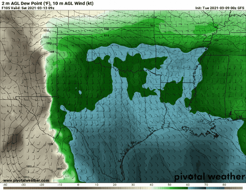
You can see the dryline pressing across Texas and into Louisiana, Mississippi and Alabama in the above GIF. The greens and blues indicate rich moisture. The browns and lighter colors indicate drier air.
The difference between the two air masses – very sharp in New Mexico and west Texas – is known as the dryline. And the potency of the dryline, and any storms associated with it, is directly related to how sharp of a contrast it is from one side to the other.
So, as you can imagine, as the dryline moves east and the line isn’t as sharp anymore, it may lose some punch.
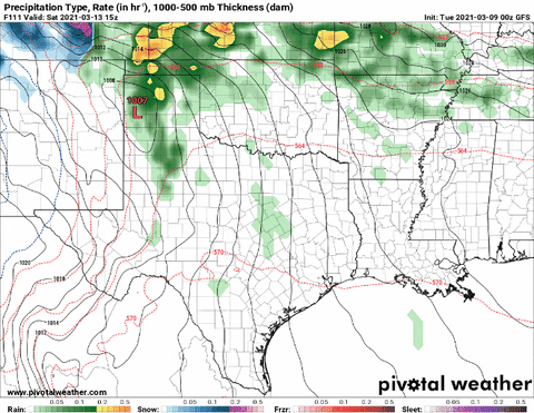
And hey, whaddya know! The line starts to fall apart as it moves east.
But that is when the second system dives into the Rockies from the Pacific Northwest.

You can sys that the first system (1) turns north while the second system (2) dives in behind it. This may lead to a merging of the two systems around the Colorado, Wyoming, Nebraska area (and may eventually result in a ton of snow for that area).
As the two systems merge, they will then push into the upper midwest shoving a cold front through the Gulf Coast Tuesday and into Wednesday. That will lead to more rain. Some of it may linger into Thursday.
Severe Weather Risk
So far, the severe weather risk appears to be on the lower end of the scale. The Storm Prediction Center has outlined parts of the are with a Slight Risk on Sunday and into Monday.


Notice that the severe risk area lines up with the dryline that is marching across the region. And that most of the severe weather risk will be north and northwest of the Gulf Coast region.
By Monday and into Tuesday, it looks like the risk for severe weather should be rather minimal, but I would bet that the SPC will peg parts of the region with a Marginal Risk for severe weather.
The main concerns – regionally – would be for heavy rain, gusty wind (up to 60mph), frequent lightning, hail up to the size of half-dollars, and a few tornadoes. Anything more specific than that, at this point, is an unknown.
Flooding risk
It depends. Regionally speaking, the threat for widespread flooding, given the available data is on the low end of the scale. Thankfully the region has been allowed to dry out during the past few days. And with a few more dry day to come, it looks like the threat for widespread flooding will be minimal.
The only asterisk I will add to that is… localized flooding may be a concern. Places where storms “train” and drop heavy rainfall continuously for hours may be a concern within this atmospheric setup. It is worth watching in the coming days, but not something to worry about at this point.
The Bottom Line
Next week looks to feature two chances for rain. One appears to arrive Sunday & Monday. The other looks like it will arrive Tuesday & Wednesday. The second one may even linger into Thursday. A third chance for rain may even arrive by the end of next week on Sunday, but that is still a bit up in the air.
Between Sunday (3/14) and Saturday (3/20), prepared to be stuck inside at least two days next week due to rainfall. And possibly a third. If you have outdoor plans scheduled, start thinking about backup plans, but don’t change plans yet.
Severe weather is possible, but the threat is pretty low. It looks like we will have to see the right things happen at the right times in order to shake out a severe storm if things play out as anticipated. Same wiht flooding.
Just keep tabs on the forecast in the coming days. We will do our best to fine-tune things and get a bit more precise in the coming days.


