Good morning, and happy Tuesday!
Hot and muggy conditions are likely to continue through Wednesday before a boundary moves into the region, bringing with it some cooler temperatures and greater chances for showers and thunderstorms.
Current Synoptic Picture

Right now, with a large upper-level ridge centered over the Texas and Oklahoma Panhandles and an upper-level low over the Northeast, the Southeast is caught between the two features. With the states like Louisiana and Mississippi still feeling the impacts of the strong ridge, meanwhile states like Georgia and South Carolina have already begun to cool down courtesy of the upper-level low.
As we progress through the week, however, the upper-level ridge will be forced back west as the upper-level low strengthens, cooling down our temperatures and increasing our chances for rain as we close out the week and head for the weekend.
Because of this, we can roughly split this forecast up into two parts, the heat and humidity today and tomorrow, and the cooler and wetter period from Wednesday night onward.
Today and Tomorrow
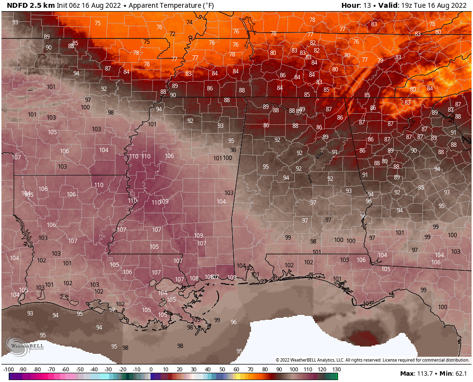
Today and tomorrow will certainly bring the heat, as a plume of warmer 850mb temperatures has moved into the region from the west. This will result in highs in the mid-90s and feels-like temperatures approaching 110F! For this reason, the NWS has issued heat advisories across the region. Widespread showers and thunderstorms also look unlikely during this time, with most of the activity to the north of the area – leaving only isolated storms forecast for the region both today and tomorrow.

Today appears to be the warmest of the two days, with an approaching boundary and cooler 850mb temperatures working in our favor to make things a bit less oppressive for Wednesday.


Nonetheless, the hot temperatures and high dewpoints will result in apparent temperatures well above 100F once again. The real relief doesn’t come until Thursday, as a cooler air mass from the north works its way into the region…
Thursday through Early Next Week
Thursday will bring with it some much-needed cooler temperatures, as well as an increased chance for showers and thunderstorms as the boundary between the cooler air mass underneath the strengthening upper-level low to our north and the warm air from the upper-level moves over the region. This will result in temperatures in the mid-80s as opposed to the mid-90s through at least Friday.

By Saturday, the upper-level low beings to pull out of the region and retreat back to the north and west, allowing the sub-tropical ridge to build back into the Southeast, albeit slowly. This will allow for temperatures to creep back up into the upper-80s and possibly the low 90s come Sunday, before the upper-level trough slides back into the region for a time early next week.


However, this boundary won’t just bring a shot of cooler temperatures, but also some rain to the area. According to the GEFS 7-day precipitation anomaly from this Thursday into next Thursday will result in much of the Southeast seeing above-average rain.

Day-to-Day Forecast
Today
Partly cloudy with a 20-percent chance of a storm throughout the day, increasing to a 50-percent chance late this evening. Expect highs in mid-90s with feels like temperatures of 100-110F.
Tomorrow
Partly cloudy with a 20-percent chance of a storm throughout the day, increasing to a 40-percent chance late in the evening. Expect highs in the low-to-mid-90s with feels like temperatures of 100-110F.
Thursday
Mostly cloudy to cloudy skies expected with a 80-percent chance of showers or thunderstorms throughout the day. Expect highs in the low 80s.
Friday
Mostly cloudy to cloudy skies expected with a 70-percent chance of showers or thunderstorms throughout the day. Expect highs in the low 80s.
Saturday
Partly to mostly cloudy skies expected with a 50-percent chance of showers and thunderstorms, especially in the afternoon. Expect highs in the low-to-mid-80s.
Sunday
Partly to mostly cloudy skies with a 50-percent chance of showers and thunderstorms, especially in the afternoon. Expect highs in the mid-80s.
Monday
Partly to mostly cloudy skies with a 60-percent chance of showers and thunderstorms. Expect highs in the low-to-mid-80s.


