Good morning, everybody! This forecast is going to be very similar to the last, right down to the advisories, so let’s start with those.
Most importantly, the same areas are under a Heat Advisory for the second day in a row- the Mississippi Counties along the Louisiana border, between Vicksburg and Natchez. This advisory will run until 7pm tonight.

The majority of the area is forecast to see Heat Indices around 105 this afternoon, but areas in the Advisory may see up to 110.
Looking at the upper level wind maps, we have a very similar pattern to what we’ve been seeing.

This upper level map for this morning at 7am, shows a pretty stout ridge from Oklahoma and Texas into the Carolinas. With the ridge axis, or area of higher pressures, over this region, we’re going to see warmer weather, and lower rain chances during the day today.
Today, because the ridge is pretty close to centered over the area, we should start out clear and dry this morning, before the afternoon heating leads to very isolated thunderstorms. No severe weather is expected at this time, though the stronger storms can produce strong wind gusts at a moment’s notice.
Most of us will stay dry, as is usually the case with these afternoon summer thunderstorms.

The HRRR, for this afternoon at 7pm, should have a pretty good handle on the storm chances. This is what we mean by a 20-percent, since it seems that most people will be dry, and the storms will be few and far between.
The exact placement of storms isn’t certain, but they aren’t likely to cause big impacts during the day.
Going into the weekend, although a weak surface cold front will probably approach the area, we won’t really be feeling any effects from it, other than an increased chance of thunderstorms.
Since the majority of our flow is out of the South, it will be reinforcing our warm, moist airmass with more humid Gulf Coast air, cutting out any chances for any cool air to actually make a move into this area.
The upper-level support still suggests a ridge, and our airmasses aren’t changing – that is to say, the warm and humid air isn’t going anywhere else so our weather won’t be too unsettled.
Though the chances of rain are higher for Friday and Saturday, the days should be pretty similar to what we’ve seen, with clear mornings and thunderstorm chances picking up in the afternoon.
For this period as well, severe weather is not in the forecast. Wind shear will increase, and there is a chance that some thunderstorms could become sustained and form a longer lasting complex, known as an MCS, but we aren’t expecting that. They are hard to predict so we’ll be keeping an eye out for stronger storms.

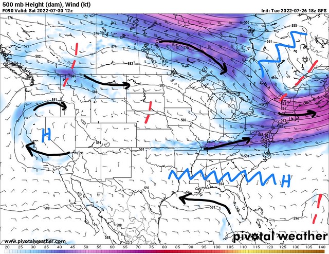
This medium-range map is valid for the first 5 days of August. During this upcoming period, the only story is the continued heat, which has been the story this whole summer. Though it hasn’t been excessively hot, we’ve seen a long, drawn out stretch of above average temperatures, and that shows no sign of stopping any time soon.
A pretty strong and unwavering upper=level ridge will make sure of that. Also of note? The Tropical Atlantic continues to be uncharacteristically quiet, and the strong SE ridge will help keep any potential systems away from the coast. The tropical weather discussion being shared later will have more specific details, but I’m excited to have no tropical news to report!
Day-to-Day Forecast
Today
Mostly sunny, with a 20-percent chance of an isolated afternoon thunderstorm. Highs in the mid-90s. The heat index may reach 105F.
Tomorrow
Mostly sunny, with a 30-percent chance of an isolated afternoon thunderstorm. Highs in the mid-90s. The heat index may reach 105F.
Friday
Partly cloudy, with a 40-percent chance of afternoon thunderstorms. Highs in the low-90s.
Saturday
Partly cloudy, with a 50-percent chance of afternoon thunderstorms. Highs in the low-90s.
Sunday
Partly cloudy, with a 30-percent chance of afternoon thunderstorms. Highs in the mid-90s.
Monday
Mostly sunny, with a 20-percent chance of afternoon thunderstorms. Highs in the mid-90s.
Tuesday
Partly cloudy, with a 30-percent chance of afternoon thunderstorms. Highs in the low-90s.


