It’s always good to hear that tropical activity in the Atlantic has been quiet, and such has been the case this July; however, it isn’t July that’s known for hurricanes and tropical storms. Historically August, September, and October record the most tropical activity each year and are nearly here. Meanwhile the East Pacific continues to have an active hurricane season, with one disturbance in particular ready for further tropical development.

1) The Saharan Air Layer (SAL) remains persistent across the Atlantic Ocean aiding in the hindrance of tropical development and activity throughout the Main Development Region (MDR) for tropical cyclones.
2) A weak tropical wave is moving eastward across the Florida peninsula through the Gulf of Mexico and will enhance thunderstorm activity in the Gulf and along the Gulf Coasts as it makes its way to Texas. No further development of this wave is expected.
3) An area of unorganized thunderstorms (Invest 97E) in the East Pacific is moving into favorable conditions for tropical cyclone development and may become a tropical depression within the next 24 hours.

Invest 97E is experiencing some shear on the south and southwestern side of the storm, but it isn’t affecting the storm too much due to the direction of the shear helping the storm’s outflow. Throughout this week the storm should organize more and face less shear overall as it heads west-northwestward into more favorable conditions.

97E will face some dry air from its northwest as it moves through the Pacific, but will likely remain a very moist tropical system thanks to the abundance of moisture from the Intertropical Convergence Zone (ITCZ). The above image has the ITCZ highlighted along with a weak tropical wave out ahead of the main storm, both being colocated along the ITCZ. This will allow 97E to draw a surplus of moisture as it further develops and strengthens into a tropical cyclone.
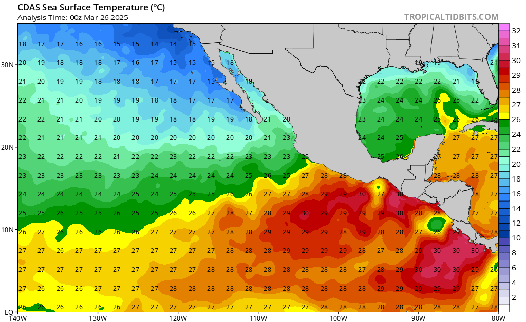
The heat stored in the ocean acts as fuel for tropical cyclones, and sea surface temperatures (SSTs) in the East Pacific are very warm and conductive of tropical intensification of 97E, with temperatures in excess of 29C (well above the 26C threshold for cyclone development).

Thankfully, Invest 97E is not expected to journey closer to land as it develops. The main impacts from this storm will be felt along the SW coasts of Mexico where rough surfing conditions and lift-threatening rip currents could be present from storm-generated swells.

The above image is a collection of model intensity forecasts from different weather models predicting the strength of the tropical system over the next several days. The consensus is that the storm will strengthen to tropical cyclone strength within the next 24 hours and possibly become a high-end tropical storm or category 1 hurricane sometime this weekend. Beyond that, the storm is expected to trek farther away from land, eventually experiencing more hostile conditions and cooler SSTs.


