I’ve received a ton of interest about how Hurricane Delta is going to impact each specific town in the Pine Belt. And while I can offer this information, it won’t be terribly precise AND accurate. It will either be one or the other.
Attempting to determine how a 300-mile wide hurricane is going to affect two towns – within 30 miles of each other – differently, with both precision and accuracy, during the next 30 hours is a lot like trying to tell the difference in eye color between two kids on a moving school bus that is 13 miles away.
So we have to pick precision or accuracy. I would rather be accurate. So these forecasts may not be as precise as you desire. But it isn’t for a lack of effort. The desired information is just simply impossible to ascertain.
On top of the concerns I have about precision, this forecast is likely to change during the next six hours. And then again in another six hours. Then three hours after that. And then every hour after that. Then it will change by the minute leading up until the weather is directly on top of your town.
That is the other reason precision is less important this far out in time.
But hey, let’s give it a shot!
Right now
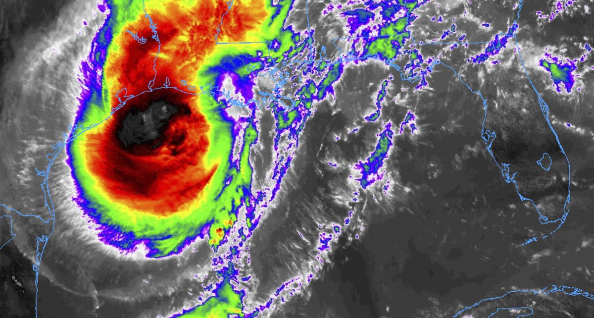
SUMMARY OF 100 PM CDT
LOCATION…28.7N 93.6W
ABOUT 80 MI…130 KM SSW OF CAMERON LOUISIANA
MAXIMUM SUSTAINED WINDS…110 MPH…175 KM/H
PRESENT MOVEMENT…NNE OR 15 DEGREES AT 14 MPH…22 KM/H
MINIMUM CENTRAL PRESSURE…963 MB…28.44 INCHES
Forecast fromt eh NHC

Northern areas
Quitman
Timeline
Friday 4pm – 10pm: Passing showers, Wind gusts up to 30mph as the first rainbands start to move through the area
Friday 10pm – Saturday 4am: Heavy rain at times, wind gusts up to 60mph
Saturday 4am – Saturday 10am: Heavy rain at times, wind gusts up to 60mph and the potential for tropical tornadoes
Saturday 10am – 4pm: Heavy rain at times, wind gusts up to 40mph
Saturday 4pm – 10pm: Mostly cloudy, wind gusts up to 30mph, drying out
Expectations
– There will be some localized flooding, with water coming up in people’s yards and the creeks may rise a bit for a short period of time during some of the heavy rain within the rainbands.
– Power outages will be likely. Prepare to be without power for up to 6 hours. The combination of a constant breeze and higher gusts as well as some of the rain means trees are likely to come down. On top of that, tropical tornadoes will be possible within some of the rainbands.
– Based on the latest available data, this will not be a widespread catastrophic event for our area. But a some places will still see damage from gusty wind, downed trees and possible tornadoes.
Bay Springs
Timeline
Friday 4pm – 10pm: Passing showers, Wind gusts up to 30mph as the first rainbands start to move through the area
Friday 10pm – Saturday 4am: Heavy rain at times, wind gusts up to 60mph
Saturday 4am – Saturday 10am: Heavy rain at times, wind gusts up to 60mph and the potential for tropical tornadoes
Saturday 10am – 4pm: Heavy rain at times, wind gusts up to 40mph
Saturday 4pm – 10pm: Mostly cloudy, wind gusts up to 30mph, drying out
Expectations
– There will be some localized flooding, with water coming up in people’s yards and the creeks may rise a bit for a short period of time during some of the heavy rain within the rainbands.
– Power outages will be likely. Prepare to be without power for up to 6 hours. The combination of a constant breeze and higher gusts as well as some of the rain means trees are likely to come down. On top of that, tropical tornadoes will be possible within some of the rainbands.
– Based on the latest available data, this will not be a widespread catastrophic event for our area. But a some places will still see damage from gusty wind, downed trees and possible tornadoes.
Magee
Timeline
Friday 4pm – 10pm: Passing showers, Wind gusts up to 30mph as the first rainbands start to move through the area
Friday 10pm – Saturday 4am: Heavy rain at times, wind gusts up to 60mph
Saturday 4am – Saturday 10am: Heavy rain at times, wind gusts up to 60mph and the potential for tropical tornadoes
Saturday 10am – 4pm: Heavy rain at times, wind gusts up to 40mph
Saturday 4pm – 10pm: Mostly cloudy, wind gusts up to 30mph, drying out
Expectations
– There will be some localized flooding, with water coming up in people’s yards and the creeks may rise a bit for a short period of time during some of the heavy rain within the rainbands.
– Power outages will be likely. Prepare to be without power for up to 6 hours. The combination of a constant breeze and higher gusts as well as some of the rain means trees are likely to come down. On top of that, tropical tornadoes will be possible within some of the rainbands.
– Based on the latest available data, this will not be a widespread catastrophic event for our area. But a some places will still see damage from gusty wind, downed trees and possible tornadoes.
Near Highway 84
Monticello
Timeline
Friday 4pm – 10pm: Passing showers, Wind gusts up to 30mph as the first rainbands start to move through the area
Friday 10pm – Saturday 4am: Heavy rain at times, wind gusts up to 60mph, and the potential for brief tropical tornadoes west of I-59
Saturday 4am – Saturday 10am: Heavy rain at times, wind gusts up to 60mph and the potential for tropical tornadoes east of I-59
Saturday 10am – 4pm: Heavy rain at times, wind gusts up to 40mph
Saturday 4pm – 10pm: Mostly cloudy, wind gusts up to 30mph, drying out
Expectations
– There will be some localized flooding, with water coming up in people’s yards and the creeks may rise a bit for a short period of time during some of the heavy rain within the rainbands.
– Power outages will be likely. Prepare to be without power for up to 6 hours. The combination of a constant breeze and higher gusts as well as some of the rain means trees are likely to come down. On top of that, tropical tornadoes will be possible within some of the rainbands.
– Based on the latest available data, this will not be a widespread catastrophic event for our area. But a some places will still see damage from gusty wind, downed trees and possible tornadoes.
Collins
Timeline
Friday 4pm – 10pm: Passing showers, Wind gusts up to 30mph as the first rainbands start to move through the area
Friday 10pm – Saturday 4am: Heavy rain at times, wind gusts up to 60mph, and the potential for brief tropical tornadoes west of I-59
Saturday 4am – Saturday 10am: Heavy rain at times, wind gusts up to 60mph and the potential for tropical tornadoes east of I-59
Saturday 10am – 4pm: Heavy rain at times, wind gusts up to 40mph
Saturday 4pm – 10pm: Mostly cloudy, wind gusts up to 30mph, drying out
Expectations
– There will be some localized flooding, with water coming up in people’s yards and the creeks may rise a bit for a short period of time during some of the heavy rain within the rainbands.
– Power outages will be likely. Prepare to be without power for up to 6 hours. The combination of a constant breeze and higher gusts as well as some of the rain means trees are likely to come down. On top of that, tropical tornadoes will be possible within some of the rainbands.
– Based on the latest available data, this will not be a widespread catastrophic event for our area. But a some places will still see damage from gusty wind, downed trees and possible tornadoes.
Laurel
Timeline
Friday 4pm – 10pm: Passing showers, Wind gusts up to 30mph as the first rainbands start to move through the area
Friday 10pm – Saturday 4am: Heavy rain at times, wind gusts up to 60mph, and the potential for brief tropical tornadoes west of I-59
Saturday 4am – Saturday 10am: Heavy rain at times, wind gusts up to 60mph and the potential for tropical tornadoes east of I-59
Saturday 10am – 4pm: Heavy rain at times, wind gusts up to 40mph
Saturday 4pm – 10pm: Mostly cloudy, wind gusts up to 30mph, drying out
Expectations
– There will be some localized flooding, with water coming up in people’s yards and the creeks may rise a bit for a short period of time during some of the heavy rain within the rainbands.
– Power outages will be likely. Prepare to be without power for up to 6 hours. The combination of a constant breeze and higher gusts as well as some of the rain means trees are likely to come down. On top of that, tropical tornadoes will be possible within some of the rainbands.
– Based on the latest available data, this will not be a widespread catastrophic event for our area. But a some places will still see damage from gusty wind, downed trees and possible tornadoes.
Ellisville
Timeline
Friday 4pm – 10pm: Passing showers, Wind gusts up to 30mph as the first rainbands start to move through the area
Friday 10pm – Saturday 4am: Heavy rain at times, wind gusts up to 60mph, and the potential for brief tropical tornadoes west of I-59
Saturday 4am – Saturday 10am: Heavy rain at times, wind gusts up to 60mph and the potential for tropical tornadoes east of I-59
Saturday 10am – 4pm: Heavy rain at times, wind gusts up to 40mph
Saturday 4pm – 10pm: Mostly cloudy, wind gusts up to 30mph, drying out
Expectations
– There will be some localized flooding, with water coming up in people’s yards and the creeks may rise a bit for a short period of time during some of the heavy rain within the rainbands.
– Power outages will be likely. Prepare to be without power for up to 6 hours. The combination of a constant breeze and higher gusts as well as some of the rain means trees are likely to come down. On top of that, tropical tornadoes will be possible within some of the rainbands.
– Based on the latest available data, this will not be a widespread catastrophic event for our area. But a some places will still see damage from gusty wind, downed trees and possible tornadoes.
Waynesboro
Timeline
Friday 4pm – 10pm: Passing showers, Wind gusts up to 30mph as the first rainbands start to move through the area
Friday 10pm – Saturday 4am: Heavy rain at times, wind gusts up to 60mph, and the potential for brief tropical tornadoes west of I-59
Saturday 4am – Saturday 10am: Heavy rain at times, wind gusts up to 60mph and the potential for tropical tornadoes east of I-59
Saturday 10am – 4pm: Heavy rain at times, wind gusts up to 40mph
Saturday 4pm – 10pm: Mostly cloudy, wind gusts up to 30mph, drying out
Expectations
– There will be some localized flooding, with water coming up in people’s yards and the creeks may rise a bit for a short period of time during some of the heavy rain within the rainbands.
– Power outages will be likely. Prepare to be without power for up to 6 hours. The combination of a constant breeze and higher gusts as well as some of the rain means trees are likely to come down. On top of that, tropical tornadoes will be possible within some of the rainbands.
– Based on the latest available data, this will not be a widespread catastrophic event for our area. But a some places will still see damage from gusty wind, downed trees and possible tornadoes.
Leakesville
Timeline
Friday 4pm – 10pm: Passing showers, Wind gusts up to 30mph as the first rainbands start to move through the area
Friday 10pm – Saturday 4am: Heavy rain at times, wind gusts up to 60mph, and the potential for brief tropical tornadoes west of I-59
Saturday 4am – Saturday 10am: Heavy rain at times, wind gusts up to 60mph and the potential for tropical tornadoes east of I-59
Saturday 10am – 4pm: Heavy rain at times, wind gusts up to 40mph
Saturday 4pm – 10pm: Mostly cloudy, wind gusts up to 30mph, drying out
Expectations
– There will be some localized flooding, with water coming up in people’s yards and the creeks may rise a bit for a short period of time during some of the heavy rain within the rainbands.
– Power outages will be likely. Prepare to be without power for up to 6 hours. The combination of a constant breeze and higher gusts as well as some of the rain means trees are likely to come down. On top of that, tropical tornadoes will be possible within some of the rainbands.
– Based on the latest available data, this will not be a widespread catastrophic event for our area. But a some places will still see damage from gusty wind, downed trees and possible tornadoes.
Along Highway 98
Beaumont / McLain
Timeline
Friday 4pm – 10pm: Passing showers, Wind gusts up to 30mph as the first rainbands start to move through the area
Friday 10pm – Saturday 4am: Heavy rain at times, wind gusts up to 60mph, and the potential for brief tropical tornadoes west of I-59
Saturday 4am – Saturday 10am: Heavy rain at times, wind gusts up to 60mph and the potential for tropical tornadoes east of I-59
Saturday 10am – 4pm: Heavy rain at times, wind gusts up to 40mph
Saturday 4pm – 10pm: Mostly cloudy, wind gusts up to 30mph, drying out
Expectations
– There will be some localized flooding, with water coming up in people’s yards and the creeks may rise a bit for a short period of time during some of the heavy rain within the rainbands.
– Power outages will be likely. Prepare to be without power for up to 6 hours. The combination of a constant breeze and higher gusts as well as some of the rain means trees are likely to come down. On top of that, tropical tornadoes will be possible within some of the rainbands.
– Based on the latest available data, this will not be a widespread catastrophic event for our area. But a some places will still see damage from gusty wind, downed trees and possible tornadoes.
New Augusta
Timeline
Friday 4pm – 10pm: Passing showers, Wind gusts up to 30mph as the first rainbands start to move through the area
Friday 10pm – Saturday 4am: Heavy rain at times, wind gusts up to 60mph, and the potential for brief tropical tornadoes west of I-59
Saturday 4am – Saturday 10am: Heavy rain at times, wind gusts up to 60mph and the potential for tropical tornadoes east of I-59
Saturday 10am – 4pm: Heavy rain at times, wind gusts up to 40mph
Saturday 4pm – 10pm: Mostly cloudy, wind gusts up to 30mph, drying out
Expectations
– There will be some localized flooding, with water coming up in people’s yards and the creeks may rise a bit for a short period of time during some of the heavy rain within the rainbands.
– Power outages will be likely. Prepare to be without power for up to 6 hours. The combination of a constant breeze and higher gusts as well as some of the rain means trees are likely to come down. On top of that, tropical tornadoes will be possible within some of the rainbands.
– Based on the latest available data, this will not be a widespread catastrophic event for our area. But a some places will still see damage from gusty wind, downed trees and possible tornadoes.
Petal
Timeline
Friday 4pm – 10pm: Passing showers, Wind gusts up to 30mph as the first rainbands start to move through the area
Friday 10pm – Saturday 4am: Heavy rain at times, wind gusts up to 60mph, and the potential for brief tropical tornadoes west of I-59
Saturday 4am – Saturday 10am: Heavy rain at times, wind gusts up to 60mph and the potential for tropical tornadoes east of I-59
Saturday 10am – 4pm: Heavy rain at times, wind gusts up to 40mph
Saturday 4pm – 10pm: Mostly cloudy, wind gusts up to 30mph, drying out
Expectations
– There will be some localized flooding, with water coming up in people’s yards and the creeks may rise a bit for a short period of time during some of the heavy rain within the rainbands.
– Power outages will be likely. Prepare to be without power for up to 6 hours. The combination of a constant breeze and higher gusts as well as some of the rain means trees are likely to come down. On top of that, tropical tornadoes will be possible within some of the rainbands.
– Based on the latest available data, this will not be a widespread catastrophic event for our area. But a some places will still see damage from gusty wind, downed trees and possible tornadoes.
Hattiesburg
Timeline
Friday 4pm – 10pm: Passing showers, Wind gusts up to 30mph as the first rainbands start to move through the area
Friday 10pm – Saturday 4am: Heavy rain at times, wind gusts up to 60mph, and the potential for brief tropical tornadoes west of I-59
Saturday 4am – Saturday 10am: Heavy rain at times, wind gusts up to 60mph and the potential for tropical tornadoes east of I-59
Saturday 10am – 4pm: Heavy rain at times, wind gusts up to 40mph
Saturday 4pm – 10pm: Mostly cloudy, wind gusts up to 30mph, drying out
Expectations
– There will be some localized flooding, with water coming up in people’s yards and the creeks may rise a bit for a short period of time during some of the heavy rain within the rainbands.
– Power outages will be likely. Prepare to be without power for up to 6 hours. The combination of a constant breeze and higher gusts as well as some of the rain means trees are likely to come down. On top of that, tropical tornadoes will be possible within some of the rainbands.
– Based on the latest available data, this will not be a widespread catastrophic event for our area. But a some places will still see damage from gusty wind, downed trees and possible tornadoes.
Columbia
Timeline
Friday 4pm – 10pm: Passing showers, Wind gusts up to 30mph as the first rainbands start to move through the area
Friday 10pm – Saturday 4am: Heavy rain at times, wind gusts up to 60mph, and the potential for brief tropical tornadoes west of I-59
Saturday 4am – Saturday 10am: Heavy rain at times, wind gusts up to 60mph and the potential for tropical tornadoes east of I-59
Saturday 10am – 4pm: Heavy rain at times, wind gusts up to 40mph
Saturday 4pm – 10pm: Mostly cloudy, wind gusts up to 30mph, drying out
Expectations
– There will be some localized flooding, with water coming up in people’s yards and the creeks may rise a bit for a short period of time during some of the heavy rain within the rainbands.
– Power outages will be likely. Prepare to be without power for up to 6 hours. The combination of a constant breeze and higher gusts as well as some of the rain means trees are likely to come down. On top of that, tropical tornadoes will be possible within some of the rainbands.
– Based on the latest available data, this will not be a widespread catastrophic event for our area. But a some places will still see damage from gusty wind, downed trees and possible tornadoes.
Purvis
Timeline
Friday 4pm – 10pm: Passing showers, Wind gusts up to 30mph as the first rainbands start to move through the area
Friday 10pm – Saturday 4am: Heavy rain at times, wind gusts up to 60mph, and the potential for brief tropical tornadoes west of I-59
Saturday 4am – Saturday 10am: Heavy rain at times, wind gusts up to 60mph and the potential for tropical tornadoes east of I-59
Saturday 10am – 4pm: Heavy rain at times, wind gusts up to 40mph
Saturday 4pm – 10pm: Mostly cloudy, wind gusts up to 30mph, drying out
Expectations
– There will be some localized flooding, with water coming up in people’s yards and the creeks may rise a bit for a short period of time during some of the heavy rain within the rainbands.
– Power outages will be likely. Prepare to be without power for up to 6 hours. The combination of a constant breeze and higher gusts as well as some of the rain means trees are likely to come down. On top of that, tropical tornadoes will be possible within some of the rainbands.
– Based on the latest available data, this will not be a widespread catastrophic event for our area. But a some places will still see damage from gusty wind, downed trees and possible tornadoes.
Lumberton
Timeline
Friday 4pm – 10pm: Passing showers, Wind gusts up to 30mph as the first rainbands start to move through the area
Friday 10pm – Saturday 4am: Heavy rain at times, wind gusts up to 60mph, and the potential for brief tropical tornadoes west of I-59
Saturday 4am – Saturday 10am: Heavy rain at times, wind gusts up to 60mph and the potential for tropical tornadoes east of I-59
Saturday 10am – 4pm: Heavy rain at times, wind gusts up to 40mph
Saturday 4pm – 10pm: Mostly cloudy, wind gusts up to 30mph, drying out
Expectations
– There will be some localized flooding, with water coming up in people’s yards and the creeks may rise a bit for a short period of time during some of the heavy rain within the rainbands.
– Power outages will be likely. Prepare to be without power for up to 6 hours. The combination of a constant breeze and higher gusts as well as some of the rain means trees are likely to come down. On top of that, tropical tornadoes will be possible within some of the rainbands.
– Based on the latest available data, this will not be a widespread catastrophic event for our area. But a some places will still see damage from gusty wind, downed trees and possible tornadoes.
The Highway 26 area
Poplarville
Timeline
Friday 4pm – 10pm: Passing showers, Wind gusts up to 40mph as the first rainbands start to move through the area
Friday 10pm – Saturday 4am: Heavy rain at times, wind gusts up to 60mph, and the potential for brief tropical tornadoes
Saturday 4am – Saturday 10am: Heavy rain at times, wind gusts up to 70mph and the potential for tropical tornadoes
Saturday 10am – 4pm: Heavy rain at times, wind gusts up to 30mph
Saturday 4pm – 10pm: Mostly cloudy, wind gusts up to 30mph, drying out
Expectations
– There will be some localized flooding, with water coming up in people’s yards and the creeks may rise a bit for a short period of time during some of the heavy rain within the rainbands.
– Power outages will be likely. Prepare to be without power for up to 12 hours. The combination of a constant breeze and higher gusts as well as some of the rain means trees are likely to come down. On top of that, tropical tornadoes will be possible within some of the rainbands.
– Based on the latest available data, this will not be a widespread catastrophic event for our area. But a some places will still see damage from gusty wind, downed trees and possible tornadoes.
Wiggins
Timeline
Friday 4pm – 10pm: Passing showers, Wind gusts up to 40mph as the first rainbands start to move through the area
Friday 10pm – Saturday 4am: Heavy rain at times, wind gusts up to 60mph, and the potential for brief tropical tornadoes
Saturday 4am – Saturday 10am: Heavy rain at times, wind gusts up to 70mph and the potential for tropical tornadoes
Saturday 10am – 4pm: Heavy rain at times, wind gusts up to 30mph
Saturday 4pm – 10pm: Mostly cloudy, wind gusts up to 30mph, drying out
Expectations
– There will be some localized flooding, with water coming up in people’s yards and the creeks may rise a bit for a short period of time during some of the heavy rain within the rainbands.
– Power outages will be likely. Prepare to be without power for up to 12 hours. The combination of a constant breeze and higher gusts as well as some of the rain means trees are likely to come down. On top of that, tropical tornadoes will be possible within some of the rainbands.
– Based on the latest available data, this will not be a widespread catastrophic event for our area. But a some places will still see damage from gusty wind, downed trees and possible tornadoes.
Lucedale
Timeline
Friday 4pm – 10pm: Passing showers, Wind gusts up to 40mph as the first rainbands start to move through the area
Friday 10pm – Saturday 4am: Heavy rain at times, wind gusts up to 60mph, and the potential for brief tropical tornadoes
Saturday 4am – Saturday 10am: Heavy rain at times, wind gusts up to 70mph and the potential for tropical tornadoes
Saturday 10am – 4pm: Heavy rain at times, wind gusts up to 30mph
Saturday 4pm – 10pm: Mostly cloudy, wind gusts up to 30mph, drying out
Expectations
– There will be some localized flooding, with water coming up in people’s yards and the creeks may rise a bit for a short period of time during some of the heavy rain within the rainbands.
– Power outages will be likely. Prepare to be without power for up to 12 hours. The combination of a constant breeze and higher gusts as well as some of the rain means trees are likely to come down. On top of that, tropical tornadoes will be possible within some of the rainbands.
– Based on the latest available data, this will not be a widespread catastrophic event for our area. But a some places will still see damage from gusty wind, downed trees and possible tornadoes.


