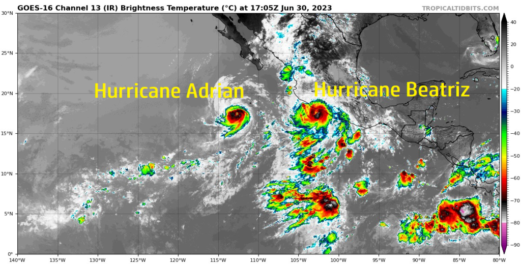
The main focus of attention largely remains in the Eastern Pacific, with hurricanes Adrian and Beatriz churning away off and along the western coast of Mexico. Adrian continues its journey westward into the open Pacific Ocean, while Beatriz will ride along and effect portions of the Mexican coast before generally tracking towards Baja California. Out in the Atlantic Ocean, things still remain quiet, with the only area of interest being a small grouping of showers and storms southeast of Bermuda. This area of low pressure will really struggle to organize, if at all, over the coming days due to the largely unfavorable upper-air wind pattern in place.
Current Tropical Conditions
Beginning with Hurricane Adrian here in the Eastern Pacific, as of 10am Friday the 30th, Adrian is a Category 2 hurricane, with sustained winds of 105 mph, located south of Baja California moving northwest at 7 mph. Current forecasts have Adrian weakening to a tropical storm by Saturday evening, before further weaking to a depression by Sunday. This is mainly due to it running into more unfavorable wind shear aloft and much drier air. This storm is not expected to impact any major landforms and looks to remain over open waters for the rest of its life.

Next, we got Hurricane Beatriz. Breatriz is currently a Category 1 hurricane, with sustained winds of 75 mph moving northwest at 13 mph and is located along the southwestern Mexican coastline. Unlike Adrian, Beatriz will pose a more significant threat to life and property as it moves along the coast. A Hurricane Warning is in effect for the coastal areas of Guerrero, Jalisco, Michoacan, and Colima. Along with hurricane-force winds, wave heights of 5 to 10 feet will impact the coastline and heavy rainfall up to 5 inches in places will impact portions of southern and western Mexico. These heavy rains will cause issues and pose a substantial flooding risk, as well as mudslides. Beatriz will gradually weaken as it approaches Baja California by early next week before fizzling out mid next week.


Over in the Atlantic, the same story over the last few days keeps continuing on over the coming days. Conditions out here remain very unfavorable for tropical development, mainly due to the increased upper-level wind shear over the basin. The only area of interest in this area is a group of thunderstorms located southeast of Bermuda, but tropical development is not expected from these storms, due to the aforementioned hostile wind shear in place.
Extended Outlook
Over the next week or two, the main area for tropical activity looks to be along the western coast of Central America. Discrepancies between the EPS and GEFS ensembles are noted, with the GEFS more bullish on tropical activity than the EPS, however, this region would be the most favorable due to the reduced upper-level wind shear and very warm SSTs. In the Atlantic, things are a little more consistent in the long-term, with neither ensembles picking up on strong signals for organized activity. A vigorous subtropical jet over much of the Atlantic will help make things extremely difficult for any fledgling surface lows coming off the West African coast to get its act together and traverse the Atlantic.
Conclusion
The main stories over the next few days will be the progression of Hurricanes Adrian and Beatriz in the Eastern Pacific. Adrian looks to remain over open waters, while Beatriz will pose a more significant threat to life and property as it straddles along the western Mexican coast through early next week. Over the next couple weeks, more attention will have to be brought along this same area, as this region will be the most favorable for tropical development long-term. For the Atlantic, the only area of interest off of Bermuda will not look to organize due to the unfavorable air patterns in place. This same trend looks to be the mainstay over the next couple weeks, which will help keep this basin quiet for the most part.


