
I promised you guys I wouldn’t write one of these unless it was necessary. And here I am.
Hurricane Eta is strengthening and organizing as it moves toward the coast of Nicaragua today and is set to make landfall by Tuesday. It is forecast to do so as a Major Hurricane. At which point it will move inland, turn north and end up back out over water again in the northwest Caribbean. And then – stop me if you’ve heard this one before – there is a chance it gets into the Gulf of MExico or off the east coast of Florida.
News no one wants to hear. Especially in November.
From the NHC

SUMMARY OF 1000 AM EST
LOCATION…14.8N 81.5W
ABOUT 115 MI…185 KM E OF CABO GRACIAS A DIOS ON NIC/HON BORDER
ABOUT 140 MI…225 KM ENE OF PUERTO CABEZAS NICARAGUA
MAXIMUM SUSTAINED WINDS…110 MPH…175 KM/H
PRESENT MOVEMENT…W OR 265 DEGREES AT 9 MPH…15 KM/H
MINIMUM CENTRAL PRESSURE…962 MB…28.41 INCHES
FORECAST POSITIONS AND MAX WINDS
INIT 02/1500Z 14.8N 81.5W 95 KT 110 MPH
12H 03/0000Z 14.4N 82.4W 115 KT 130 MPH
24H 03/1200Z 14.0N 83.1W 120 KT 140 MPH
36H 04/0000Z 13.9N 83.6W 90 KT 105 MPH…INLAND
48H 04/1200Z 13.9N 84.5W 45 KT 50 MPH…INLAND
60H 05/0000Z 14.2N 85.7W 30 KT 35 MPH…INLAND
72H 05/1200Z 14.6N 87.0W 25 KT 30 MPH…INLAND
96H 06/1200Z 15.8N 87.7W 25 KT 30 MPH…INLAND
120H 07/1200Z 17.5N 86.5W 30 KT 35 MPH…OVER WATER
TECHNICAL DISCUSSION
Eta has become an impressive November hurricane as it continues to undergo rapid strengthening. Visible and infrared satellite imagery reveals a very symmetric Central Dense Overcast with cloud top temperatures below -80C. A warm spot has recently become apparent in infrared imagery while a small eye has been seen microwave imagery and recent visible satellite data. An Air Force Reserve Hurricane Hunter aircraft that completed two center penetrations into Eta this morning reported a minimum pressure of around 972 mb, and flight-level and SFMR winds that supported an intensity of around 85 kt. The plane also reported a 12 n-mi-wide eye on its second pass through the center. With the continued improvement in organization since the plane departed, the initial intensity has been increased to 95 kt, as the eye has become more apparent. Low vertical wind shear and warm sea surface temperatures ahead of Eta are expected to allow for continued rapid strengthening during the next 12 to 24 hours. The updated NHC intensity forecast is above all of the intensity aids and now calls for Eta to become a category 4 hurricane before it nears the coast of Nicaragua. After landfall, Eta should quickly weaken while it moves over the mountainous terrain of Central America.
The hurricane is moving westward or 265 degrees at 8 kt, a little slower than before. A mid-level ridge building over the south-central United States is expected to cause Eta to turn west-southwestward later today, and this motion should bring the center of the hurricane near the coast of Nicaragua within the hurricane warning area Tuesday morning. Eta is forecast to then turn westward, moving farther inland over Central America. The track guidance is tightly clustered during the first 48 hours or so, but the models generally show a slower forward motion than before, and the NHC track forecast has been adjusted accordingly. Although Eta’s low-level center may not survive after being inland over Central America for so long, most of the global models depict a cyclone over the northwestern Caribbean Sea later this week and into the weekend which appears to develop from at least a part of Eta’s remnants, and the new NHC track forecast shows the system emerging over the northwest Caribbean Sea after 96 h. However, the uncertainty in the long-range portion of the forecast remains quite high.
Since Eta likely to be a very slow-moving system after it makes landfall in Central America, torrential rains and flooding will be a major threat from Eta.
Model Data
Central America is about to get hammered with some very – very – heavy rain. As noted by the NHC, torrential rain is likely from this and potentially catastrophic flash flooding. Especially givent he topography of Nicaragua and Honduras.

Model data is showing 10- to 20-inches of rain will be possible across the two countries during the next five days. Pretty incredible totals.
Beyond that, model data does show the system getting back out into the Caribbean.

The GFS, pictured above, shows that by Friday night and into Saturday morning, a piece of Eta may survive landfall and push back out into (roughly) the same area that Zeta formed.
Other model guidance also suggests this as a possibility.

The question becomes, ‘how much of Eta will be left?’ At this point, that is a bit of an unknown. Most model guidance shows the system spending between 48 and 72 hours of land. That usually doesn’t bode well for tropical systems.
Intensity guidance shows that restrengthening may be possible.
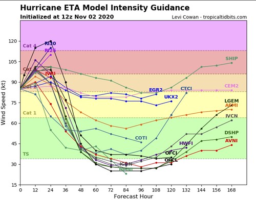
Now you guys know me, I often say, “don’t look beyond 72 hours for intensity specifics” but in this case, we aren’t look at specifics, we are just looking to see if any model data shows restrengthening. And it does.
What about after that point?
We don’t know yet. It will depend on the trajectory of the cold fronts passing through the area and how the ridges of high pressure settle in behind said cold fronts.

As you can see from the very sophisticated graphic above (as always, thanks to Pivotal Weather for letting me doodle on top of their maps), the further south and into the Gulf of Mexico that the next handful of fronts decide to go, the better the chance that Eta will be blocked, and taken out to sea.
But the further east and northeast the cold fronts decide to go, and the further east and northeast the ridges of high pressure decide to settle, the more likely that Eta, then, becomes a problem for the Gulf of Mexico.
The Bottom Line
There is still a lot we don’t know. But what we do know is that there is an increasing likelihood that some part of Eta survives landfall and ends up back into the Caribbean where restrengthening and reorganization looks possible.
If that happens, the next step will be to watch the trajectories of cold fronts and ridges moving through the southeast.


