I have one final project to submit here on the blog. I had to choose another local severe weather occurrence and explain the event while reviewing what happened and the data that was collected. Rather than look at one of the more widely known storms to impact the coast, I chose to look at an equally large hurricane that crossed to the east of Mississippi but also impacted much of the southeastern region.
Life Cycle
Hurricane Ivan, like many other hurricanes to enter the Gulf Coast was spawned from the African coast as a result of a tropical wave and made itself known as the 9th tropical depression of the 2004 year on the 2nd of September. As it moved across the Carribbean, Ivan held a Category 5 rating, which weakened and then regained it’s Category 5 status, as it headed through Cuba. By the time it reached the coastline of the United States in Gulf Shores, Alabama, it was still strong at a Category 3. With this paper, I hope to shed some light on the unique case that was Hurricane Ivan.
Hurricane Season in the Atlantic goes from June 1st through November 30th. The traditional “peak” of hurricane season in the south lasts from the middle of August until the end of September. While many hurricanes may develop, at varying category ratings on the Saffir-Simpson Scale, the path of the storm can be quite unique and often rather intricate.
Let’s take a look at the data behind the storm and examine the formation along the way; the formation of Ivan on the 2nd of September, 2004 and it lasted until the 25th of September, 2004. Like all other great hurricanes, Ivan began as a tropical cyclone on the 3rd of September and within two days Ivan had already reached a Category 3 rating with winds at 125 mph. According to the National Hurricane Center, the rapid development of the storm was so unforeseen and raised much concern considering the low-latitude within the Atlantic.
As Ivan entered the Caribbean islands, he reached the Category 5 level with winds at 160 mph and upon hitting the stray islands, Ivan would weaken and then regain the momentum as Category 5. The maximum wind speed was reached on the 11th of September and the greatest strength was met at 910 millibars on the 12th of September. Upon approaching the southern coast of the United States, Ivan weakened to a Category 4 with its trajectory pointed directly toward Alabama.

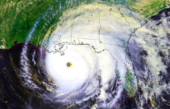
As shown by the image, the strength of Ivan fluctuated rather quickly and the path of the storm was directly toward the northwest and then took a northern drive before curving toward the northeast as a weak remnant of the tropical storm. The final passage of the storms life consisted of curving from the northeast down south to the tip of Florida before curving northwest again and gaining more power on its final days of its lifespan.
The central eye of Hurricane Ivan seemingly weakened and the bottom left quadrant was lost as he drove toward the Alabama coastline. Within the same day, while still residing over Alabama, Ivan turned back into a tropical depression that was losing strength as it moved into Virginia on the 18th of September. Remnants persisted through the northeast and eventually ended in Texas on the 25th of September. The destruction and severe weather that was brought about due to Ivan was rather substantial.
In many of the Caribbean Islands, 10″ of rain were seen which led to numerous mud slides and freshwater flooding. According to NOAA’s report on Ivan, “some peak rainfall totals are 16.20 from Tobago . . . a few of the largest rainfall totals were 28.37 in,” (4). Along with this, there were 117 tornadoes to outbreak in states including Virginia, Georgia, Florida, Pennsylvania, Alabama, South Carolina, Maryland, North Carolina, and West Virginia. As if those weren’t enough for the people along the path of the storm, a storm surge between 10 and 15 ft hit along the Destin coast of Florida, heading toward Mobile, AL. Hurricane Ivan destroyed millions of cubic feet of forests and timber as well as halting or disrupting the offshore oil operations of various platforms. Many pipelines were heavily destroyed and 7 platforms were completely destroyed.
Forecasting
The forecast leading up to the event was given very detailed critique by the National Hurricane Center in the Tropical Cyclone Report by Stacy R. Stewart. According to the report, the track errors for the 12, 24, 36, 48, 72, 96, and 120 hr forecasts was incorrect in nautical miles by 24, 47, 79, 108, 161, 222, and 289. With each new forecast, the prediction of nautical mile placement was more significant. When looking at intensity errors, the greatest error was found at 96 and 120 hours as a result of the rapid growth of the hurricane. Warnings for the Gulf Coast were issued at about 51 hours before Ivan made landfall and in the 72 hour period before the first landfall, only 95 miles were between the westernmost and easternmost prediction tracks.
Impacts
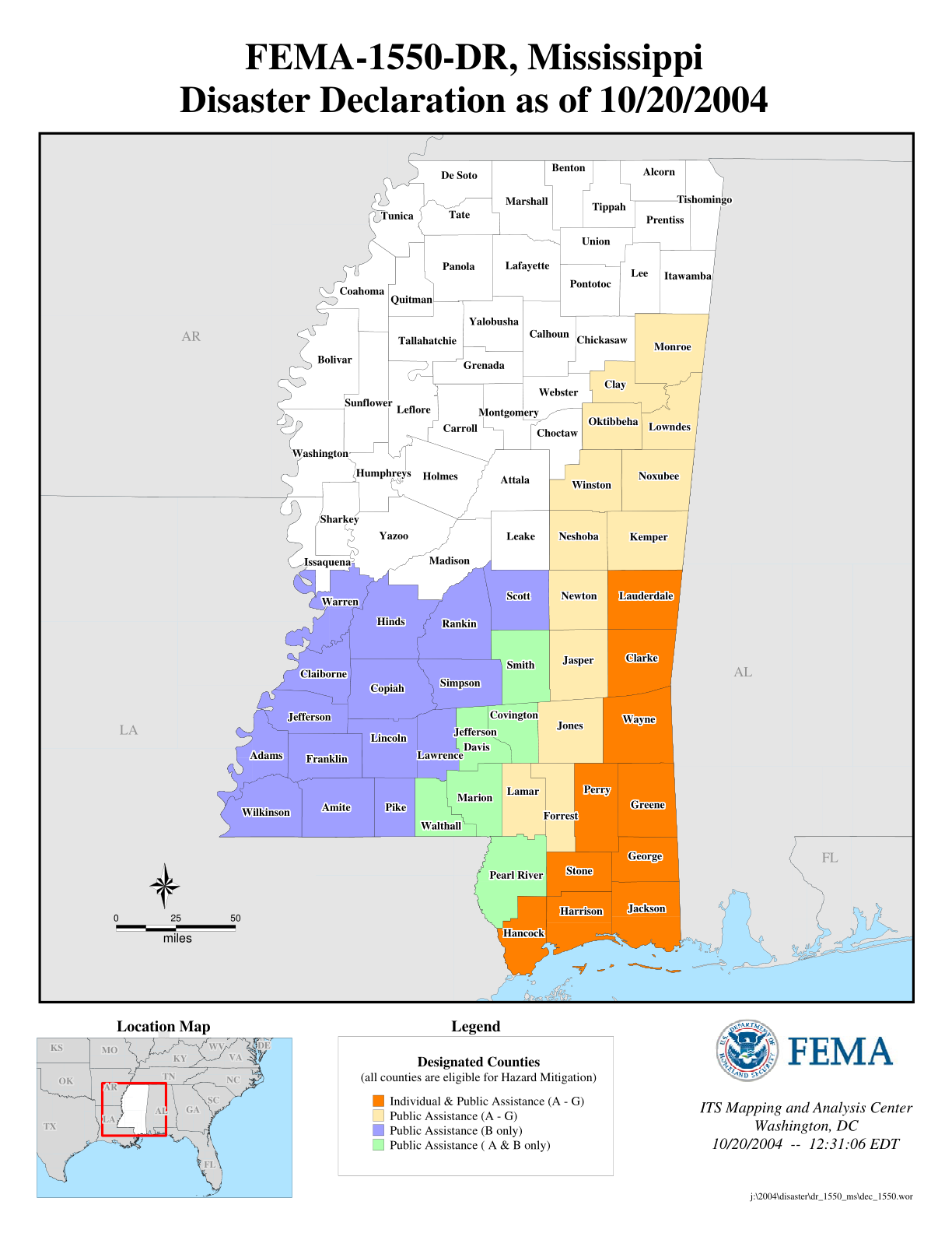
While Hurricane Ivan never directly landed over Mississippi, a fair amount of water and damage was still able to be seen. In the graphic below, Homeland Security’s FEMA released the disaster declaration that was released in October of 2004 indicated that several counties across the state required aid in disaster relief.
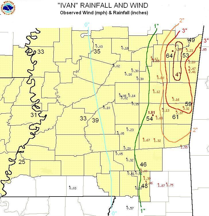
In addition to those reports, the National Weather Service out of Jackson, MS mentions numerous accounts of tree damage in Lauderdale County that were caused by strong northern winds out of the backside of Ivan. We’re also given reports that the heavy rain reached as far south as Meridian and over 4″ fell in what’s referred to as the “Golden Triangle”. Below is a chart showing the rain and wind that was observed in relation to Ivan’s passing in Alabama. Notice how even though Ivan never directly crossed into Mississippi, the impacts of the winds and rain were still felt in a large portion of the state.
Notes
According to hurricanescience.org we find some interesting facts about Hurricane Ivan;
- “hurricane Ivan’s journey was more than 9010 km (5600 mi) long and it existed for over 22 days.”
- “Ivan had the world record of 33 six-hour periods with an intensity at or above Category 4 strength.”
- “Hurrican Ivan became the southernmost storm on record, at 10.2 N, to reach major hurricane status.”
- “This hurricane was the third of four hurricanes to impact Florida within a six-week period during the highly active 2004 hurricane season.”
- “. . . the maximum confirmed wave height within the hurricane’s eyewall was 27.7 m (91 ft).”
- “Upon comparing this to the wave action detected as the hurricane assed over 6 tide gauges deployed by the Naval Research Laboratory at Stennis Space Center, MS.”
- “It is rare for hurricanes, such as Ivan, that are named east of longitude 35 W, to make landfall on the U.S. mainland, only four others, hurricanes Donna (1960), Hugo (1989), Georges (1998), and Isabel (2003) have done so since record keeping began.”
- “Some debris piles in Alabama grew to be 21 meters (70 feet) tall and 1.2 kilometers (three-quarters of a mile) wide during the Hurricane Ivan cleanup.”
Additionally, upon seeing Hurricane Ivan make a direct line for the Gulf Coast, many of the planes from major Air Force bases were required to evacuate aircraft to more northern base installations. The planes varied from C-130s to F-16s, and even some some A-10s. Bases across the southern coast ranging from Florida to Louisiana were evacuated and the most southern alternative base used as a staging facility was Little Rock Air Force Base in Arkansas.
After looking at Hurricane Ivan in its entirety, it can be concluded that Ivan was a very significant hurricane that, despite only making landfall at a Category 3 rather than a Category 5 like it had been in earlier stages of its life, it still caused a great deal of destruction and left many people in harm. I outlined the hurricane’s path, the lifespan of the hurricane some records that were set, destruction that resulted from Ivan, and more local impact. While Hurricane Ivan isn’t known for being the worst or the biggest, each hurricane is unique in its own formation.
The name Ivan was finally retired in 2005 and was later replaced with Igor for the 2010 hurricane season. While we don’t see many hurricanes in modern days being compared to Hurricane Ivan, we still see how by looking at the unique and flexible formation of Ivan, could lead to modern meteorologists being more decisive in the forecasts for hurricanes. Due to unique cases, hurricanes will continue to challenge the known and often stereotypical checklist for predictions.
I have thoroughly enjoyed researching this hurricane because it gave me a chance to take a look at another storm that challenged the normal and created a challenge for meteorologists. It’s storms like these that keeps meteorologists guessing as to where, when, and how bad each hurricane will bring. With each storm, the weather world attempts to get quicker and better with each forecast. Therefore, as every new hurricane season comes and goes, meteorologists will adapt and take what each new storm brings into consideration when looking at others to follow. As years go on technology will adapt and equations will get more thorough.
Works Cited:
“2004- Hurricane Ivan.” Hurricanes: Science and Society: Home, www.hurricanescience.org/history/storms/2000s/hurricaneivan/.
“Base People, Aircraft Move from Hurricane Ivan’s Path.” U.S. Air Force, 15 Sept. 2004, www.af.mil/News/Article-Display/Article/136067/base-people-aircraft-move-from-hurricane-ivans-path/.
“Hurricane Ivan Information, Photos, Gulf Shores, Orange Beach, Perdido Key Alabama AL, Ala, FL, Fla.” Gulf Shores Alabama, www.gulf-shores-alabama.net/hurricane-ivan.html.
“Hurricanes in History.” Glossary of NHC Terms, www.nhc.noaa.gov/outreach/history/#ivan.
“Mississippi Hurricane Ivan (DR-1550).” What Is Disaster Assistance? | FEMA.gov, www.fema.gov/disaster/1550.
Stewart, Stacy R. “Tropical Cyclone Report.” Hurricane Ivan, 16 Dec. 2004, pp. 1–44., www.nhc.noaa.gov/data/tcr/AL092004_Ivan.pdf.
US Department of Commerce, and NOAA. “NWS Jackson Hurricane Ivan Summary Page.” National Weather Service, NOAA’s National Weather Service, 28 June 2017, www.weather.gov/jan/2004_hurricane_ivan_summary_page.


