It is a good news, bad news situation. The good news is that Invest 92L is taking “longer” to get developed and organized. Originally in the 2-to-5 day window, Day Five would’ve been today.
And while there is still time for it to develop a low-level center of low pressure, the likelihood is on the lower end of the scale. Not zero, but lower.
The bad news is that the length of time it takes to develop makes very little – if any – difference to the storm and the potential impacts to land in the future.
Invest 92L
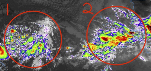
That is a look at both of the recent waves to come off of the African coast. Wave No. 1 is Invest 92L. Wave No. 2 is not designated yet. And may never be, but bares watching.
Based on the GEFS model data, Invest 92L has a 100-percent chance of development while the wave behind it is looking at a zero-percent chance.

We’ll see.
From the NHC
The National Hurricane Center continues to monitor Invest 92L. Here is the latest from them:
Tropical Weather Outlook
NWS National Hurricane Center Miami FL
800 AM EDT Mon Jul 27 2020For the North Atlantic…Caribbean Sea and the Gulf of Mexico:
The Weather Prediction Center has issued the last advisory on the remnants of Hanna, located inland over northern Mexico.
1. Shower activity associated with a broad area of low pressure located a little more than 1000 miles east of the Windward Islands has become a little less organized since last night. However, environmental conditions are still expected to become more favorable for development in a day or two and a tropical depression or tropical storm will likely form within the next couple of days. The system is forecast to move westward to west-northwestward at 15 to 20 mph and could begin to affect portions of the Lesser Antilles on Wednesday or Wednesday night. Interests on those islands should continue to monitor the progress of this system.
* Formation chance through 48 hours…high…80 percent.
* Formation chance through 5 days…high…90 percent.
So, the NHC is pretty confident this will be aTropical Depression or Tropical Storm during the next two days.
Model Data
As for Invest 92L, the latest model trends are not as favorable for hurricane development as they were a few days ago.
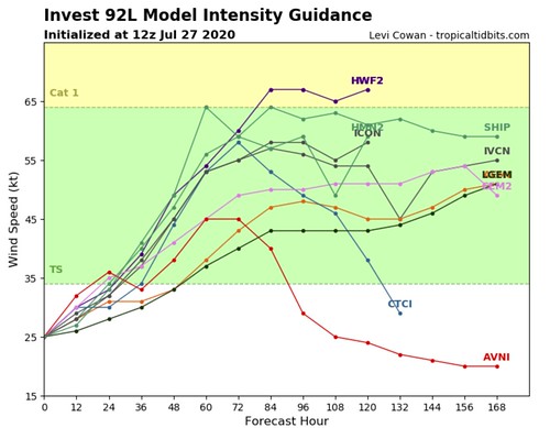
This shows that model intensity model guidance shows that Invest 92L will only attain Tropical Storm strength. Even the SHIPS model is showing the chance of “Rapid Intensification” isn’t very high at all.

So where is it going? Great question. Right now, most model guidance takes it toward the Bahamas. But there is some variability about just how close to the Bahamas this thing gets.
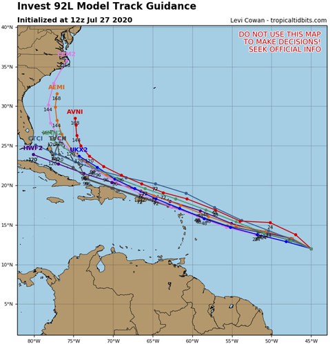
The spread between all of the model guidance is a bit wider than the models shown above. There is some data that shows a chance that it is south of Cuba. And other data to support that it is further out to sea, east of the Bahamas by this next weekend.
For example, the European Ensembles show Invest 92L may be as far southwest as near the Yucatan.
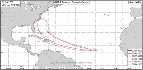
While the GEFS Ensembles show that Invest 92L may be off the coast of the Carolinas at the same time.
Yeah, but which one is right, Nick?
No idea. Truly, neither of these are probably accurate.
Then why show them if you don’t think they are accurate?
It is the only available data we have. And in the model failure, we can still learn something to help us make a more accurate prediction.
In this case, the difference between the two models is actually the difference between a big ridge of high pressure in the Atlantic. One model, the GEFS Ensembles, thinks the ridge will be a bit weaker, and Invest 92L will be able to curve to the north quicker. While the Euro Ensembles thinks the ridge will be a bit more stout and hold Invest 92L on a more westerly track.
Meaning a bit like Dorian and Irma from previous seasons, watching how the ridge of high pressure evolves in the Atlantic in the coming days will be just as important as how well Invest 92L organizes.
The Bottom Line
Invest 92L is still out in “Curiosity Land” in terms of United States impacts. We are still not 100-percent certain where it may go, how it may develop, and what it may mean for anyone.
Could this get into the Gulf? Yes
Could this stay out to sea? Yes.
Could this be a Major Hurricane? Yes.
Could this never develop? Yes.
There are still many variables.
For now, though, double check that Hurricane Preparedness Kit, make sure you’ve got what you need – particularly during the pandemic. And keep tabes ont eh forecast.


