The National Hurricane Center is tracking three different areas for potential tropical development. The closest to the United States is Invest 95L
Cu rent model guidance suggests that Invest 95L will drift into the Gulf of Mexico in coming days and that the chances for development – in the available model data, not the official forecast – are between 50- and 90-percent.
Two of those models, the ECMWF Ensemble and GFS Ensemble, have the chance for development even higher at 80- and 90-percent, respectively. This was ponted out on Twitter by Michael Ventrice.
Models are locking onto a tropical risk for Florida & Gulf states in the short-term. If this tropical disturbance undergoes genesis, it is anticipated that it will stay on the weaker spectrum.
Genesis risk:
Cal. ECMWF EPS: 80%
Cal. GEFS: 90%
Official NHC: 60% pic.twitter.com/kIE06x33sa— Michael Ventrice (@MJVentrice) September 11, 2019
The model data
Now that the NHC has classified Invest 95L, the model data can run on it. Keep in mind that because there is no closed low and organized area o flow pressure for the models to ‘pick up on’ that the models will have a difficult time projecting the eventual specific path and eventual intensity of the system.
But, as of now, the model data isn’t terribly alarming at this point.
Looking at the timeline from the GEFS, it looks like it will be somewhere along of near the northern Gulf Coast in about five days.
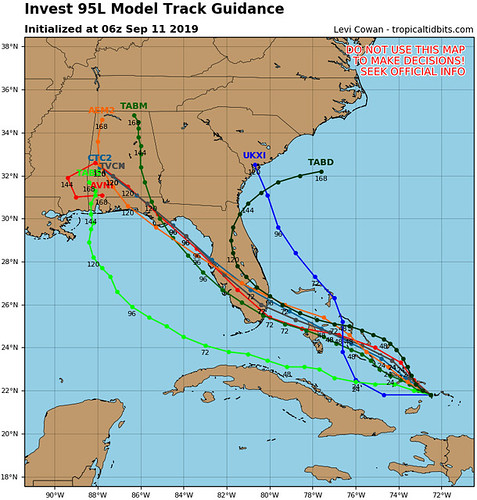
The track guidance lines up with where the NHC is watching for development. So this isn’t too surprising. Model guidance for intensity is likely going to change, but for now, it keeps Invest 95L as a tropical depression or tropical storm.
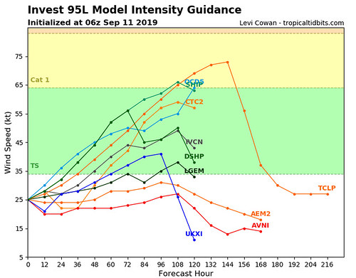
I know some of you might be saying, ‘well wait just a second, wasn’t Dorian just supposed to be a Trocial storm, too?’
Yes! At this point in Dorian’s life cycle, the models only had it as a tropical storm. But that doesn’t mean that this will be a Category Five.
Every storm is different. Don’t rely on a past storm to inform you about a current storm.
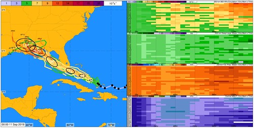
A wider view of the ECMWGF Ensemble data shows that both Invest 95L and Invest 94L (back east in the open Atlantic) show signs for development.
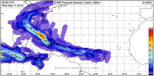
The ramp-up of “percent chance of development” between the models and the official forecast for Invest 95L during the last 36 hours hasn’t been very rapid, but it has been steady.
From the NHC
Tropical Weather Outlook…Corrected
NWS National Hurricane Center Miami FL
800 AM EDT Wed Sep 11 2019
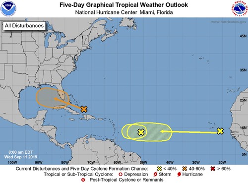
For the North Atlantic…Caribbean Sea and the Gulf of Mexico:
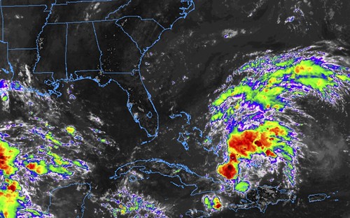
1. Widespread cloudiness and showers extending from the southeastern Bahamas northward over the southwestern Atlantic for a few hundred miles are associated with a surface trough of low pressure. Limited development of this system is anticipated today or tomorrow, however conditions are forecast to become a little more favorable for development over the weekend, and a tropical depression could form as the disturbance moves slowly toward the west-northwest across the Florida Straits or South Florida and over the eastern Gulf of Mexico. Regardless of development, this disturbance could produce periods of locally heavy rainfall and
gusty winds across the Bahamas through Thursday, and across Florida during the weekend.
* Formation chance through 48 hours…low…20 percent.
* Formation chance through 5 days…medium…60 percent.
2. A broad low pressure system, associated with a tropical wave, is located about 650 miles east of the Lesser Antilles. This disturbance is accompanied by a large but disorganized area of cloudiness and thunderstorms. This system is forecast to move westward toward unfavorable upper-level winds for tropical cyclone formation.
* Formation chance through 48 hours…low…10 percent.
* Formation chance through 5 days…low…10 percent.
3. A tropical wave located between the west coast of Africa and the Cabo Verde Islands is forecast to move quickly westward during the next several days. Some slow development is possible over the weekend or early next week when the system is moving over the tropical Atlantic.
* Formation chance through 48 hours…low…near 0 percent.
* Formation chance through 5 days…low…20 percent.
What should you do for now?
Keep tabs on the forecast in the coming days. Check your Hurricane Preparedness Kit. That’s about it. Make sure you have enough supplies to last a few days without power and water.
Not because this system is anticipated to wipe out power and water to an area, but rather, you should always have enough supplies to last a few days without power and water during Hurricane season.


