Now that we are getting to be about 72-96 hours out, data is starting to come into better agreement about the timeline and threats for the severe weather threat on New Year’s Eve for the Gulf Coast.
That said, there is still a fair amount of uncertainty about specifics.
I know a lot of you wonder – and a few of you ask – “will it tornado at my house or not?” but that isn’t how weather forecasting works this far out.
We try our best to give as much information as soon as we can, but we also have to balance our desire to offer information with whether or not the data we are using is accurate and trustworthy. So it is a balancing act and we do the best we can to manage it.
From the SPC
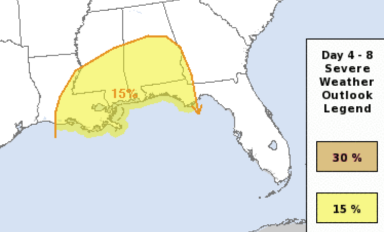
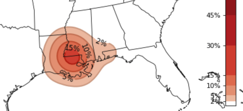
Right now, for the Gulf Coast, the Storm Prediction Center has highlighted part of Louisiana, Mississippi, Alabama and Florida – and even a sliver of georgia) with a Slight Risk for severe weather.
As a big system swings through the area it will open the door for showers and storms to develop Thursday afternoon through Friday morning on the western side of the Risk Area and from Friday morning and into the afternoon on the eastern side of the Risk Area.
The SPC Discussion:
…Thursday/Day 4 and Friday/Day 5…
An upper-level low is forecast to move northeastward across the southern Plains on Thursday as an associated cold front advances eastward into the lower Mississippi Valley. Moisture advection appears likely to continue ahead of the front across the central Gulf Coast states where surface dewpoints should be in the 60s F. Thunderstorms may develop during the day along the front with additional convection forming further east across the moist sector.
Model forecasts suggest that a low-level jet will increase in strength, moving north-northeastward across Alabama during the late afternoon. Convective development may be favored on the nose of the low-level jet during the late afternoon and early evening. Additional storms may develop further to the west across the lower Mississippi Valley. Low-level and deep-layer shear profiles should be favorable for severe storms across those two areas.
The main threats would be for tornadoes and wind damage.
At this point, there is some uncertainty concerning how far the quality moisture can advect northward. For this outlook, have drawn the 15 percent contour across central Alabama, where there appears to be a good chance surface dewpoints will reach the lower to mid 60s F.
On Friday, the upper-level low is forecast to move north-northeastward into the mid Mississippi Valley as southwest mid-level flow remains entrenched across the eastern Seaboard. Thunderstorm development will be possible along and ahead of a cold front as a low-level jet moves northward across the Carolinas.
Low-level and deep-layer shear profiles are forecast to be favorable for severe storms with the main threats being tornado and wind damage. Have placed the 15 percent contour in the area where the chance for quality moisture and convective potential is maximized, according the latest ECMWF solution.
SPC.Noaa.gov
And when the SPC says the main threats are “tornadoes and wind damage” in a Day 4 discussion, it usually means the potential for more than just one or two tornadoes will exist.
Karrie Meter and CIPS Analogs
The Karrie Meter and the CIPS Analogs have become very useful tools to use for severe weather events along the Gulf Coast.
For those who aren’t familiar with the Karrie Meter and the CIPS Analogs, you can find more info on the Karrie Meter here. And find more info on the CIPS Analogs here.
For this event, it looks like the numbers on the Karrie Meter are being held in check by the lack of instability being shown within the model guidance.
So while the numbers may look “low” right now, I tend to think that may change.
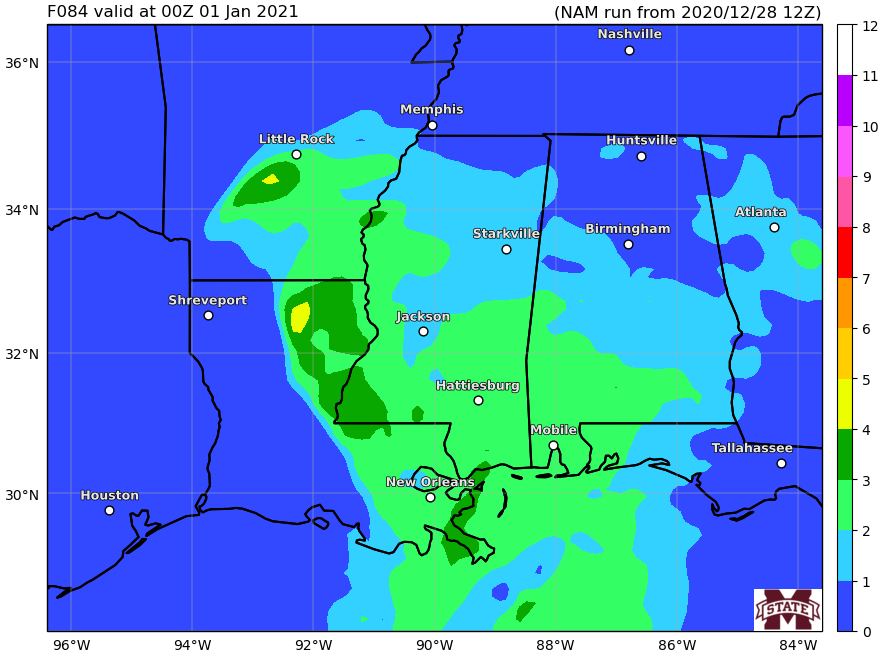
Above is a look at the Karrie Meter for Thursday afternoon / evening across parts of Louisiana, Mississippi and Alabama. Notice the numbers coming back from the NAM show a 2-to-3 range at this point.
But when you look at the hard data and massage out some of the specifics that the model can’t resolve well at this distance in time, you get a much higher number.
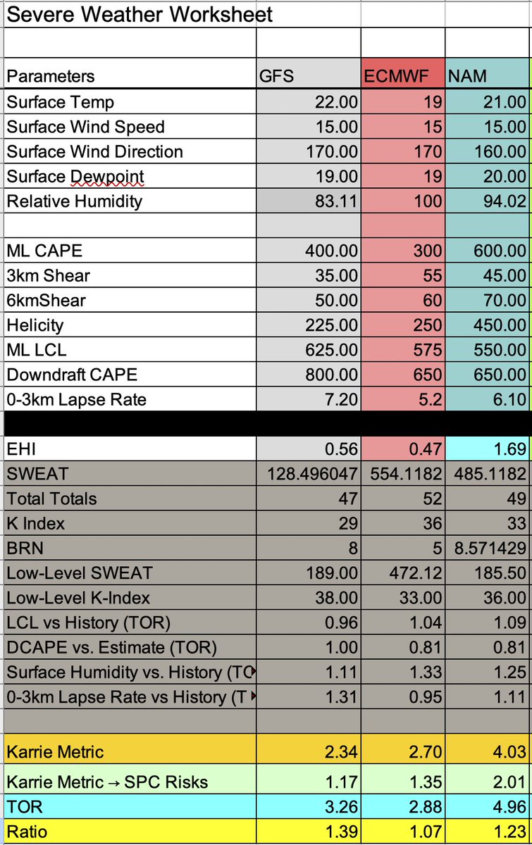
That is a look at the Karrie Meter across the GFS, ECMWF and the NAM. It shows an average of about 3.02 – which converts back to a Marginal-to-Slight Risk for the area. But the KM-to-TOR ratio in yellow shows numbers greater than one.
Since I’ve had that “TOR” equation I’ve tracked that, on average, it comes out to about a 0.80. And that is the average across about two years of data.
But when it gets above a 1.00, the area is more likely to see a tornado. In fact, there has only been one situation where there hasn’t been a tornado in the area when that number is greater than one. So, for the next few days, I will be watching that number closely.
And do know, the number will bubble up and down in the coming days. Some days it may be below 0.75 and others it may be above 1.50! We will jsut have to see how things shake out.
The CIPS Analogs are also showing the potential for tornadoes in the region.
The short-term analogs weren’t available, but these GEFS numbers are just as useful. Note the bullseye across SW Mississippi and into the toes of the boot of Louisiana. A good way to visualize a 15-percent tornado risk is that it is the data suggesting that, historically, situations like this produce an environment where you are 15-times more likely to see a tornado on this day, than any other regular day.
These numbers, like the Karrie Meter numbers, will flop back and forth in intensity and location in the coming days, but it will need to continue to be monitored closely.
The Bottom Line
Truly the bottom line is that there is the potential for severe weather on Thursday (New Year’s Eve) and Friday (New Year’s Day) across the Gulf Coast. The timeline is for this event from start-to-finish may last from late Wednesday night / early Thursday morning through Friday night.
However, the severe weather risk is currently from Thursday morning through Friday morning. And the peak intensity is looking like Thursday afternoon through Friday morning early.
The concern is or heavy rain, localized flooding, wind gusts up to 70mph, hail up to the size of quarters, and the potential for a few tornadoes. today, some of the data is starting to suggest a strong or long-track tornado may be possible, too.
or now, double-check the batteries in your NOAA Weather Radio, make sure you have a good weather app downloaded to your phone, make sure your WEA alerts are turned on, and go over your severe weather plan.
I will continue to post updates as we get closer!


