Anecdotally, I was chatting with Karrie the other day at the anchor desk and I mentioned that it “felt like” January 21st was – historically – an active weather day for the Pine Belt.
I cited a few days recently (including the Hattiesburg EF-3 from 2017 and the second-coldest day on record, set back in 1983. Both on January 21st.
But it got me thinking, “Is January 21st really an active day?” or does it just feel like it?
So I went digging through the climate records. I extended my time frame for “active weather” to include January 20th and January 22nd. Just in case events happened overnight into the 21st or late at night on the 21st and into the 22nd.
I was not disappointed.
Behold: Recent History!
If it seems like hearing January 21st brings on weather anxiety, it is for good reason. Since 2010, severe weather occurred around – or very near – the Pine Belt in five of the past 10 years. So, half the time during the past decade, if you’ve looked at the calendar and noted “January 21st,” there was a chance for severe weather in the area or nearby.
In 2018, there wwere two tornadoes early on January 22nd – one in Covington county and another in Jones County. In 2017, we all remember the EF-3 that went through Hattiesburg. In 2016 there was a tornado on the 21st that went through Improve and Sumrall.
Back in 2012, severe weather missed us by a few counties, just to the northwest near Jackson.
In 2010, there was hail damage from a storm in Sumrall.
And that is just in the last 10 years.
Behold: More History!
Looking back further, it gets even more interesting!
In 1993, on the 21st, it rained 6.13″ at the official rain gauge for the Pine Belt. But other places picked up between 4″ and 10″ of rain.
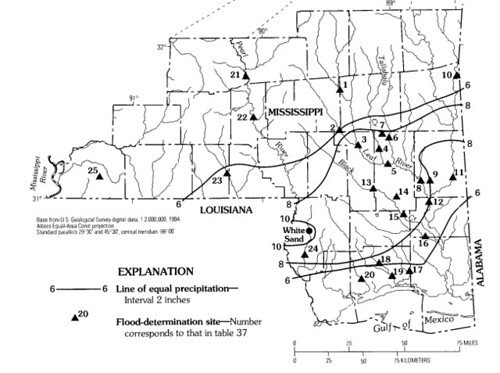
The USGS said, “The most severe flooding occurred on West Hobolochitto Creek (site 24) where the flood was the largest on record and was estimated to have a 200-year recurrence interval.”
This was the first big flood of the year along / near the Mississippi river. Later that summer, the Great Flood of 93 would occur farther north in the Midwest. It, to this day, is one of the largest floods in the history of the Mississippi River.
But let’s go back further. In 1985, on the 21st and 22nd we set a record for the coldest and second coldest overnight lows on record. It was 4F and 7F on each night, respectively.
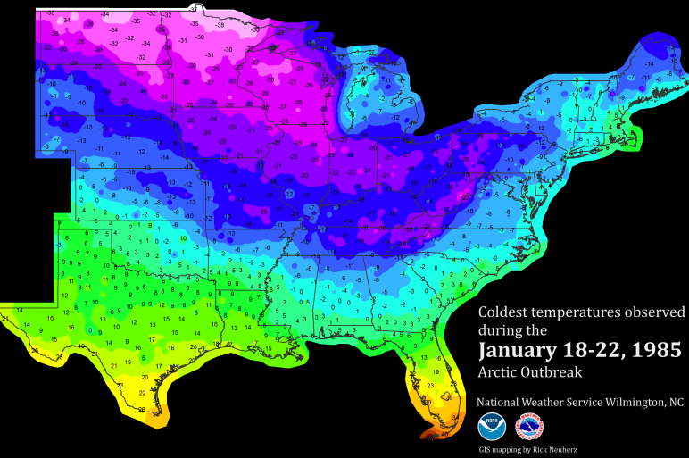
It was the “Freeze of the Century” in Florida. And was blamed for two deaths in Mississippi.
Behold: Even More History!
Even further back? Well in 1978 the area picked up 0.2″ of snow on the 20th. And in 1940 the Pine Belt received 1.5″ of snow on the 22nd.
The means two of the 12 recorded measurable snowfall events in South Mississippi occurred within the January 20th to 22nd time frame.
That means looking back in history, if you’re looking for snow… there is 16.67% chance it was between January 20th and the 22nd.
Unreal!
So it turns out that January 21st – as well as the 20th and 22nd – are an active time period for weather in South Mississippi. Recently with severe weather, and historically for record-breaking events.
Kind of wild!


