Hurricane Laura is now a cAtegory 3 Hurricane. According to the Saffir-Simpson scale, “Devastating damage will occur: Well-built framed homes may incur major damage or removal of roof decking and gable ends. Many trees will be snapped or uprooted, blocking numerous roads. Electricity and water will be unavailable for several days to weeks after the storm passes.”

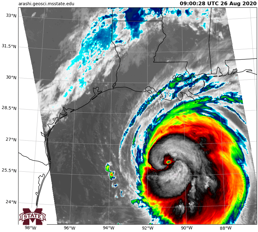
Here is a look at the infrared imagery from Dakota Smith:
A look at the 8hr evolution of the beast that is Hurricane Laura. pic.twitter.com/sZrtxeWwhR
— Dakota Smith (@weatherdak) August 26, 2020
Check out these cool loops from Dr. Kim Wood at Mississippi State University:
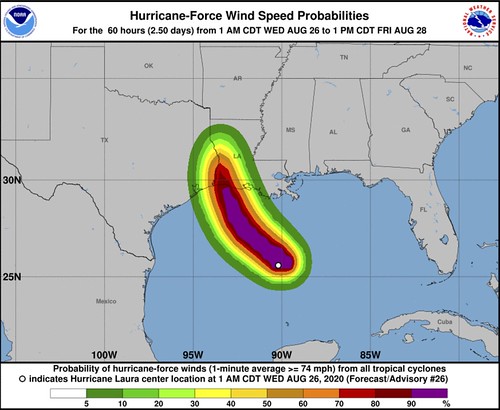
Forecast Track
Looking at the latest mid-level water vapor image on the College of DuPage site, gives some quick insight into why the final track for Hurricane Laura is through extreme eastern Texas and extreme western Louisiana.
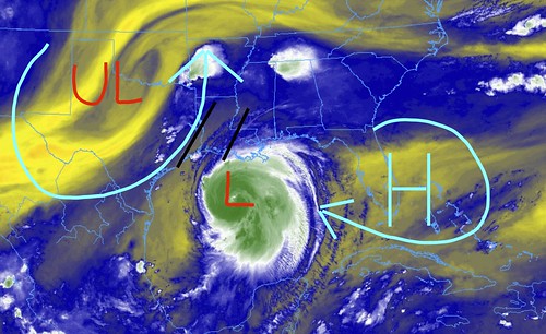
Compare this to the image from last night:
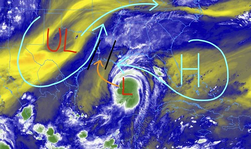
The ridge to the east continues to nudge into the Gulf and the upper-level low to the west continues to retrograde back to the west. In fact, it has slid even further back into Texas than most model guidance suggested. However the flow around that upper-low has continued to stay parked near the Texas coastline.
The alleyway north has not really changed much during the last 36 hours. Here is a look at the imagery from Monday night:

Once the Hurricane Hunters were able to fly through Laura a few times, and gain some useful data about the structure and current conditions, it was easier for the computers to model and identify all of the moving pieces. That is why the forecast track has went – roughly – unchanged during the past 48 hours.
Forecast Intensity
Laura continues to march across the Gulf through some very warm waters, in an area with very good upper level support. Recall that, a lot like our severe storms during the Winter and Spring in Mississippi, hurricanes are giant conveyor belts of heat trying to “balance the math equation” of the atmosphere. So when the waters and warm, and the upper-levels support it, hurricanes can “strengthen” very rapidly.
That is what is happening here. The Hurricane Hunters are continuing to tack readings inside of the storm. And the hurricane continues to strengthen.
Three dropsondes into the eye of #Laura over the last 2-3 hours showing a 9mb pressure fall indicative of continued rapid strengthening. 😬😮 pic.twitter.com/dAWGR8MF4V
— Dan DePodwin (@WxDepo) August 26, 2020
Right now the only thing between Laura and landfall is warm water and a continued prime environment for strengthening. Until the storm gets within about 50 miles of landfall, when the Gulf of Mexico shelf gets shallow enough to the point where there isn’t as much water beneath the surface to upwell continued warm water.
Here is a look at the sea height anomaly map:
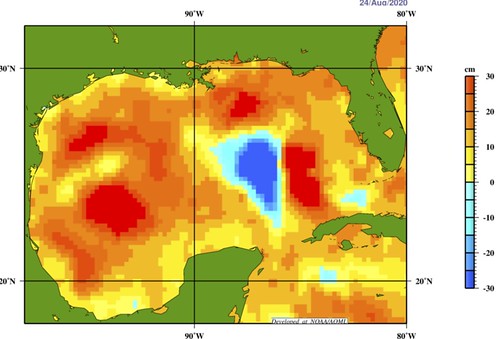
This looks at, compared to average, “how much has the water expanded?” Which may seem like a weird question to ask, but it is a good thing to calculate when trying to determine if something is warmer or cooler. Because warm things expand! And if the water expands, the sea height will be higher. So, the higher the water height, the warmer the water.
And LAura continues to track through all of the warmth.

Because of that, the forecast is for the system to make a run at becoming a Category 4 Hurricane before it start to get too close to land to continue to strengthen rapidly enough to get to a Category 5..
Latest from the NHC
At 700 AM CDT (1200 UTC), the eye of Hurricane Laura was located near latitude 26.4 North, longitude 91.4 West. Laura is moving toward the northwest near 15 mph (24 km/h) and this general motion should continue today, followed by a north-northwestward motion tonight. On the forecast track, Laura should approach the Upper Texas and southwest Louisiana coasts this evening and move inland
near those areas tonight or Thursday morning.
Data from NOAA and Air Force Hurricane Hunter aircraft indicate that maximum sustained winds have increased to near 115 mph (185 km/h) with higher gusts. Laura is a dangerous category 3 hurricane on the Saffir-Simpson Hurricane Scale, and is forecast to continue strengthening into a category 4 hurricane later today. Rapid weakening is expected after Laura makes landfall.
Laura is a large hurricane. Hurricane-force winds extend outward up to 70 miles (110 km) from the center and tropical-storm-force winds extend outward up to 175 miles (280 km). Buoy 42395, located just east of Laura’s eye, recently reported a sustained wind of 74 mph (119 km/h) and a wind gust of 107 mph (172 km/h) and a wave height of 37 feet (11 meters).
The latest minimum central pressure estimated from NOAA and Air Force reconnaissance aircraft data is 963 mb (28.44 inches).
STORM SURGE: The combination of a dangerous storm surge and the tide will cause normally dry areas near the coast to be flooded by rising waters moving inland from the shoreline. The water could reach the following heights above ground somewhere in the indicated areas if the peak surge occurs at the time of high tide…
Sea Rim State Park to Intracoastal City including Sabine Lake and Calcasieu Lake…10-15 ft
Intracoastal City to Morgan City including Vermilion Bay…8-12 ft
Port Bolivar to Sea Rim State Park…6-9 ft
Morgan City to Mouth of the Mississippi River…4-7 ft
San Luis Pass to Port Bolivar…3-5 ft
Galveston Bay…3-5 ft
Mouth of the Mississippi River to Ocean Springs including Lake
Borgne…2-4 ft
Lake Pontchartrain and Lake Maurepas…2-4 ft
Freeport to San Luis Pass…2-4 ft
The deepest water will occur along the immediate coast near and to the right of the landfall location, where the surge will be accompanied by large and destructive waves. This storm surge could penetrate up to 30 miles inland from the immediate coastline in southwestern Louisiana and far southeastern Texas.
Surge-related flooding depends on the relative timing of the surge and the tidal cycle, and can vary greatly over short distances. For information specific to your area, please see products issued by your local National Weather Service forecast office.
WIND: Hurricane conditions are expected in the hurricane warning area tonight and Thursday. Tropical storm conditions are expected to reach the coast in the hurricane warning area late today or tonight, and are expected in the tropical storm warning area tonight and Thursday.
Hurricane-force winds and damaging wind gusts are also expected to spread well inland into portions of eastern Texas and western Louisiana early Thursday.
RAINFALL: From this afternoon through Friday, Laura is expected to produce rainfall totals of 5 to 10 inches, with isolated maximum amounts of 15 inches across portions of the northwestern Gulf Coast from western Louisiana to far eastern Texas, and northward into much of Arkansas. Over the lower to middle Mississippi Valley from central Louisiana into western Tennessee and Kentucky, and southeastern Missouri, 2 to 4 inches of rainfall with isolated totals of 6 inches are expected. This rainfall will cause widespread flash and urban flooding, small streams to overflow their banks, and minor to isolated moderate river flooding.
By late Friday into Saturday, portions of the Tennessee and Ohio Valley could see 2 to 4 inches with locally higher amounts as tropical moisture from Laura moves through the region. This rainfall could lead to localized flash and urban flooding along small streams.
TORNADOES: A few tornadoes are expected this evening through tonight over Louisiana, far southeast Texas, and southwestern Mississippi. The risk for a few tornadoes should continue into Thursday across Louisiana, Arkansas, and western Mississippi.
SURF: Swells produced by Laura are affecting the U.S. Gulf coast from the west coast of Florida to Louisiana and are expected to reach the coast of Texas and northeastern Mexico today. These swells are likely to cause life-threatening surf and rip current conditions. Please consult products from your local weather office.
Specifically for South Mississippi
As Laura passes around South Mississippi, it looks like extra showers and storms will be possible as the tropical airmass is in places, and a few distant rainbands slide across the area. But the threat for constant heavy rain, high wind, and tornadoes are almost zero.
Instead occasional tropical showers and thunderstorms with brief heavy downpours and batches of gusty wind.


