Locally it looks like another hot and mostly dry day with a few renegade storms possible. I think storm coverage today may be a bit higher than yesterday. If you end up underneath one of these storms be on the lookout for some brief heavy rain, lightning, gusty wind and the potential for some small hail.
Aside from that, it will be a day with highs in the 90s. Heat index around 100F.
Same goes for tomorrow. And then we dry things out into the weekend.
[wpcode id=”41149″]
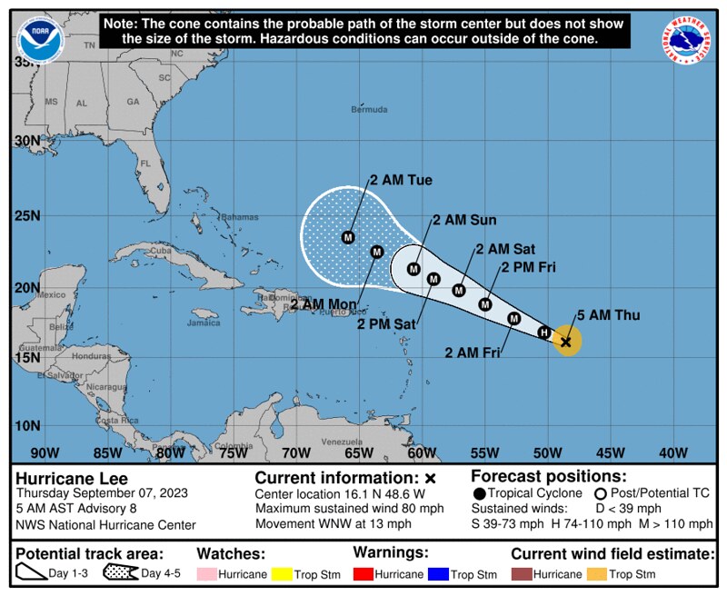
HURRICANE LEE UPDATE
Hurricane Lee has a shot to become one of the strongest hurricanes we’ve seen during the last few years. Currently it is forecast to become a Major Hurricane in the open Atlantic.
There has been a lot of talk on the ol’ interwebs and the social medias about Lee’s track in the coming days. There are countless non-meteorologists hiding behind cell phone cameras and keyboards constantly posting, tiktoking, tweeting, and snapping about “Lee’s southward shift” during the last few days. Even some actual meteorologists are talking about it!
But lets look at the model guidance from two days ago vs. today.
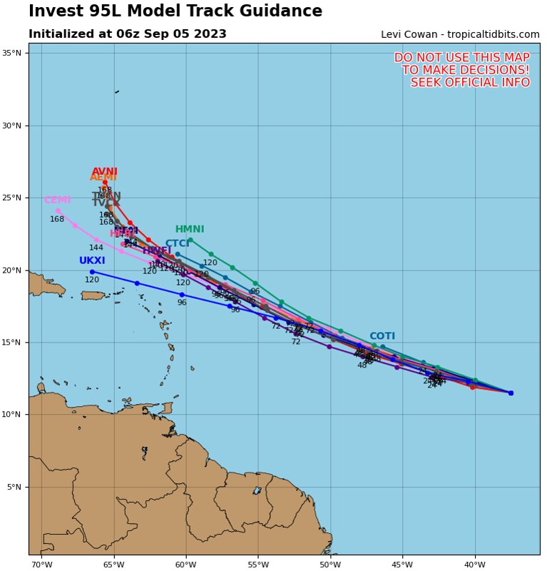

Today, the guidance shows that by the time it gets to 60-degrees West, it will be at least at 22-degrees North and moving northwest. Two days ago, at 60-degrees West it was at 20-degrees North. That is a 138 mile shift to the north.
Today’s guidance shows it turning more northerly by 68-degrees West while two days ago it showed that turn at 65-degrees West – about a 200 mile shift west.
So it has both shifted north in the shorter term and shifted west a bit farther out. Neither of those moves are south. And, on top of that, the moves leave Lee still 1,200 miles southeast of Cape Hatteras, North Carolina. And about 1,700 miles due south of the eastern tip of Maine when making said moves
Worth monitoring? Sure. Worth fretting over? Not at all.
Worth creating a big hub-bub over? I guess if you want clicks, shares and likes, sure.
And while I want to stress that this forecast is not set in stone, it also isn’t moving as much as people want you to believe – and fear.
[wpcode id=”41149″]
REGIONAL DAY TO DAY FORECAST
Today: Mostly sunny. A chance of showers and thunderstorms in the afternoon. Highs in the upper 90s. West winds 5 to 10 mph. Chance of rain 50 percent. Heat index values up to 108.
Tonight: Partly cloudy with a slight chance of showers and thunderstorms in the evening, then mostly clear after midnight. Lows in the lower 70s. Southwest winds 5 to 10 mph, becoming northwest after midnight. Chance of rain 20 percent.
Friday: Sunny. A slight chance of showers and thunderstorms in the afternoon. Highs in the mid 90s. North winds around 5 mph, increasing to around 10 mph in the afternoon. Chance of rain 20 percent.
Friday Night: Mostly clear. Lows in the upper 60s.
Saturday: Sunny with a slight chance of showers and thunderstorms. Highs in the mid 90s. Chance of rain 20 percent.
Saturday Night: Mostly clear. Lows in the upper 60s.
Sunday: Sunny. Highs in the mid 90s.
Sunday Night: Mostly clear. Lows in the upper 60s.
Monday: Sunny. Highs in the mid 90s.
Monday Night: Mostly clear. Lows around 70.
Tuesday: Sunny. A slight chance of showers and thunderstorms in the afternoon. Highs in the mid 90s. Chance of rain 20 percent.


