I know many of your eyes are out into the Atlantic on Tropical Storm Lee (still a tropical storm as of this writing, at 4am Wednesday). And while it is likely to grow into a formidable storm, it isn’t as likely to bother us.
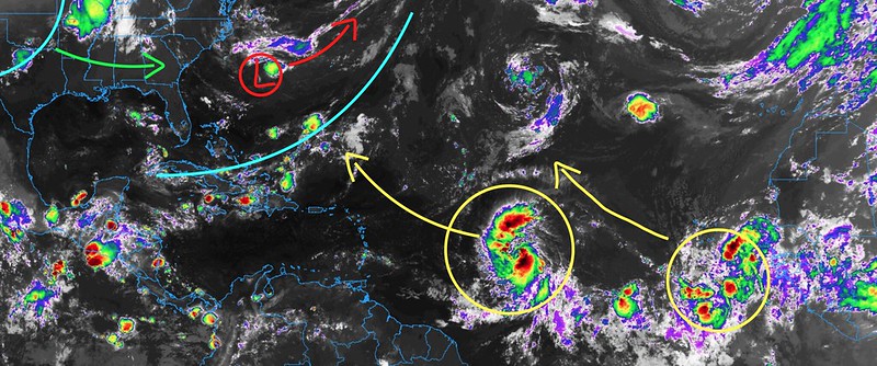
The current look into the Atlantic shows one trough currently elongated from off the coast of Maine all the way south to Cuba. With a second – weaker – trough in behind that in Texas.
Lee and the next wave are currently out into the middle of the atlantic (yellow circles) and set to turn northward along their journeys.
But man, the model guidance sure is aggressive with how strong Lee will be. Here is a look at the HWRF model looking out toward late Sunday night. Lee is shown as a buzz saw.

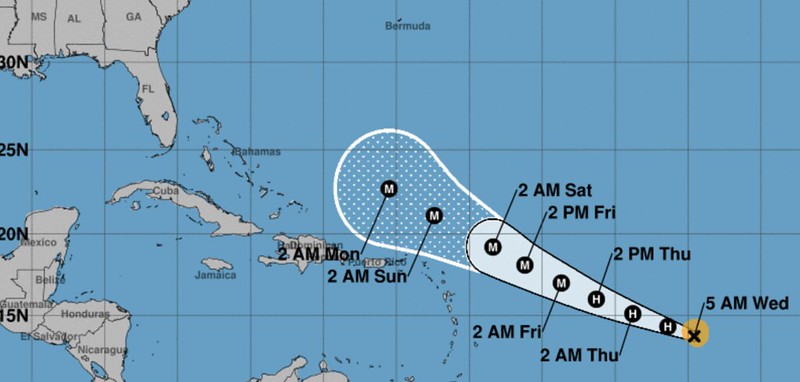
As a meteorologist, so far the intensity guidance and the forecast cone for Lee are awesome. The forecast from the NHC is to keep Lee away from land, thankfully. And the model guidance shows this thing growing quickly into a Major Hurricane.

So we get to watch, and learn, from a distance.
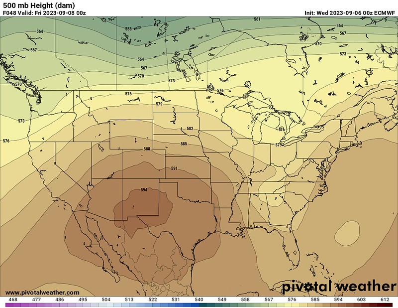
Back locally, the ridge of high pressure that has been anchored nearly all summer to our best will be there through Friday. The little trough I mentioned above isn’t going to bother the big ridge, it is simply riding around it.
That said, by the time we get into next week, I think the ridge does start to break down a bit and ease back to the west. This opens the door for another trough to swing through that should help give a bump to the shot or rain.

Between now and then, though, it’ll be dry. Models show only meager amounts of rain between now and next Monday afternoon. In fact, the model guidance below shows nearly all of Jones and Jasper counties bone dry.

So hang in there, we have another dry stretch headed our way. But that should start to turn around a bit as we move through next week.
[wpcode id=”41149″]
REGIONAL DAY TO DAY FORECAST
Today: Sunny. A chance of showers and thunderstorms in the afternoon. Highs in the mid 90s. Northeast winds around 5 mph, becoming southeast in the afternoon. Chance of rain 30 percent.
Tonight: Mostly clear. Lows in the lower 70s. South winds 5 to 10 mph, becoming southwest after midnight.
Thursday: Sunny with storms possible. Highs in the upper 90s. West winds 5 to 10 mph. Chance of rain 40 percent. Heat index values up to 107.
Thursday Night: Partly cloudy in the evening, then becoming mostly clear. Lows in the lower 70s. Southwest winds 5 to 10 mph, becoming west after midnight.
Friday: Sunny with a few storms possible. Highs in the upper 90s. Chance of rain 20 percent.
Friday Night: Partly cloudy in the evening, then becoming mostly clear. Lows around 70.
Saturday: Sunny. Highs in the mid 90s.
Saturday Night: Mostly clear. Lows in the upper 60s.
Sunday: Sunny. Highs in the mid 90s.
Sunday Night: Clear. Lows in the upper 60s.
Monday: Sunny. Highs in the mid 90s.
Monday Night: Mostly clear. Lows in the upper 60s.
Tuesday: Sunny with a few storms possible. Highs in the mid 90s. Chance of rain 20 percent.


