Multiple extreme flooding events have impacted parts of the Midwest this past week, some being considered ‘thousand-year floods’ meaning there is a 1 in 1000 chance of this type of flood occuring in any year. Meanwhile parts of the drought-ridden Southwest have been experiencing a different type of flooding: flash flooding, a rapid onset of inundation due to the dry surface that can’t easily absorb water. The exact locations of these events can be difficult to predict; however, there are some atmospheric ingredients that these two types of flooding have in common:

Weak winds at the 500mb level allows for storms and heavy rainfall to remain over the same area for extended periods of time. Today we have more of the same – subtropical ridging over the southern two-thirds of the U.S. bringing weak 500mb winds under 20kts. Embedded troughs slowly circumnavigating the areas of high pressure (one in Arizona and another in Eastern Iowa) can provide the atmospheric lift needed to produce heavy rainfall and have warranted the risk of flooding today.

There are three main areas being monitored for excessive rainfall today: parts of the Southwest where monsoonal moisture and dry soils will pose a flash flooding risk, the Southeast where ample low-level moisture and high PWATs in combination with diurnal convection will allow for heavy rainfall rates, and parts of Illinois, Indiana, and Missouri as the trough moves southeastward.
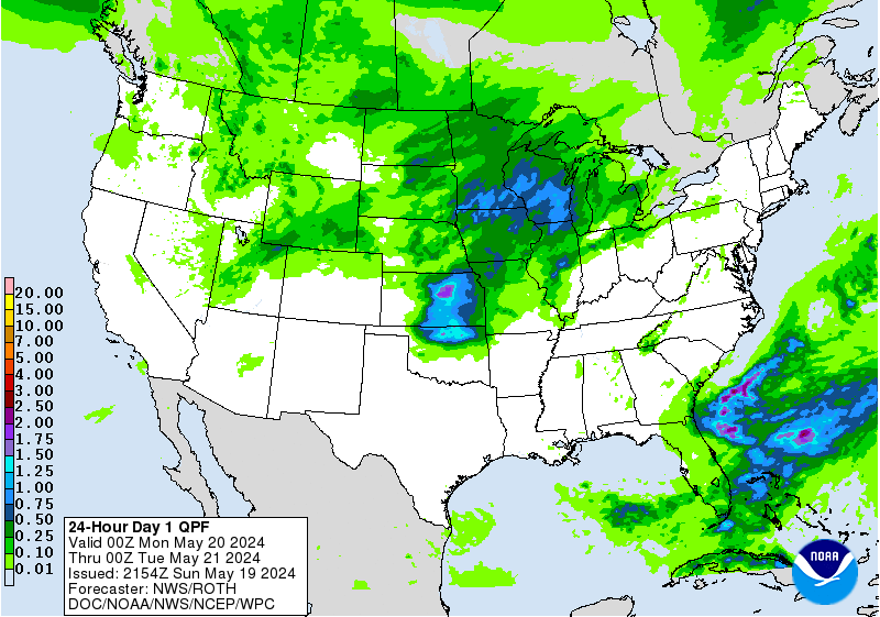
Widespread rainfall amounts exceeding 1″ are expected from southern Missouri through northern Indiana with locally higher amounts exceeding 3″ in southeastern Missouri and central/southwest portions of Illinois. Remember, running water across a roadway can be deceiving and only 6 inches of fast-moving water can cause cars to stall out, so remember to turn around, don’t drown!
Southwest & Great Plains Drought
Stagnant 500mb winds are forecasted to persist across most of the U.S. for at least the next 7 days keeping many places dry and hot while others receive an abundance of rain.

One of those areas that will receiving rain is parts of the Southwest thanks to monsoonal moisture making its way into the region. While it may not be enough rain to quench the drought entirely, any rain that does fall is very welcome.
Besides the flooding, the weather across the U.S. has remained relatively tranquil and hot (especially the Great Plains) thanks to the subtropical ridge pushing well into the CONUS; additionally, the Atlantic tropics have remained quiet the past month, but August is notorious for an uptick in activity, so expect to hear more on tropics later this month.


