Some spots are waking up this morning to thunder and rain, while others are still nice and dry. As of this writing, at 5a, the big shield of rainfall is over into western Alabama this morning, with another few showers and storms lined up south of Jackson along I-55.
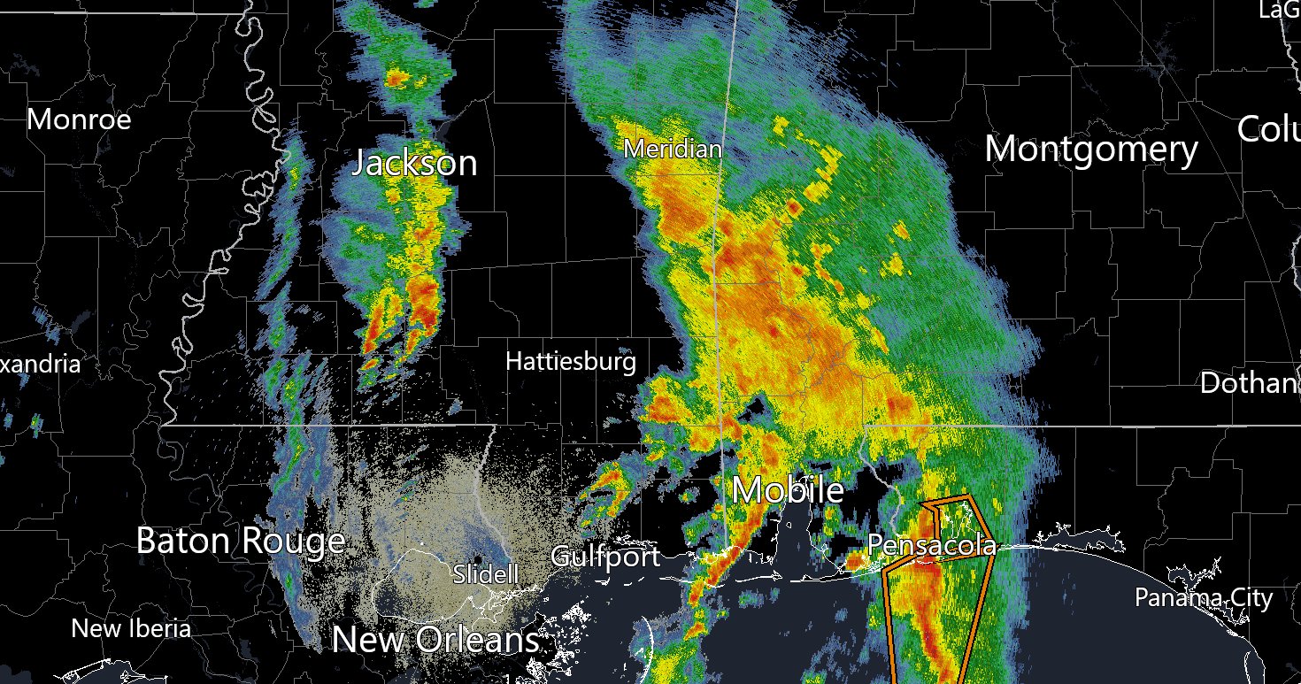
The storms along I-55 should stretch out a bit and press across the area during the next few hours. Severe weather isn’t anticipated, but you may get some brief heavy rain, lightning, and some gusty wind.
Then this afternoon another round of storms will develop and swing through.

Severe weather isn’t anticipated here, either. And again, brief heavy rain, lightning, and gusty wind will be the main concern. And once it slides through, we should get a break later this evening after dinner and toward midnight.
But overnight there could be another round of rain that tries to push through.

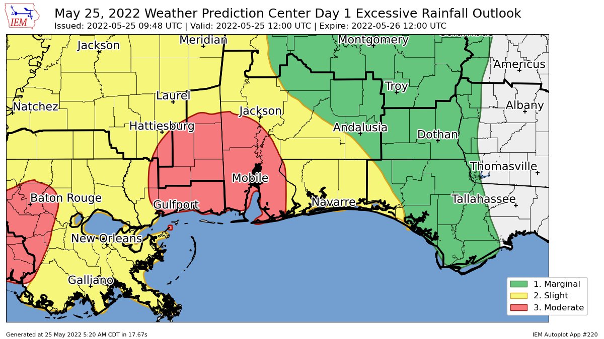
And at this point we may start to worry more about localized flooding. Because some spots may get rain with each round. And it’ll be a lot of rain in some places. Looking at the rainfall totals from the HRRR model, there are many spots that will be in the 3″ to 5″ range. With some places showing more than 8″ of rainfall.

Like I always say, when you look at these rainfall estimation maps, always take the specific placement with a grain of salt, and instead use it as a good “fence” to determine how much rain is possible for you. For example, folks in Perry County, MS are looking at a chance for between 3″ and 8″ of rain between now and the time you wake up tomorrow morning. Simpson County, MS is looking like 1″ to 4″ of rain. But you folks could be sitting underneath an up to 9″ of rain bullseye, too.
And that is on top of the 1″ to 2″ of rain some spots have picked up the last two days.
Because of all of that, the WPC has issued a Moderate Risk for flash flooding, particularly closer to the coast. That is a “3” on the 1-to-4 scale where a “4” is the highest risk for the most significant flash flooding to occur. Elsewhere, most other places in the area are under a “2” on the same scale.
So make sure as you head to bed tonight, if you live in an area that usually sees flooding, that you have a way to get alerted overnight should a flash flooding warning or a flash flood emergency be issued.
Timeline
The good news is that the round of rain overnight isn’t as likely as the storms moving through this afternoon. I’d still like to see how things progress today before jump “all in” on the overnight rain chance.
But here is a look at the timeline for rain across the region.

Because of the scattered nature of storms, please know that while it may be “red” at a certain time, you may still end up dry for an hour or two while you wait for the storms to make it to you. Always make sure you’ve got access to a radar to double check the conditions.
And know that you can always grab a look at the radar here and here!
Day to Day Forecast
Today
Mostly cloudy with storms likely. Locally heavy rainfall possible. Highs in the mid 80s. Chance of rain 90-percent.
Tonight
Cloudy with more storms overnight. flash flooding possible. Lows in the mid 60s. Chance of rain 70-percent.
Thursday
Mostly cloudy with storms ending in the morning with a few more isolated storms in the afternoon. Highs in the lower 80s. Chance of rain 40-percent.
Thursday Night
Mostly clear. Lows around 60.
Friday
Sunny. Highs in the mid 80s.
Friday Night
Mostly clear. Lows around 60.
Saturday
Sunny. Highs in the mid 80s.
Saturday Night
Clear. Lows in the lower 60s.
Sunday
Sunny. Highs in the upper 80s.
Sunday Night
Mostly clear. Lows in the mid 60s.
Memorial Day
Sunny with a 10-percent chance for a passing storm possible. Highs around 90.
Monday Night
Mostly clear. Lows in the upper 60s.
Tuesday
Sunny with a 10-percent chance for a passing storm. Highs in the lower 90s.


