NHC notes two areas of interest in tropical Atlantic
Author: Nick Lilja
|| Published: 7/21/2020 at 9:48am
10:00AM UPDATE:
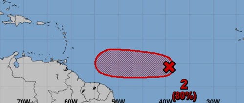
Satellite imagery and recent satellite wind data indicate that the low pressure system located about midway between the west coast of Africa and the Lesser Antilles continues to get better organized. If current trends continue, advisories could be initiated on this system as a tropical depression later today. Regardless of development during the next couple of days, less favorable conditions should limit additional development by the weekend.
Courtesy: nhc.noaa.gov
* Formation chance through 48 hours…high…80 percent.
* Formation chance through 5 days…high…80 percent.
ORIGINAL:
The National Hurricane Center continues to monitor two areas of interest in the Tropical Atlantic. One area is nearing the Gulf of Mexico with a 40-percent chance for development between now and this weekend. The second area is east of the Greater and Lesser Antilles with a 60-percent chance of development by this weekend.
From the NHC
Tropical Weather Outlook
NWS National Hurricane Center Miami FL
800 AM EDT Tue Jul 21 2020
For the North Atlantic…Caribbean Sea and the Gulf of Mexico:
1. A tropical wave is producing a large area of disorganized showers and thunderstorms over western Cuba, the northwestern Bahamas, southern Florida, and the adjacent Atlantic and Caribbean waters. Gradual development of this system is possible while it moves west-northwestward during the next few days. This system is expected to move over the southeastern Gulf of Mexico later today, the central Gulf on Wednesday, and the northwestern Gulf on Thursday and Friday. An Air Force Reserve Hurricane Hunter aircraft is scheduled to investigate the system this afternoon, if necessary.
* Formation chance through 48 hours…low…30 percent.
* Formation chance through 5 days…medium…40 percent.
Courtesy: nhc.noaa.gov
2. Showers and thunderstorms have become better organized in association with a low pressure system located about midway between the west coast of Africa and the Lesser Antilles. Environmental conditions are expected to be somewhat conducive for development, and a tropical depression could form during the next day or two while the low moves westward at around 10 mph over the tropical Atlantic. By the weekend, however, less favorable conditions should limit additional development.
* Formation chance through 48 hours…medium…60 percent.
* Formation chance through 5 days…medium…60 percent.
It is worth noting that neither of these system pose an imminent threat for Rapid Intensification at this time. Model data shows both areas of interest trying to get better organized during the next 48 hours, but nothing drastic or “out of the ordinary” is being shows in the computer model data. That means development – if at all – will be slow.
The good news is that gives meteorologists plenty of time to track changes and figure out where both of these are headed.
Where are these headed?
The area of interest in the Gulf is likely headed toward Texas or Louisiana. Right now the data suggests that it will mosey across the central Gulf as we move through this week and arrive in Texas just in time for the weekend. Because this system is still disorganized without a known center of circulation, the models are having a difficult time pinning down exactly there this will go and exactly how organized and strong it will be. But, the available data shows it will most likely be a tropical depression or weak tropical storm as it gets closer to Texas.
Could that change? Absolutely. In fact, I would almost guarantee that it will change. Sadly, before storms actually form a center of circulation, the models aren’t always the best at figuring out what will happen.
The second ara of interest out in the open Atlantic has a pretty good chance of sneaking into the Caribbean as a tropical depression or tropical storm. However, once it gets into the Caribbean it looks like the environment for sustaining a tropical system will be much less favorable. So, once it makes it there, regardless of what it looks like, it is likely to be eaten by wind shear.
The bottom line
Keep tabs on the forecast, and double-check your Hurricane Preparedness Kit. If you live in Mississippi, Alabama, or Florida, these storms are unlikely to bother you… But it is always good to be prepared. Just watch out for some extra rain layer this week with the potential for some localized flooding.
If you live in Louisiana or Texas, double-check your Hurricane Preparedness Kit and keep tabs on the forecast, too. But also recognize that the first area of interest in the Gulf may be headed your direction. As of now it looks like heavy rain, localized flooding, and gusty wind may be possible this weekend.
Author of the article:
Nick Lilja
Nick is former television meteorologist with stints in Amarillo and Hattiesburg. During his time in Hattiesburg, he was also an adjunct professor at the University of Southern Mississippi. He is a graduate of both Oregon State and Syracuse University that now calls Houston home. Now that he is retired from TV, he runs this site and its app in his spare time.