Mother Nature doesn’t often get compared to boxing, but this weekend the southern plains will be facing a one-two punch of systems giving the area decent chances for rain.
Scenario
As one area of low pressure slides in the region from the west, it will offer enough of an upper-level ‘umph’ to squeeze out some raindrops while another system slides in from the north to offer a reinforcing shot of both ‘umph’ and cold air.
The threat for severe weather is possible ahead of these two systems, but the main threat will be for beneficial rainfall.
Quick Breakdown
Most of the southern plains will still be dealing with pre-frontal ridging on Friday out ahead of the first system set to move into the area late Friday and into Saturday. That means temperatures in the 60s and 70s for most of the region. If the first system pushes east faster than anticipated there is a chance places like Lubbock and Vernon could see a quick thunderstorm move through after 4pm.
While the SPC is forecasting the more “severe” weather in east Texas, the southern plains will have a chance for a few moderately-severe storms, too.
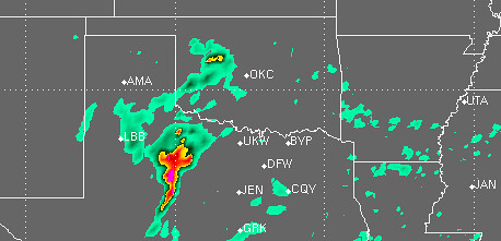
Showers and thunderstorms should begin to initiate Saturday morning given weak instability and greater forcing. While there will still be a slight capping inversion in place, surface dewpoints in the 40F to 50F range, a few thunderstorms can’t be ruled out. Places like Abilene, Texas back through Lawton, Oklahoma could see a weak thunderstorm in the morning. Greater instability will arrive in the afternoon
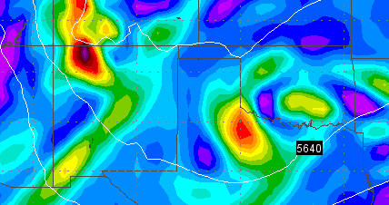
Modest CAPE values of 200 J/kg to 800 j/kg will be realized during Saturday morning while CAPE values near 1400 J/kg will take hold into the afternoon. This modest instability will spread across a broad area of north Texas, central and western Oklahoma, as well as south central Kansas. This will help spark strong-to-severe storms for places like Abilene, Texas north through Denton, Texas and into Oklahoma City, Oklahoma as the afternoon unfolds
Despite CAPE in the 1k range, Lifted Index values will fluctuate between -1C and -4C throughout that same area – which should help marginalize the severe weaher threat. Keep in mind, often a L.I. value greater than (closer to zero) -4C is associated with marginally severe weather.
The main threats in area that have a chance at stronger storms will be high winds and moderate-sized hail. The tornado threat, as it appears right now, is nearly zero.

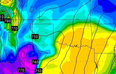
While all of the thunderstorms are rumbling through parts of central Oklahoma and east Texas, a cold front is going to push south across the western edge of the southern plains. Behind the front there will be enough post-frontal moisture to squeeze out a few more showers and perhaps even a rumble of thunder. While places like Hays, Kansas, to Guymon, Oklahoma, and Amarillo, Texas might miss out on a bulk of the thunderstorm chances, the cold front barreling south will offer another shot at rain.
Late Saturday, behind said cold front winds look to increase between 20mph and 40mph with gusts nearing 60mph possible. So for places that didn’t see any rain, it could be another dusty night.
By Sunday, the systems move out and the area will clear out and calm down.
Summary
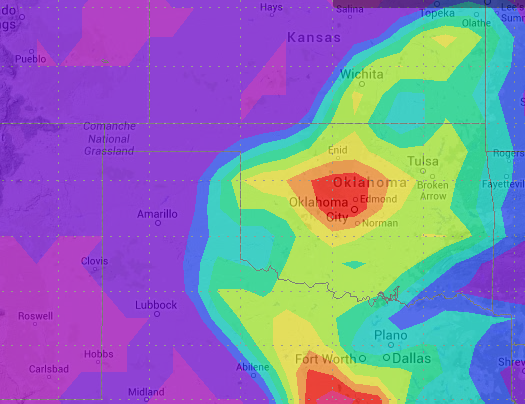
As of this writing here are the rain chances and estimated averaged rain totals for a few select cities given the current computer weather model trends…
Abilene – 50% || .50″ – .75″
Amarillo – 40% || .10″ – .25″
Dallas – 60% || 1.00″ – 1.25″
Lubbock – 50% || .25″ – .50″Guymon – 30% || .10″ – .25″
Lawton – 60% || 1.25″ – 1.50″
Oklahoma City – 70% || 2.00″ – 2.25″Dodge City – 30% || .10″ – .25″
Hays – 30% || .10″ – .25″
Wichita – 50% || .75″ – 1.25″
While this won’t “bust” the drought, it will do a number to shifting the dryline farther west as spring progresses.


