Severe Weather looks likely for some folks in the Pine Belt as a line of showers and storms roll through the area late Monday and into Tuesday morning.
Threats
Heavy rain (but not a lot, sadly) with up to 1″ possible for most, damaging wind up to 75mph, small hail, and a few isolated tornadoes will be possible.
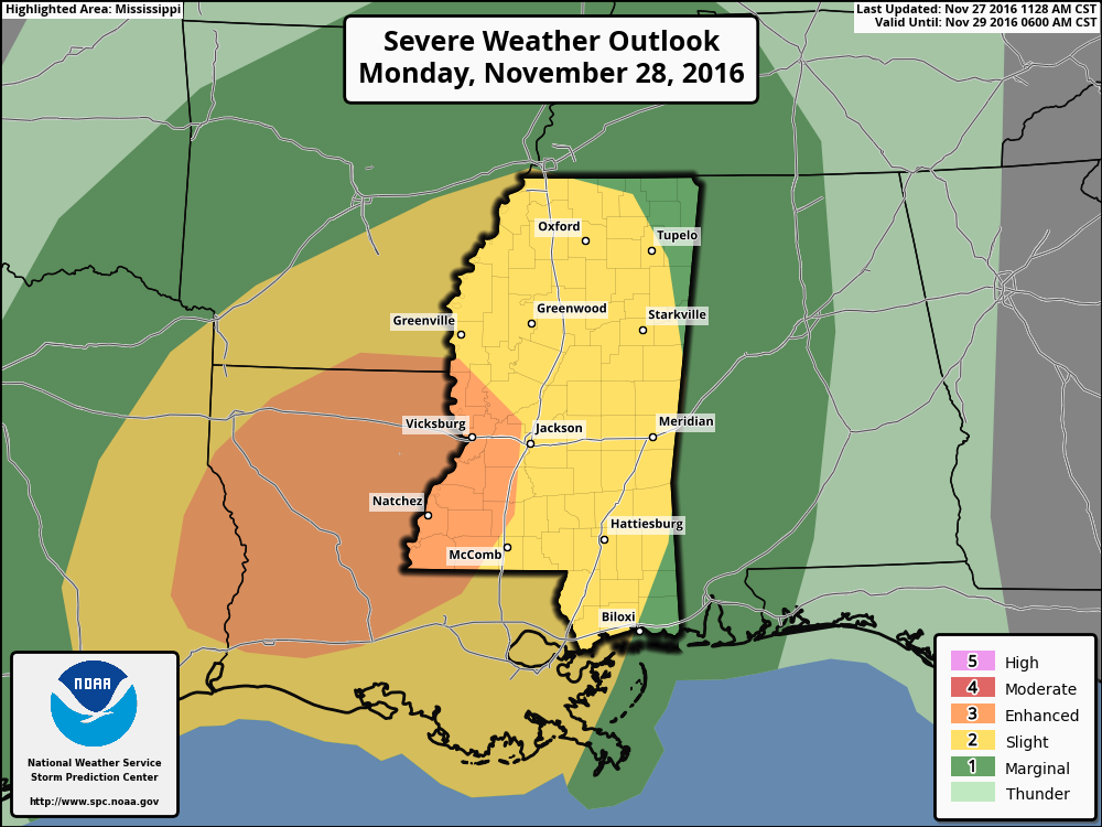
The latest forecast from the SPC on Sunday night shows the greatest risk for severe weather across parts of Louisiana and western Mississippi. While the percentage risk for tornadoes isn’t listed by the SPC yet, I would guess an area of 5% tornado risk will be highlighted in the “Enhanced Risk” area (orange) on the map.
A 2% tornado risk area will likely be outlines in the area highlighted in the “Slight Risk” area (yellow).
And be you say, “Just a 5% risk? No biggie! I’ll never see a tornado!” please keep in mind that means you are five-times more likely to see a tornado Monday night and into Tuesday than you are on any normal day.
Same rule applies to the 2% area.
From CIPS
The risk for long-track, devastating tornadoes looks relatively low right now. Looking at the CIPS Analogs from Saint Louis University (it looks back at similar atmospheric setups, and what severe weather happened) it shows that in the Top 15 most similar situations there was only a long-track tornado four times and a significant tornado four times.
So I did some digging and I couldn’t find that many. In fact I could only find one. And while that isn’t zero, it is good to know that the number is lower.
As an example, 11/28/94 is the third-highest analog (out of the Top 15), meaning on the list, it is looks pretty similar to the forecast atmosphere Monday night but it isn’t the best. There was an F3 tornado that day in Simpson, Smith and Jasper counties
Here is the report from the NWS:
This tornado touched down 1 mile northwest of Magee in Simpson County moved northeast and moved into Smith County, 4 miles southwest of Cohay, at 2225CST. The tornado moved across Smith County and moved into Jasper County, 4 miles west of Louin, at around 2300CST. The tornado lifted at 2315CST 3 miles south of Baxter. The most intense segment of this tornado (F3) was when it moved across the north portions of Magee. Forty to fifty houses or mobile homes had major damage. Two people were killed in Magee when a large tree fell across their mobile home. Most of the damage in Smith County was to trees and power lines. In Jasper County, several chicken houses were destroyed around Montrose and most other damage as to trees. The tornado was weaker in Smith and Jasper counties and ranged from F0-F1. F38M M02M
Other than that, most of the tornadoes reported were EF-1 or weaker.
Timing
For the Pine Belt, I think we start to see showers and storms develop around 6pm across our western counties – places like Simpson, Lawrence, and Walthall counties. Severe weather may hold off until 8pm, though.

By 8pm, most places west of I-59 will start to see an up-tick in showers and storms. And an increase in the threat that a storm turns severe.
By 10pm, the entire swath of southern Mississippi will be looking at the chance for rain and showers and storms.
Beyond that, we just can’t know. A lot of folks message me and ask things like, “I have a birthday party at 7:30pm in Jones County 2 miles south of HWY 84 and I will be setting out chairs at 430pm will it be raining then?”
I don’t know. I can’t know. And anyone who says they can tell you, is lying. Sorry.
Uncertainty is tough
And really, at this distance in time, we can’t even tell you who will see the “worst” weather, either. I can tell you that the entire area is looking at the threat for severe weather, but until tomorrow at – about noon – we won’t have enough data to know which little areas in Pine Belt have the better shot to see the worst storm.
And even then, all we can tell you is where the parameters are the most conducive – or set up in a way that makes it easier – to produce severe weather. Doesn’t mean it will. And it doesn’t mean someone else won’t see bad weather, too.
Uh oh, Tangent time!
If I could tangent for a moment, in 90s and early 2000s a lot of local TV stations got a hold of computer weather model data that could spit out forecasts and futurecasts and all of this stuff. They took it and ran with it. And it wasn’t as much the meteorologists as it was the consultants and CEO-types. That is when things like “Super Doppler 10,000 hyper local 3D radar plus” came to be and “Pinpoint Weather Team with street-level accuracy on your 7 day forecast!” started being promoted.
And it was great! Right? Wait… No! No it wasn’t at all!
They quickly found out that these models were good at “big picture” stuff, but in terms of forecast accuracy at street-level, or “at your front door!” as they put it, wasn’t great.
And it still isn’t.
But for 15 years everyone (including me in my youth days) heard all about it. So, even as the forecasts get better today, they still come up short of people’s expectations of “What is the weather going to do at my house next week at 2pm?” because that is what was sold to them for a long time.
</End Tangent>
What we can do now is try to re-educate people on uncertainty within a weather forecast. And a lot of great strides are happening because you folks at home are starting to ‘totes’ get it. And that is awesome! Because weather isn’t black and white, we can’t give a black and white forecast.
And the better we – the public and meteorologists – work together to get that, the better we will be at preparing for the rough stuff!


